PhiEaglesfan712
-
Posts
1,718 -
Joined
-
Last visited
Content Type
Profiles
Blogs
Forums
American Weather
Media Demo
Store
Gallery
Everything posted by PhiEaglesfan712
-
E PA/NJ/DE Winter 2025-26 Obs/Discussion
PhiEaglesfan712 replied to LVblizzard's topic in Philadelphia Region
Uh, we had a January thaw from about 1/6-1/15: 2026-01-06 45 31 38.0 3.7 27 0 0.00 0.0 0 2026-01-07 57 38 47.5 13.3 17 0 0.00 0.0 0 2026-01-08 55 34 44.5 10.5 20 0 0.00 0.0 0 2026-01-09 57 31 44.0 10.1 21 0 0.04 0.0 0 2026-01-10 50 43 46.5 12.7 18 0 0.96 0.0 0 2026-01-11 49 36 42.5 8.8 22 0 0.01 0.0 0 2026-01-12 45 30 37.5 3.9 27 0 0.00 0.0 0 2026-01-13 51 28 39.5 6.0 25 0 0.00 0.0 0 2026-01-14 57 44 50.5 17.1 14 0 0.00 0.0 0 2026-01-15 45 25 35.0 1.7 30 0 0.03 T 0 -
E PA/NJ/DE Winter 2025-26 Obs/Discussion
PhiEaglesfan712 replied to LVblizzard's topic in Philadelphia Region
17 years ago (February 3-4, 2009):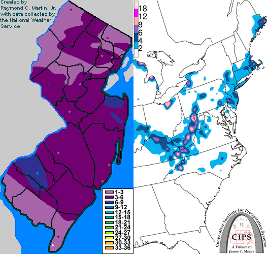
-
2025-2026 ENSO
PhiEaglesfan712 replied to 40/70 Benchmark's topic in Weather Forecasting and Discussion
What month is this future's contract for? March or April? -
2025-2026 ENSO
PhiEaglesfan712 replied to 40/70 Benchmark's topic in Weather Forecasting and Discussion
We had April torches in 2017 and 2019 (those were two of the warmest Aprils ever), as well as the first half of April 2023 (before we turned cold, which lasted until the end of June). Thing about February is that it's only 28 days. The cold beginning is going to eat a good chunk of the month. For the warmer days to eventually outweigh the colder days, we're going to need to string together some record-breaking, 70+ heat. I just don't see it happening. -
2025-2026 ENSO
PhiEaglesfan712 replied to 40/70 Benchmark's topic in Weather Forecasting and Discussion
BN, I'm getting March 2015 vibes. The first week being well below average, a continuation of the previous month, and set the tone for the month, but I feel like a pattern change is coming, with the string of below average months coming to an end soon. Something tells me March is going to be above average (like April 2015), and April is going to be a near record warm month (like May 2015). -
2025-2026 ENSO
PhiEaglesfan712 replied to 40/70 Benchmark's topic in Weather Forecasting and Discussion
Definitely not a March 2018 redux. That was a record snowy March here at PHL, and quite frankly, I can't see that outcome happening again. At some point, I've got to think this string of cold months has to end at some point. Even in 2018, we had the very warm February that interrupted an otherwise cold and snowy winter pattern. -
2025-2026 ENSO
PhiEaglesfan712 replied to 40/70 Benchmark's topic in Weather Forecasting and Discussion
2023 just took too long to develop. By the time things turned cold, it was already May and June, and the snow season was over. We got our coldest June since 1985, and (tied with 3 other years) for 31st coldest June overall at PHL. To put into perspective how impressive that cold was, December 2025 was only the 48th coldest December, while January 2025 was the 46th coldest and January 2026 was the 59th coldest January in PHL. -
2025-2026 ENSO
PhiEaglesfan712 replied to 40/70 Benchmark's topic in Weather Forecasting and Discussion
Yeah, the last time we had record warmth in the West, at least the East had some historical cold. As cold as this winter has been in the East, it doesn't hold a candle to 13-14 and 14-15. -
2025-2026 ENSO
PhiEaglesfan712 replied to 40/70 Benchmark's topic in Weather Forecasting and Discussion
The odd thing about 2012 and 1977 is that both ended up producing record warm springs in most of the eastern half to two-thirds of the US. -
E PA/NJ/DE Winter 2025-26 Obs/Discussion
PhiEaglesfan712 replied to LVblizzard's topic in Philadelphia Region
Tinicum Twp is where the Airport is, and PHL had a low of 10 this morning. -12 (or 22 degrees colder) seems impossible, and it would be lower than PHL's lowest ever temperature, which was set in February 1934. I'd be willing to bet the low is somewhere in between both. 10 seems too high, -12 seems too low. -
E PA/NJ/DE Winter 2025-26 Obs/Discussion
PhiEaglesfan712 replied to LVblizzard's topic in Philadelphia Region
That statement isn't even correct. January 2010 wasn't below average temperaturewise, and both November 2009 and March 2010 were really warm. 2009-10 had historical snow, but it was done in a very short window, and wasn't really historically cold. After snowmageddon, the winter was pretty much over, and we had 90 degree temps in early April (years like 95-96, 02-03, and 13-14 - all wall-to-wall cold and snowy winters - it was still snowing at that point in the season). -
E PA/NJ/DE Winter 2025-26 Obs/Discussion
PhiEaglesfan712 replied to LVblizzard's topic in Philadelphia Region
Both had more intensity/longevity, and went on later. Based on 1981-2010 normals, January 2014 was -4.6, February 2014 -3.6, and March 2014 -4.6 departure (November 2013 was -2.1). January 2015 was -2, February 2015 -10, and March 2015 -4.4 (November 2014 was -2.4). December is the only month preventing 13-14 and 14-15 from having a wall-to-wall 5 months (November-March) below average. -
E PA/NJ/DE Winter 2025-26 Obs/Discussion
PhiEaglesfan712 replied to LVblizzard's topic in Philadelphia Region
I was a junior in high school, taking the SATs that morning. It snowed pretty much the whole day, as far as I can remember. That was the last time a clipper (turned Nor'easter) really produced. 2026 joins 2005 and 2016 in the Conference Championship weekend snowstorms. Mark one down for 2036 or 2037 next? -
E PA/NJ/DE Winter 2025-26 Obs/Discussion
PhiEaglesfan712 replied to LVblizzard's topic in Philadelphia Region
The record for the snowiest winter in Levittown is still 1957-58, correct? -
2025-2026 ENSO
PhiEaglesfan712 replied to 40/70 Benchmark's topic in Weather Forecasting and Discussion
The 10-year snow drought is over: https://x.com/amarkowitzWX/status/2015592086276313584 -
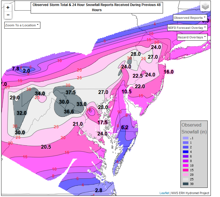
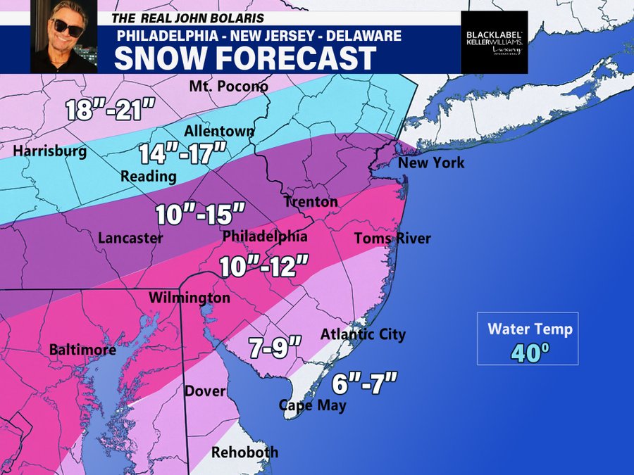
January 25-26 Winter Storm Potential
PhiEaglesfan712 replied to Ralph Wiggum's topic in Philadelphia Region
-
2025-2026 ENSO
PhiEaglesfan712 replied to 40/70 Benchmark's topic in Weather Forecasting and Discussion
Probably more muted. I highly doubt we see a record February warm, then a record snowy March, like we did in 2018. Both months will probably be much closer to normal, and I wouldn't be surprised if one actually had a +5 departure. -
January 25-26 Winter Storm Potential
PhiEaglesfan712 replied to Ralph Wiggum's topic in Philadelphia Region
The HECS was in March 1958. This followed another HECS on Valentine's Day that year. 1957-58 was that era's snowmageddon. In many places, it still holds the record for the snowiest season on record. That was a strong el nino year, like 2009-10, which produced the snowmageddon. The crazy thing about 2009-10 is how quickly that winter wrapped up after the snowmageddon event. It legit felt like summer during the first week of April that year. -
January 25-26 Winter Storm Potential
PhiEaglesfan712 replied to Ralph Wiggum's topic in Philadelphia Region
What does warmer years mean? Post-1997? Post-2015? -
January 25-26 Winter Storm Potential
PhiEaglesfan712 replied to Ralph Wiggum's topic in Philadelphia Region
I moved my Vermont trip to March 7-9. We can be sure there won't be a snowstorm that weekend, right? -
2025-2026 ENSO
PhiEaglesfan712 replied to 40/70 Benchmark's topic in Weather Forecasting and Discussion
I'm skeptical of a super nino developing in 2026-27. They normally don't develop that strong on the first try. 2015-16 is a very good example. Some models were predicting a possible strong el nino as early as 2012-13. I think if there's a super el nino, it will more likely happen in 2027-28. If the el nino happens in 2026-27, I think it will be capped at a high end moderate, possibly low end strong. (We also cannot count out the possibility of a double-year el nino, peaking during the summer, like 1986-88.) -
January 25-26 Winter Storm Potential
PhiEaglesfan712 replied to Ralph Wiggum's topic in Philadelphia Region
The last map I remember that looked like this was the one 10 years ago, just before the January 2016 storm. -
2025-2026 ENSO
PhiEaglesfan712 replied to 40/70 Benchmark's topic in Weather Forecasting and Discussion
2016 was 10 years ago, not 5. Although, it does feel like it just happened. -
E PA/NJ/DE Winter 2025-26 Obs/Discussion
PhiEaglesfan712 replied to LVblizzard's topic in Philadelphia Region
It was 21 years ago today (Sgt. Pepper taught the band to play)... we actually had that happen. Then, of course, the Eagles would go on to win the NFC Championship. -
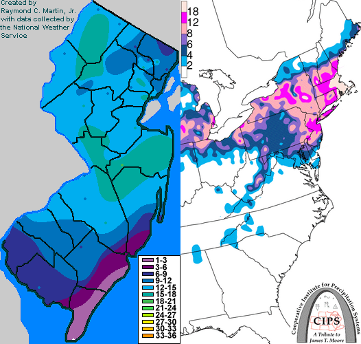
2005 2016