
Weathertree2
-
Posts
52 -
Joined
-
Last visited
Content Type
Profiles
Blogs
Forums
American Weather
Media Demo
Store
Gallery
Everything posted by Weathertree2
-
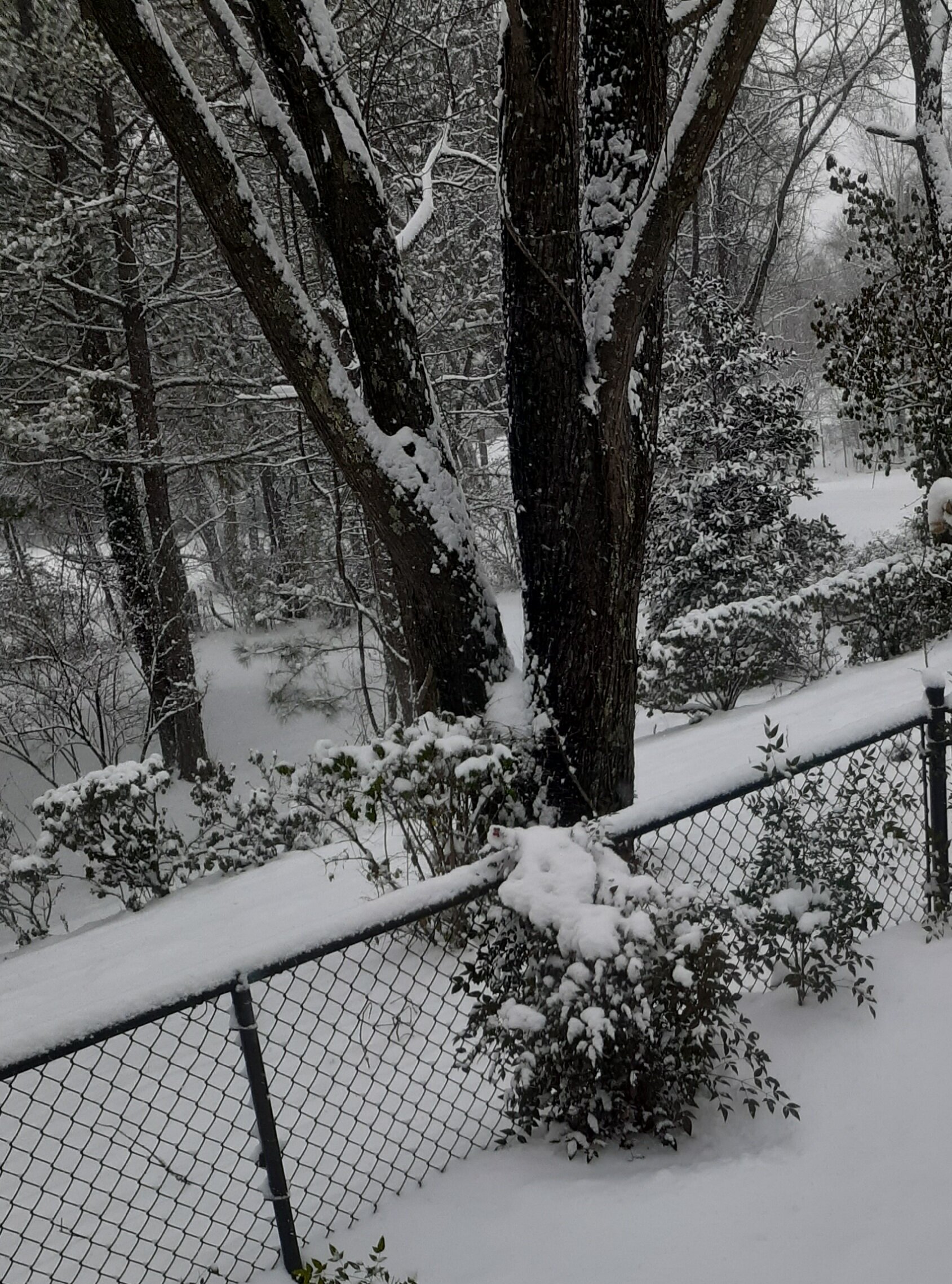
Had a few lightening flashes claps thunder this am.
-

Spring/Summer 2022 Medium/Long Range Forecast Discussion.
Weathertree2 replied to John1122's topic in Tennessee Valley
Already turning that way here in and around Middle TN -
March 11th-13th Winter Weather Event. Winter's last gasp?
Weathertree2 replied to Windspeed's topic in Tennessee Valley
000 FXUS64 KOHX 112030 AFDOHX Area Forecast Discussion National Weather Service Nashville TN 230 PM CST Fri Mar 11 2022 .DISCUSSION... Models have sped up this system for tonight a bit, and the cold front is a few hours ahead of previous forecast. But, snow timing remains roughly the same. Amounts have changed slightly, with more of the east possibly getting into the 2 to 3 inch range if the cold air continues moving in a little faster. Rest of the forecast remained mostly unchanged, with snow starting in the northwest around 6 pm and spreading across the mid state through the evening. Advisory area still looks to get 1 to 3 inches, and the Warning area 3 to 6 inches, with those higher amounts at higher elevations and on the Plateau. Upper trough continues to dig southward and strengthen as it approaches from the west, and the cold front has nosed its way into the northwest part of the mid state already this afternoon. Rain will start in isolated locations this afternoon ahead of the main band but precip chances increase from the northwest late this afternoon, and after a brief period of rain, a rain/snow mix and finally all snow will make a quick transition this evening. Some sleet will be possible mainly south and east of Nashville this evening, but it appears to be very brief as heavy snow bands will quickly cool any remaining warmer layers aloft. Isentropic lift remains strong ahead of the front, bringing plenty of moisture in the low to mid levels. Frontogenesis remains extremely strong also, and will support the very strong omega values that are clearly seen on soundings and cross sections. Cross sections also indicate some areas of weak instability, and combined with strong dynamic support in the mid to upper levels, heavy and potentially convective snow bands will be possible. These bands can easily be capable of bursts of 1 to 3 inches per hour, which is why the surface and near surface cooling a bit earlier has resulted in a little more accumulation in the northwest. The faster moving trough looks to exit sooner, with most of the mid state done with heavy snow before sunrise and lingering snow on the Plateau Saturday morning. Adding to the snow issue will be the strong northwest winds of 10 to 25 mph and gusts as high as 40 mph which could result in some downed power lines/trees when combined with the heavy snow. This still remains a challenging forecast as CAMs are the ones dialing back accumulations a bit, likely due to the increased speed of the system and more accountability for warm surface melting with initial snow compared to larger scale models. Upstream, there are reports of heavy snow, but mainly sticking to grass, cars, etc and leaving roads wet with the initial onset. Depending on how long temps can hold out on the surface, the warm pavement will rob some of the accumulation potential early on especially if snowfall rates are slow, but will still accumulate on cold surfaces. Should convective snow bands develop, or even within heavier snow bands, rapid cooling will result, and can easily start accumulating on area roads. Bridges and overpasses will be the first to start, but it is possible that slower snowfall rates in some areas will result in accumulations only on cold surfaces, and roads stay wet/slushy with slick spots in the western half of the mid state. On the other end, should heavy snow and convective bands last longer and be more frequent across the area, they can put down heavy snow amounts very quickly, and we may wake up with more snow than currently in the forecast. Definitely a challenging scenario with a quick moving, highly dynamic trough with convective snow potential. Models are still quick to bring clear skies on Saturday, but kept clouds in a bit longer. There is still a chance that a stratus deck lingers longer into the day Saturday preventing the sun from clearing the roads. Even though temperatures will be in the upper 20s to low 30s for highs Saturday, the March sun is still very powerful and can even get some melting done with a thin cloud layer. But, clear to partly cloudy skies in the afternoon would be ideal to help clear roads, especially with below freezing temps returning Saturday night and re-freezing any wet areas. Sunday will be much warmer, and likely get more of the snow melting job done with highs in the low to mid 50s. 60s return on Monday. Next chance at rain will be Monday night into Tuesday, but looks like this system will clip the south for the most part and doesnt look like a soaker at this time. Temps will continue to warm during the week and we will be back in the 70s by Wednesday. Another strong trough is possible next Friday into Saturday but this one will be warm enough to avoid any snow. && .AVIATION... 18Z TAF DISCUSSION. A strong cold front has passed through CKV and will shortly move through BNA/MQY shifting winds to the NW. Frontal passage will occur late this afternoon at CSV. Precipitation will move into the terminals this evening which could begin as rain showers but will quickly transition to snow. Snow will reduce vis to IFR and even LIFR during heavy bursts. Snow will move out of CKV around 08z and out of BNA/MQY around 09z. Snow will linger at CSV longer with some light snow showers possibly lingering after 12z. Models are quick to return VFR cigs after the snow pulls out, but with snow on the ground and steep low level lapse rates, MVFR cigs were left in the tafs for the remaining forecast to account for a likely stratocu deck. After frontal passage, winds will be out of the NW/NNW around 10-15 kts with gusts around 25 kts. -
Spring/Summer 2022 Medium/Long Range Forecast Discussion.
Weathertree2 replied to John1122's topic in Tennessee Valley
So, anyone have an early thoughts on the Spring/Summer? A continuation of a week of flood a week of dry? -
TN valley heavy rain/flooding week of whenever
Weathertree2 replied to janetjanet998's topic in Tennessee Valley
Me too but it is setting us up for a Spring that could be bad as far as flooding goes -
TN valley heavy rain/flooding week of whenever
Weathertree2 replied to janetjanet998's topic in Tennessee Valley
Does not look good any way you slice it honestly; essentially all of the rain we got last week ran off; any amount of rain will not be good for my area, north of Nashville -
Pix?
-
-
Especially north and northwest of Nashville
-
Yea, seems kind of odd looking at the watch/warning map to see the break in OHX territory
-
I personally agree with you but OHX is so so hard headed - according to their discussion, main thing to be concerned about is possibly ponding water in areas.... 000 FXUS64 KOHX 012040 AFDOHX Area Forecast Discussion National Weather Service Nashville TN 240 PM CST Tue Feb 1 2022 .DISCUSSION... Today turned out to be a very nice day. Temperatures warmed a bit more in some place than what was in the grids with some locations getting to 65/66 degrees across middle TN. This is going to change as we have been advertising. Rain moves in tonight close to midnight for the west and will spread east overnight. Rain becomes definite by tomorrow and heavy at times on Thursday. QPF amounts have came up a bit at this time from WPC guidance. Still expect 2.5" to 4" from 06Z Wednesday through 12Z Friday. Some locations could receive locally heavier amounts. Hopefully with it being so dry lately there will be no real flooding concerns outside of low lying areas and locations that are prone to flooding. Since the rain will be falling over a long period of time no type of flood watch will be need. Middle TN tends to have some flashy rivers/stream so advisories might be need by Thursday. As the system is pulling out Thursday night into Friday winterly weather is still expected. The GFS is the most aggressive with the cold air...and the other global models not as much. The northwest will have the best chance for mixed precipitation. The main concern is freezing rain. With the ground currently warm and a large warm nose /8 to 10C/ that is a lot of warm air to fall through. Freezing rain the greatest threat. It stays cold through the weekend with lows on Saturday in the teens to low 20s. Highs will climb to around 40. Not quite as cold Sunday morning...but still below freezing. A short wave moves across the south Sunday morning and this could bring a very small chance for rain/mixed precipitation for the plateau. Once we get through the weekend it will be dry for the beginning of the next work week with temperatures below climatology for this time of year...but warming through the week.
-
Yea, i am closer to the KY than i am BNA has me cautiously optimistic that we miss ice but going to be close
- 99 replies
-
- 1
-

-
- ice
- freezing rain
- (and 1 more)
-
I would imagine that there will be more changes with the 12z model suite
-
Gotcha
-
This implies a continuation of the current pattern?
-
The thing that is concerning to me is that the GFS has been creeping the line of ice slowly south with each run while other models have been showing it for a few days now
-
I must have missed that hardly seeing a thing for my area. You mean pattern wise?
-
That is some real-deal vodka cold in the Northern Plains, -45 wow, just one good system could pull that down right?
-
LR still looks cold; if we manage to put snow on the ground, we are going negative, those are some cold numbers!
-
GFS advertising a pattern that just keeps giving lol
-
Huge model swings from run to run for sure!
-
I was thinking same about the overrunning likely will be different next run but as you pointed out indicating the pattern general
-
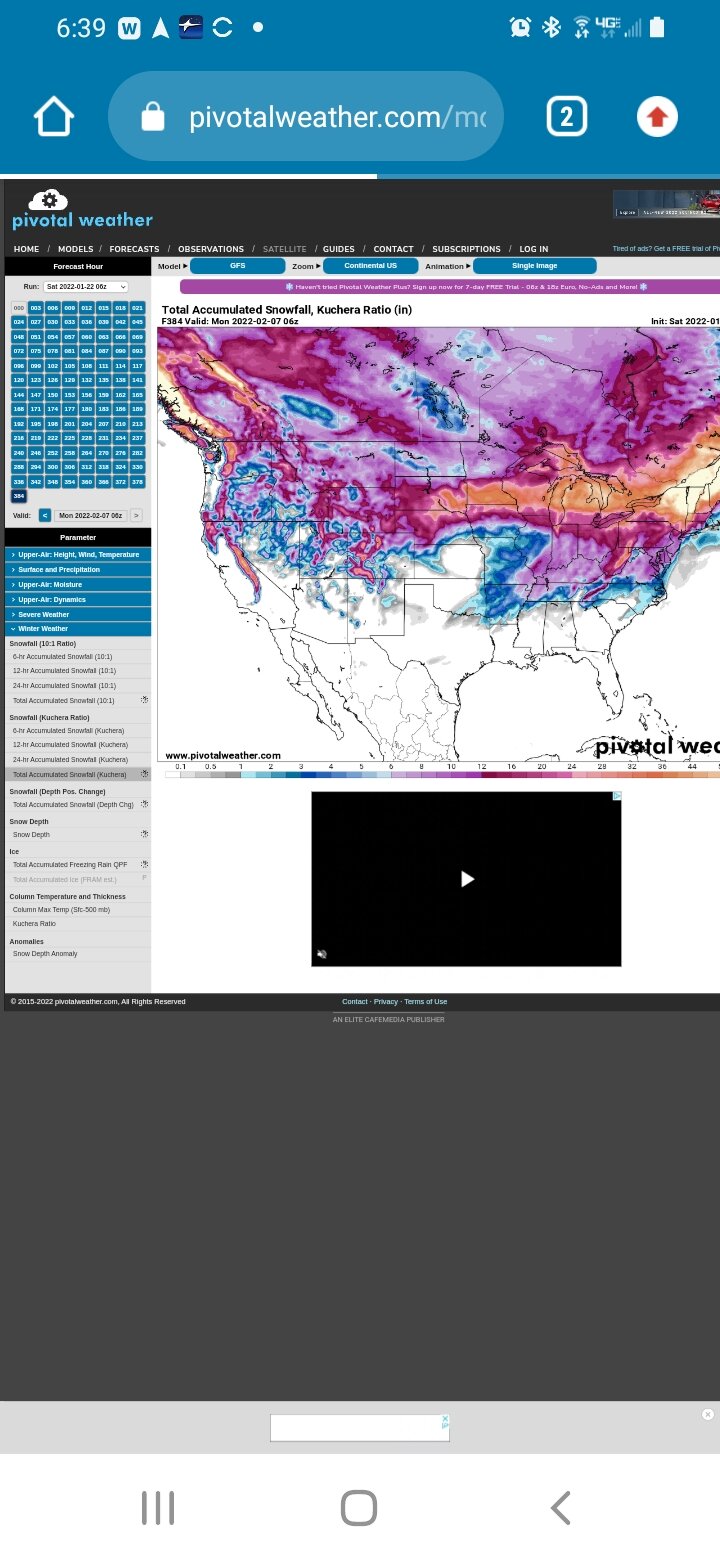
Great eye candy on the 6z run of gfs, my new screen saver
-
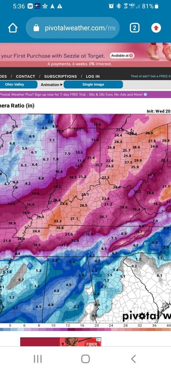
Looks like models are still struggling. 0z & 6z of gfs wildly different in long range. I think, for what's worth, the forum has chance for another couple ststem s before spring. Is this one of them? Perhaps.
-
Looks like a great run by 6z GFS for west/middle areas of forum