

TheClimateChanger
-
Posts
4,436 -
Joined
-
Last visited
Content Type
Profiles
Blogs
Forums
American Weather
Media Demo
Store
Gallery
Everything posted by TheClimateChanger
-
This is why I always use to say I’m a climate skeptic. Skeptical that it wasn’t much worse than the mainstream view, not that it wasn’t happening. They say it’s warmed 1C since preindustrial, but in fact it’s warmed nearly 1C just since the 1981-2010 average. This should be a smoking gun that they’ve been downplaying this, but I doubt that’s how many will report it.
-
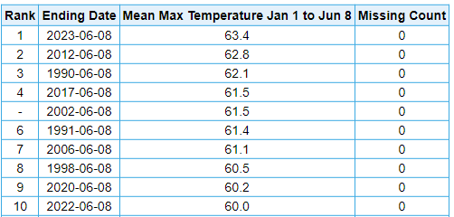
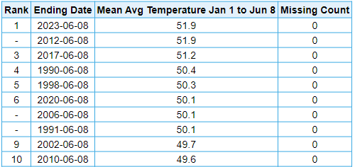
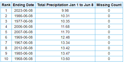
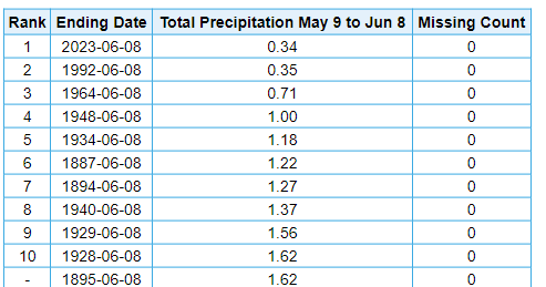
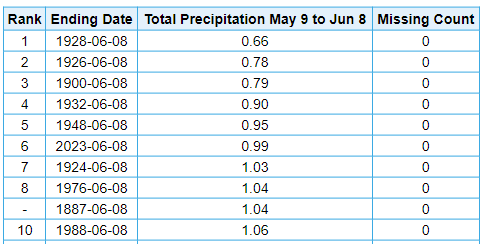
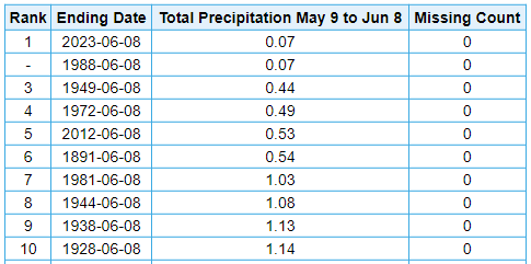
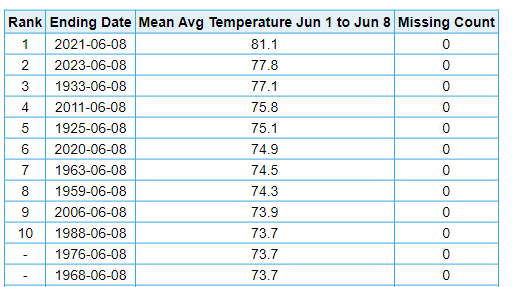
Driest and warmest year to date at IAD. For the record, DCA with a much longer POR, is 4th driest & 2nd warmest on record YTD.
-
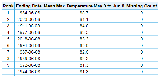
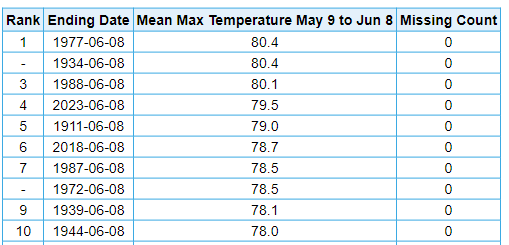
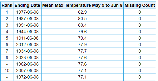
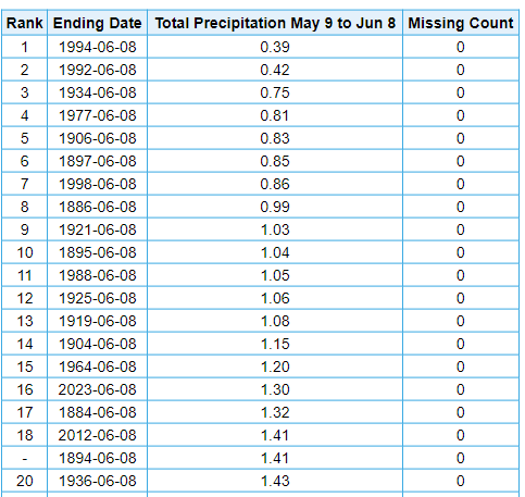
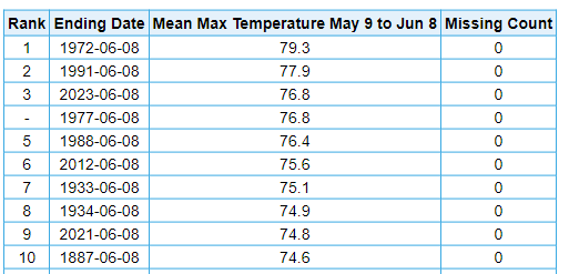
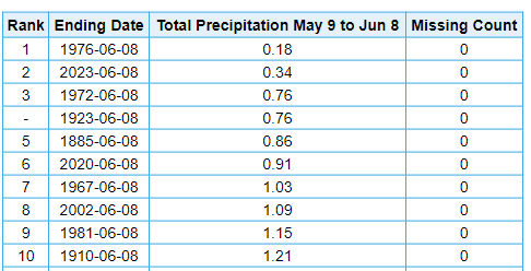
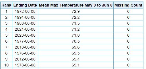
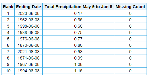
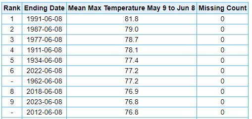
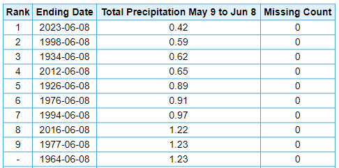
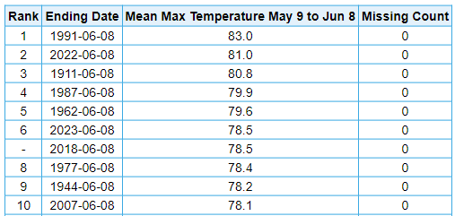
Looking back at the last 31 days, can certainly see the flash drought. Temperature rankings are based on mean maximum temperatures, which mitigates the urban heat island effects. I didn't realize it had been so warm, since a lot of the heat has been disguised in the means by somewhat cooler minima due to the dryness. Just by way of example, Moline is 2nd warmest by mean maximum temperature in the last 30 days, but would only be 13th if measured by mean. Chicago is 8th by mean maximum, but only 15th if measured by mean. For more extreme examples, Lansing is 7th warmest by mean maximum, but only 19th if measured by mean. Detroit is 9th warmest by mean maximum, but only 33th if measured by mean. Toledo is 6th warmest by mean maximum, but only 32nd if measured by mean. Moline, IL: Driest on record, 2nd warmest on record Minneapolis, MN: 6th driest on record, 4th warmest on record Chicago, IL (16th driest on record, 8th warmest on record) Green Bay, WI (Driest on record, 3rd warmest on record) Duluth, MN (2nd Driest on record, 5th warmest on record) Lansing, MI (Driest on record, 7th warmest on record) Detroit, MI (2nd driest on record, 9th warmest on record) Toledo, OH (Driest on record, 6th warmest on record)
-
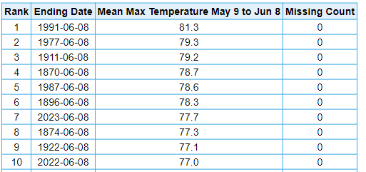
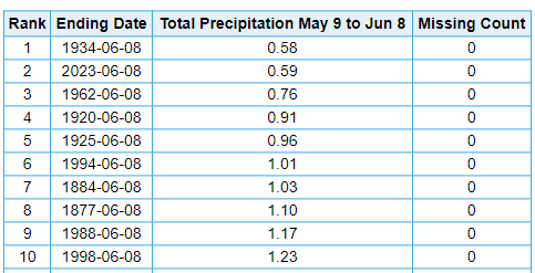
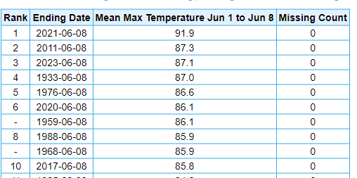
Looks like MSP is off to an absolutely scorching start to summer. Second warmest on record for first eight days of June, and would have been first if it occurred during or before 2020. Third warmest when measured by mean maximum to minimize impacts of growing UHI. Wouldn't have expected this with the northerly flow and wildfire smoke limiting insolation.
-
Central PA Spring 2023
TheClimateChanger replied to Itstrainingtime's topic in Upstate New York/Pennsylvania
DuBois received 0.11" of rain this morning. This is the first rainfall since May 20, and only the second since May 9 when a trace was recorded. The last measurable rainfall prior to May 20 was on May 7.
-
Pittsburgh/Western PA Summer 2023
TheClimateChanger replied to Ahoff's topic in Upstate New York/Pennsylvania
I think I can smell the fires now, unless it’s a local fire. -
Pittsburgh/Western PA Summer 2023
TheClimateChanger replied to Ahoff's topic in Upstate New York/Pennsylvania
Not sure if it runs a bit cool, but the AWOS at Zelienople Municipal Airport is down to a chilly 36 this morning: https://w1.weather.gov/data/obhistory/KPJC.html -
Pittsburgh/Western PA Summer 2023
TheClimateChanger replied to Ahoff's topic in Upstate New York/Pennsylvania
Pretty close to the record hourly minimum dewpoint at KPIT right now. -
Impressive to see a 6 degree temperature drop right around local solar noon just two weeks before the summer solstice. Like a miniature nuclear or impact winter.
-
Well, don't quote me on it. Was just soliciting Tip's thoughts. I did some research last month, because I was curious and I think I read where Australia's Black Summer produced up to 0.17C cooling in the southern hemisphere. That's also how I happened upon that curious event in September 1950. Not saying there's a link, but 1950 was the coldest year in the U.S. since 1929, and 1951 was even colder. There's only been a handful of years since that were colder than either of those years - which obviously mainly due to climate change. There was record breaking cold and snow in November 1950, and 1950-51 remains the snowiest winter on record in Pittsburgh. Ant Masiello seems to be the only met who dives deeply into these issues:
-
Do you really think it will get that hot this summer? Aerosol optical depth was off the charts in May over North America and looks to be even worse in June. There have been numerous pulses of pyroCb lofting the burnt biomass aerosols into the stratosphere already, and its only June 7. Would expect at a minimum regional cooling, if not hemispheric wide cooling, from this event. Wildfire season is just starting.
-
Wow - that's Black Sunday stuff right there. The Day the Sun Disappeared—September 24, 1950 - Burchfield Penney Art Center Black Sunday: Darkness falls in the PA Wilds - Pennsylvania Wilds darksunday (the-red-thread.net)
-
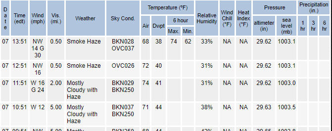
Syracuse, looks like visibility is actually 1/2 mile: National Weather Service : Observed Weather for past 3 Days : Syracuse, Syracuse Hancock International Airport
-
Why is dense smoke advisory criteria so much lower in the east than the west? In the western US, they routinely issue dense smoke advisories for 1-3 mile visibility, yet there are none issued even for less than one mile visibilities in the eastern US.
-
Central PA Spring 2023
TheClimateChanger replied to Itstrainingtime's topic in Upstate New York/Pennsylvania
Unfortunately, the next two days look just as bad as today. Tomorrow looks to be the worst, maybe a slight reprieve on Thursday. Of course, that's contingent on additional fires not breaking out between now and then inserting additional smoke. I don't know what the weather is like in Quebec, presumably dry. But there have been bouts of pyrocumulonimbus in recent days, which can be accompanied by dry lightning. Near surface smoke at 5 pm on Wednesday: Near surface smoke at 5 pm on Thursday: -
Central PA Spring 2023
TheClimateChanger replied to Itstrainingtime's topic in Upstate New York/Pennsylvania
While we've unfortunately grown accustomed to these extreme wildfire smoke events in recent years, in 1950, it was without precedence. 911 dispatchers were flooded with calls. Many ascribed various theories ranging from the end of the world, atomic bombs, flying saucers, toxic clouds from government experiments, to a non-forecast solar eclipse. From the Weather Bureau's Pennsylvania Monthly Weather Review for September 1950: -
Central PA Spring 2023
TheClimateChanger replied to Itstrainingtime's topic in Upstate New York/Pennsylvania
Interesting. The wildfire smoke last month prompted me to do some research. I wanted to see how unusual it was to have wildfire smoke, and what effects wildfire smoke has on the weather and climate. I came across a peculiar event on September 24, 1950 known as "Black Sunday" or "The Great Smoke Pall of 1950." Here is the article from Hazleton from that event: -
Arctic Sea Ice Extent, Area, and Volume
TheClimateChanger replied to ORH_wxman's topic in Climate Change
I mean, it's not ideal. But when the alternative is a guaranteed blue ocean event and the permanent loss of the Arctic as we know it, what other choice do we have? -
Central PA Spring 2023
TheClimateChanger replied to Itstrainingtime's topic in Upstate New York/Pennsylvania
Wow, this is an impressive pall of smoke tomorrow - keeps intensifying on the models. Which makes sense the earlier runs saw only the existing fires, and didn't factor in additional fires breaking out in the extreme conditions today. Now showing a widespread area of dense smoke with surface visibilities under a mile, perhaps locally under 1/2 of a mile. Looks like a potentially dangerous situation on portions of the New York State thruway. -
Arctic Sea Ice Extent, Area, and Volume
TheClimateChanger replied to ORH_wxman's topic in Climate Change
I see a lot of media reporting this as "it's too late to save Arctic summer ice." I'm not so sure. I think a targeted system of solar radiation management by spraying aerosols in the atmosphere over the Arctic each summer could buy us sufficient time to draw down GHG levels. But none of our do-nothing politicians want to have that discussion! -
Doubtful, likely a net negative. Cools the surface, and warms the upper atmosphere, which reduces instability. The presence of wildfire smoke does brighten and thicken cumulus clouds, producing additional cooling; however, the presence of more, but smaller, droplets means the resulting clouds are actually less conducive to rainfall. There is some research, however, that suggests wildfire smoke and aerosols can lead to more lightning - particularly dangerous positively charged bolts. If anything, the case can be made that the unusually smoky atmosphere contributed to the ongoing regional dry spell. https://www.nationalgeographic.com/environment/article/wildfire-smoke-is-transforming-clouds-making-rainfall-less-likely#:~:text=It does indeed%2C according to,likely to fall as rain. https://news.mit.edu/1998/smoke-1007
-
Pittsburgh/Western PA Summer 2023
TheClimateChanger replied to Ahoff's topic in Upstate New York/Pennsylvania
No strawberry picking this year at Soergel’s due to the drought: https://www.wpxi.com/news/local/soergel-orchards-wexford-cancels-strawberry-festival/YA3HKTJRZBHZ5CMAHELYFDX42Q/ -
Latest run of the HRRR suggests an intense plume of smoke settles in tomorrow to New York and Pennsylvania, both aloft and with a significant near surface component. Surface visibility is forecast to drop to one mile at times. If this is correct, I would expect near record-breaking levels of air pollution.
-
Central PA Spring 2023
TheClimateChanger replied to Itstrainingtime's topic in Upstate New York/Pennsylvania
The latest HRRR suggests a plume of extremely dense smoke is going to settle into New York and Pennsylvania tomorrow. The smoke will be both aloft and at the surface, with forecast surface visibilities of 1-3 miles tomorrow afternoon. I wonder if we will see the issuance of dense smoke advisories due to the visibility restriction? -
Looks like a very intense plume of smoke possible from Cleveland to Buffalo Wednesday morning. Total vertically integrated smoke concentrations in excess of 1500 mg per square meter. Some weird quirk in the wind patterns sends all of the smoke from the eastern Quebec fires west tomorrow during peak heating (diurnal peak of fire activity) where it mixes with the smoke from the fires in the west end of the province, and forms a dense pall.


