TheClimateChanger
-
Posts
4,574 -
Joined
-
Last visited
Content Type
Profiles
Blogs
Forums
American Weather
Media Demo
Store
Gallery
Everything posted by TheClimateChanger
-
Central PA Summer 2023
TheClimateChanger replied to canderson's topic in Upstate New York/Pennsylvania
Oh, accidentally deleted the original post. Just showing the means at various sites in Pennsylvania, for the first 13 days of the month. Our cool summer has come to a fiery end. So much for all the long range models showing cool weather. This humidity has been relentless. -
Central PA Summer 2023
TheClimateChanger replied to canderson's topic in Upstate New York/Pennsylvania
Confirmed. By average minimum temperature, it's been 10th warmest (of 129 years) at IPT, 8th warmest (of 136 years) at MDT, 4th warmest (of 58 years) at DUJ, and 5th warmest (of 65 years) at BFD. -
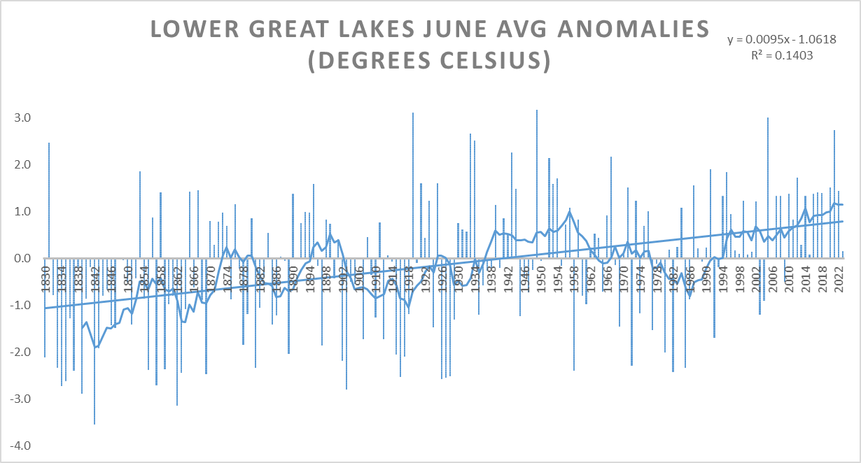
Interesting. Here is my best guess for the lower Great Lakes, using 7 reference sites. Data before 1860 is limited, and subject to larger deviation from actual. Edit: Corrected error in data for 1857 and added 8th reference site. Top 5 Coldest: 1. 1842; 2. 1862; 3. 1839; 4. 1903; 5T. 1834; 5T. 1857 Top 5 Warmest: 1. 1949; 2. 1919; 3. 2005; 4T. 2021; 4T. 1933 Comparing to NCEI rankings for 1895-present only: Top 5 Coldest: 1. 1903; 2. 1926; 3T. 1927, 1916, and 1928 Top 5 Warmest: 1. 1949; 2. 1919; 3. 2005; 4T. 2021; 4T. 1933 For the entire Great Lakes basin, NCEI has: Top 5 Coldest: 1T. 1916 & 1926; 3. 1958; 4. 1928; 5T. 1915, 1917 & 1982 1903 is 8th coldest and 1927 is 9th coldest. My dataset has 1958 and 1982 tied for 6th coldest since 1895, and 1917 & 1915 tied for 11th coldest since 1895. Some variation, but this my dataset covers only a subset of the full GL basin. Top 5 Warmest: 1T. 1919 & 2005; 3. 1933; 4. 1949; 5. 2021 All match, except for order.
-
What data are used to generate these? June 1856 was not the warmest June on record in the Great Lakes. That is incorrect. Smithsonian records have mean temperatures of 68.0F at Chicago, 70.7F at Detroit, and 70.6F at Cleveland - and these are based on tri-daily measurements, which have a warm bias compared to the average of the maximum and minimum - particularly pervasive in early summer, when 7 am local solar time is hours after sunrise. That is not even close to years like 1919, 2005, 1933, and 1934. That has to be wrong. The more recent data looks similar to official government statistics, except that the most recent years appear to have been systematically cooled relative to the past - which makes little sense, considering most of the biases in the earlier data would result in a warming bias.
-
This is actually a misconception. Not only are the values smoothed and normalized, but advanced statistical tools are employed to take it into account changes in exposure, location, and trends. For example, the 1991-2020 30-year average monthly mean for ORD in July is 74.6F; however, the 1991-2020 normal is 75.4F. The latter number is much closer to the current 15-year (2008-2022) running average of 75.3F. A "normal" July would actually be 0.8F warmer than the average from 1991-2020. Similarly, the 1991-2020 30-year average monthly mean for CLE in July is 73.6F; however, the official 1991-2020 normal is 74.5F. The latter number is exactly even with the current 15-year (2008-2022) running average of 74.5F. A "normal" July is 0.9F warmer than a simple arithmetic mean.
-
Pittsburgh/Western PA Summer 2023
TheClimateChanger replied to Ahoff's topic in Upstate New York/Pennsylvania
Overperformed on the highs today. Reached 90 at both Zanesville & Morgantown. Forecast showed a 0% and 6% chance of that occurring.
-
Chicago Weather Records Tracking
TheClimateChanger replied to Chicago Storm's topic in Lakes/Ohio Valley
Chicago was also a bit drier in the past, particularly from April through August. The current normal is just shy of 5" more than the old MDW norms, with the bulk of the difference occurring in the warm season. I thought maybe it was because MDW is simply drier than ORD, but NowData shows a normal annual precipitation of 40.88" for MDW. -
Chicago Weather Records Tracking
TheClimateChanger replied to Chicago Storm's topic in Lakes/Ohio Valley
Doesn't strike me as particularly warm outside of December and March, certainly nothing crazy. November 1877 December 1877 January 1878 February 1878 March 1878


-
Chicago Weather Records Tracking
TheClimateChanger replied to Chicago Storm's topic in Lakes/Ohio Valley
On the whole, the 1800s were quite a bit colder. The official coldest yearly mean in Chicago history is 45.1F, from 1875. However, the mean temperature was 45F in 1855, 43F in 1856, 44F in 1857, 44.9F in 1860, 45.1 in 1862, 44.3F in 1863, 42.5F in 1864, and 44.3F in 1865, according to records published by the United States Weather Bureau in 1947. The normals for 1947, which at that time were based on the 50-year period from 1878-1927, adjusted to airport exposure, are given below. The normal temperature for December was 26.9F, for January 22.3F, for February 24.9F, and for March 34.5F. By comparison, the current normals for O'Hare are: December, 30.5F; January, 25.2F; February, 28.8F; and March, 39.0F. These values are 3.6F, 2.9F, 3.9F, and 4.5F warmer than the reported 1947 Midway norms. -
Chicago Weather Records Tracking
TheClimateChanger replied to Chicago Storm's topic in Lakes/Ohio Valley
They used to post excellent comparative data in the annual and monthly summaries. It looks like the downtown business district was about 2-2.5F warmer than MDW in the 1940s in general in the wintertime. Below is 1947, by way of example. It says the city was 32.5F in January 1947, but I calculate the mean to be 31.1F. Using my corrected mean, the courthouse site was 2.4F warmer than MDW and 1.5F warmer than the University of Chicago in January 1947. In February, it was 2.0F warmer than MDW and 1.4F warmer than the University of Chicago. In December, it was 2.2F warmer than MDW and 1.0F warmer than the University of Chicago. For the annual means, the differences were much smaller... 1.1F warmer than MDW and 0.8F warmer than the University of Chicago. Annual mean maximum temperature was actually 1.5F cooler than MDW, but the mean minimum temperature was 3.8F warmer.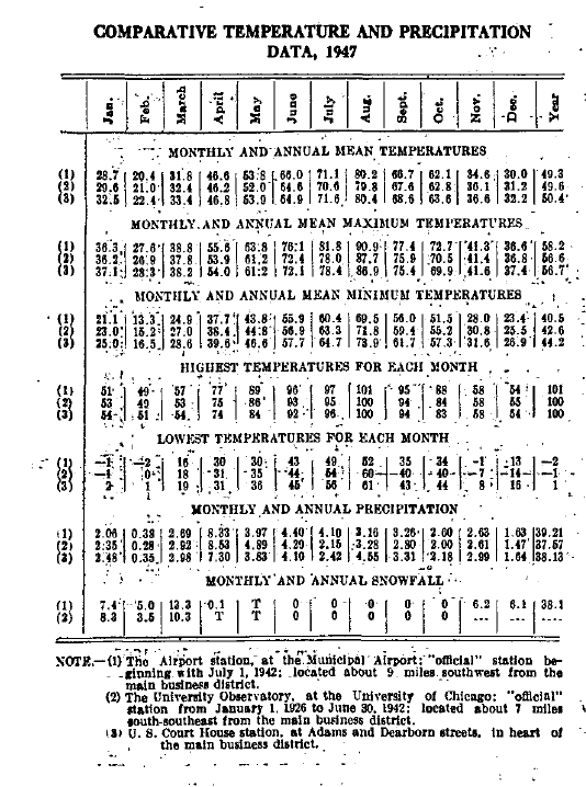
-
Pittsburgh/Western PA Summer 2023
TheClimateChanger replied to Ahoff's topic in Upstate New York/Pennsylvania
Looks like it could just be the use of different data. The monthly outlooks appear to rely on data from certain sources. The week 3-4 outlooks appear to have more human input. Based on this discussion, it looks like a cooler and wetter second half of July, with periods of smoke and haze from Canadian wildfires. Prognostic Discussion for Week 3-4 Temperature and Experimental Precipitation Outlooks NWS Climate Prediction Center College Park MD 300PM EDT Fri Jun 30 2023 Week 3-4 Forecast Discussion Valid Sat Jul 15 2023-Fri Jul 28 2023 This Week 3-4 temperature and precipitation outlook is for the period of July 15 - July 28, 2023, which is climatologically near the warmest two-week period of the year for much of the United States. June has been characterized by a tripole pattern of temperatures across the contiguous U.S. (CONUS): 1) record warmth in the southern CONUS, particularly in Texas, 2) below normal temperatures in the middle tier of states from California to the East Coast, and 3) above normal temperatures from the Pacific Northwest to the Great Lakes. This pattern is largely consistent with the weak teleconnection that is associated with El Niño during summer, which consists of zonally-elongated troughing of 500-hPa heights across the middle of CONUS with anomalous ridging both to the north and the south. Currently, Niño 3.4 sea surface temperature (SST) anomalies exceed +0.9 degree C, thus El Niño may continue to act as a weak background forcing. In fact, the Climate Prediction Center's (CPC) current Week 2 outlook is remarkably consistent with a weak El Niño teleconnection persisting. Other physical drivers considered for this outlook include the Madden Julian Oscillation (MJO), extratropical SSTs, soil moisture, the North Atlantic Oscillation (NAO), the Pacific-North American pattern (PNA), the long-term trend, and the ongoing Canadian wildfires. The Real-time Multivariate MJO (RMM) indices are currently weak, and they are forecasted to remain so over the coming weeks, with no coherent propagating signal. Thus, the MJO is not expected to have a meaningful impact on the Week 3-4 circulation pattern. Extratropical SSTs are below normal along the southern Alaska coast and the West Coast. They are above normal in the Gulf of Mexico and along the East Coast. The greatest soil moisture anomalies currently reside in the Mid-Mississippi River Valley, where much of the region is below the 10th percentile of climatology. However, conditions are likely to improve there as the current Weather Prediction Center's (WPC) quantitative precipitation forecast shows much of the region receiving 2 to 4” of rain over the coming week. The NAO is forecast to remain negative through Week 2, while the PNA is forecasted to be neutral. However, dynamical model guidance for Week 3-4 indicates that the NAO may persist in its negative phase while the PNA may trend toward positive values. These phases of NAO and PNA would increase the chances for troughing over eastern CONUS. With respect to the long-term trend, it is toward warmer temperatures across all of CONUS and Alaska. Finally, the Canadian wildfires have been a permanent fixture this summer. Smoke from these fires has intruded into CONUS regularly under anomalous northwesterly flow. Hazy skies produced by smoke generally reflect insolation, decreasing day time highs slightly. However, at night, smoke is a relatively inefficient longwave absorber/re-emitter and thus has little impact on nighttime lows. Therefore, the overall impact of the smoke is to lower temperatures slightly. The Week 3-4 temperature and precipitation outlooks take into consideration the El Niño teleconnection, the aforementioned physical drivers, and a blend of dynamical model guidance from the European Centre for Medium-Range Weather Forecasts (ECMWF), Climate Forecast System version 2 (CFSv2), Japan Meteorological Agency (JMA), and, to a lesser extent, the The Global Ensemble Forecast System version 12 (GEFSv12). The GEFSv12 was an outlier with respect to the other models. The forecasted 500-hPa height anomalies indicate ridging centered over the Aleutians and broad positive anomalies over Canada and western CONUS. Some troughing is centered over the Great Lakes in Week 3 that relaxes toward neutral anomalies during Week 4. With respect to western CONUS, the positive height anomalies are largest in the Desert Southwest and are near zero in the Pacific Northwest during Week 3. This overall pattern resembles the tripole, El Niño-like teleconnection described above. For the temperature outlook, above normal temperatures are forecasted in the southern CONUS. The Desert Southwest has the highest probabilities of above normal temperatures, being located under the ridge. Moreover, some internal, experimental tools are showing elevated probabilities of excessive heat in the region. A broad region of weakly enhanced probabilities of below normal temperatures are indicated from South Dakota southward and eastward to the Ohio Valley and Great Lakes. While most model guidance forecasted near zero anomalies in this region, the eastern CONUS has consistently verified below normal this summer due to persistent northwesterly flow and possibly due to the dampening influence of smoke on daytime highs. The smoke and haze is likely to continue, as the anticipated ridging over Canada promotes conditions favorable to wildfires and also provides northwest flow that advects the smoke into the eastern CONUS. Above normal temperatures are favored in the extreme northern tier of CONUS, where the impact of any ridging in western Canada will be most felt. Finally, most guidance agrees on enhanced probabilities of below normal temperatures in southwestern Alaska under northerly flow and above normal temperatures in northeastern Alaska under westerly flow. With respect to precipitation, northerly flow due to the presence of upstream ridging over the Aleutians promotes below normal precipitation over southern Alaska and above normal precipitation in northern Alaska. Below normal precipitation is likely over the Desert Southwest, under the influence of ridging. Above normal precipitation is forecasted from the Northern Plains to the East Coast, consistent with anomalous upper-level cyclonic flow in the region. Finally, for Hawaii, the multi-model ensemble from the Subseasonal Prediction Experiment (SubX) shows the highest probabilities of above normal temperatures in the northwestern islands, consistent with observed SST gradient. Below normal precipitation is favored in the southeastern islands and above normal precipitation is favored in the northwestern islands. -
Really misleading about how cool it was, though. Climate report shows 3.1 degrees below normal, which makes it sound like it was a freezing month. But it would have only been 0.6F below normal in the 2000s or 0.8F below normal in the 1990s using the normals then in effect. They’ve inflated these “normals” so much it’s hard to compare to when we were younger.
-
Occasional Thoughts on Climate Change
TheClimateChanger replied to donsutherland1's topic in Climate Change
-
Occasional Thoughts on Climate Change
TheClimateChanger replied to donsutherland1's topic in Climate Change
-
Pittsburgh/Western PA Summer 2023
TheClimateChanger replied to Ahoff's topic in Upstate New York/Pennsylvania
Unbelievably heavy rain with these storms. -
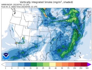
Saharan dust may be lower than usual, but a fair amount of Canadian smoke pushing south over the Gulf of Mexico and west Atlantic, as depicted on the HRRR and confirmed by satellite.
-
Central PA Summer 2023
TheClimateChanger replied to canderson's topic in Upstate New York/Pennsylvania
Interesting satellite imagery this morning. Smoke and haze of various thickness covering much of the territory, with a notable clearing over northwestern sections of Pennsylvania - seemingly adjacent to some of the thickest smoke. A large storm complex with high cloud tops casting a west/southwest shadow over southern Indiana and adjoining parts of Illinois, with a smaller area of storms over central Illinois. Smoke and haze banked up against the Smokies in eastern Tennessee, with an area of clearing along the mountains and immediately east of the mountains, although smoke and haze is filtering into North Carolina from the northeast. The smoke is not facing much resistance from the shorter Pennsylvania ridges, but a significant amount of terrain induced cloud cover can be noted paralleling the ridgetops. And what looks to be a massive burn scar is noted in the upper right hand corner along the border between Ontario and Quebec. -
As much as I like to blame climate change, I do wonder if some of this isn't being caused or exacerbated by arsonists and woke firefighting policies.
-
Not sure if this will come to fruition, but the Canadian smoke forecast model suggests a plume of hazardous air [250 ug/m3 PM2.5 = AQI of ~300] may affect parts of SNE tomorrow night.
-
I think what is particularly damning is the fact that Chicago O'Hare had 11 100+ days from 1986 to 1995, but only 6 such days since then, despite a rapid warming trend. Even the 1995 heat wave was likely exaggerated by equipment bias, which is one of the reasons Tom Karl cited as evidence there had been no systematic changes in extreme heat wave frequency: The 1995 Chicago Heat Wave on JSTOR And it's the same story in many places. Pittsburgh had 4 100+ days between 1986 and 1995 [2 in 1988, 1 in 1995], but zero since then. In fact, there has never been any other year other than 1988 and 1995 where KPIT [the airport] has reached 100 degrees, or better, dating back to the establishment of the airport in 1952.
-
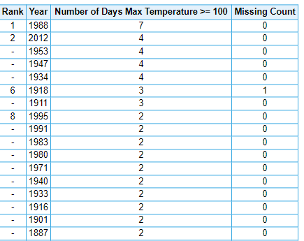
Officially, 1988 recorded the most 100+ days in Chicago weather history. But can we really say without a doubt this is a legitimate record, given the overwhelming evidence of bias in the HO-83 from various parts of the country which I cite to in the preceding post? Most likely, at least a few of these 7 days would have been measured in the mid/upper 90s in the absence of the HO-83. For the record, 3 of the 7 days were exactly 100. A bias of even 1F would suggest those days were only 99F, but comparison studies have shown the bias was in excess of 2F on sunny, summertime days. And it's the same case throughout the midwest. Now, one could ask why years from this era don't show up as breaking more records if there was a significant warm bias. But the bias was generally 2F or less overall, except larger during sunny summer days [i.e., the types of days in abundance across the midwest and eastern US during the summer of 1988, and always present in Tuscon, AZ]. The warming that has occurred due to AGW is of much greater magnitude, and so many recent years have set numerous records despite being observed on "cooler" equipment. And I would point out that 1991 does show up as a very warm year in many locations, which may have been somewhat inflated at sites utilizing the HO-83.
-
I will probably face resistance for pointing this out, since some seem to always assume (without evidence, I might add) that past records were more reliable than modern ones. However, I believe is important to note that the temperature records from this era (roughly mid 1980s to mid 1990s) exhibit a warm bias at most first-order climate stations, due to the widespread use of HO-83 hygrothermometer. Temperature readings from the HO-83 have been shown to exhibit a large warm bias (especially with summertime maxima). ASOS units were installed nationwide in the 1990s, and generally read a couple to, in some cases, several degrees cooler than the HO-83. It is therefore likely that the HO-83 hygrothermometer was at least, in part, responsible for some of the many record high temperatures set in the summer of 1988. In sum, 1988 was certainly an extreme drought - by some measures, the worst nationally since the Dust Bowl. The drought was accompanied by periods of extreme heat, although mean temperatures from that summer have been regularly exceeded in numerous recent years. Some of the records set at first-order sites from that summer are likely unreliable, since the equipment used to measure the temperature exhibited a warming bias of a few to several degrees on sunny summer days, especially in the absence of significant wind. When comparing temperature records, it is important to be aware of potential biases. Based on the evidence, I believe it is highly unlikely that we would have observed as many 100 degree days in 1988 had modern equipment been in place. Sources: Comparison of records from Lincoln, NE, showing a warm bias of around 2F relative to ASOS, but up to 7F on certain days: https://repository.library.noaa.gov/view/noaa/30286/noaa_30286_DS1.pdf American Meteorological Society Journal article, highlighting warm bias in Albany, NY (1.2C error on sunny July days): Recent Maximum Temperature Anomalies at Albany, New York: Fact or Fiction? in: Bulletin of the American Meteorological Society Volume 74 Issue 2 (1993) (ametsoc.org) 1991 New York Times article detailing how the HO-83 produced dozens of phantom record high temperatures in Tuscon, AZ: In Tucson, It's Not the Heat, It's the Thermometers - The New York Times (nytimes.com) Steve McIntyre and Anthony Watts discussion of the problem from 2008: Inside the HO83 Hygrothermometer « Climate Audit Steve McIntyre discussion from 2007, with numerous citations: The HO-83 Hygro- thermometer « Climate Audit
-
Meanwhile, "unbelievably blue" skies were reported over Boalsburg, Pennsylvania on Sunday, but did not receive any media coverage, much to the chagrin of one well-known meteorologist.
-
As I projected on Friday, one of the most impactful intrusions of wildfire smoke is ongoing over the Midwest and Great Lakes, with visibilities locally reduced to less than one mile, and widespread unhealthy (or worse) air quality. At the same time, higher altitude smoke from the Canadian firestorms has crossed the Atlantic and is blocking out the sun over Portugal.
-
Pittsburgh/Western PA Summer 2023
TheClimateChanger replied to Ahoff's topic in Upstate New York/Pennsylvania
Lots of filthy air upstream slowly advecting into western Pennsylvania in the northwest flow.