Northof78
-
Posts
574 -
Joined
-
Last visited
Content Type
Profiles
Blogs
Forums
American Weather
Media Demo
Store
Gallery
Everything posted by Northof78
-
We are within 1.5 days...wake up on Monday and enjoy your 2" - 4"
-
Models honing in at least a 2-4" storm, but very close to a biggie
-
NAM welll north too….looks like a 2-4” storm for many of us…
-
Tomorrow will mark 21 days (3 weeks) of straight snow cover across most of the region. Currently it appears likely we will hit the full straight 1 month mark by next weekend with cold temperatures remaining and some chance of additional snows in the period. Fairly rare for N/C NJ and NYC Metro, we get a 1 month (or more) straight of snow cover roughly every 5/6 winters.
-
I would not sleep on Wednesday's system, if I had to make a bet, I would say at least 1-3" is likely...looks pretty favorable in terms of heights building, storm track and cold air...
-
The GFS run looks brutally cold through Feb 15th...not sure we get a day above freezing through the entire run.
-
 Looks like many in the area are now near their total seasonal average save immediate NYC.
 -
GFS ensembles or other?
-
Light snow now
-
I can almost guarantee with a title of 'Its coming' 6 days out, it ain't coming ;-)
-
Yeah, that guy always go rogue...I'm within 5-6 miles NW of Elizabeth and had 11"
-
Is it just me, or the radar in PA looking decent for some light snow later this morning/afternoon, maybe a coating to 0.5" later?
-
I am going with 11.4" based on nearby reports, tough to measure exactly with lots of sleet/compaction, etc. but 11.4" for Millburn, SW Essex, and that leaves me at 29.5" on the season (basically normal for an entire season)
-
Never a bad thing to hit your seasonal average in January....
-
Almost fully converted to coastal, as primary falling apart....
-
Best forecast for almost all NY Metro was 10" - 15", with frankly a gradual increase from S to N, no huge cutoff, as for those who stayed all snow looks as ratios came down some. Places in C NJ have 10" - 12", NYC 11", NE NJ 11" - 14", NW NJ 12" - 15"
-
11.2" was last night's free market bet, looks to be within an inch either side....not bad
-
Roughly 9” and sleet
-
PHL still mod/heavy snow with 0.5 mile vis at 12PM
-
Very heavy snow now, probably 1.5" - 2"/hr stuff with dense large fluffy flakes
-
DC area keeps switching back and forth from sleet to snow (somewhat rate depending), still reporting luhht snow with 0.5" vis as of 10AM
-
Friend in N MD already has 9" with heavy snow (roughly 1.5"/hr.) And NAM gave him a storm total of 5"....
-
Solid light snow, dusting
-
14F / -9F ,Mostly Cloudy, light north winds
-
Extreme Cold, Snow & Sleet: SECS 1/24 - 1/26
Northof78 replied to TriPol's topic in New York City Metro
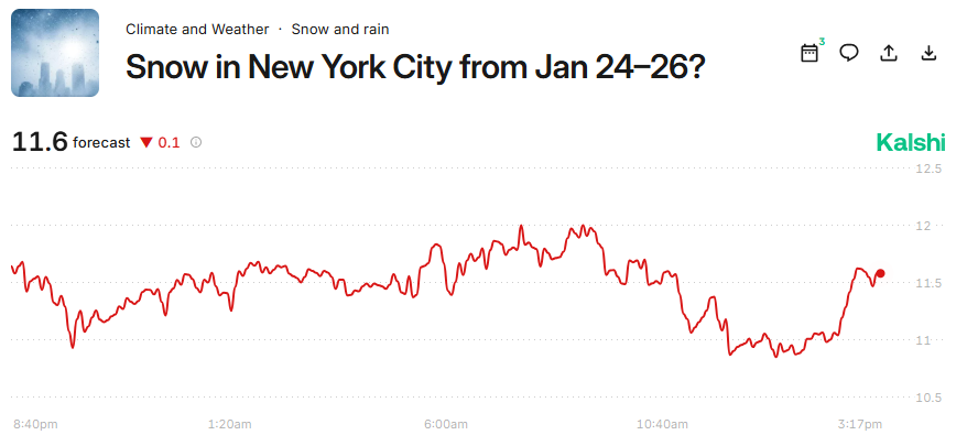
Betting markets (smart money) likes the 18Z NAM for an additional 0.6" inches vs. prior to run, for an over/under for CPK is now 11.6" for the storm.