Ephesians2
-
Posts
559 -
Joined
Content Type
Profiles
Blogs
Forums
American Weather
Media Demo
Store
Gallery
Everything posted by Ephesians2
-
Yep, not as much as last night but some accretion on elevated surfaces here. Sitting at 29, 3 degrees colder than NWS hourly forecast
-
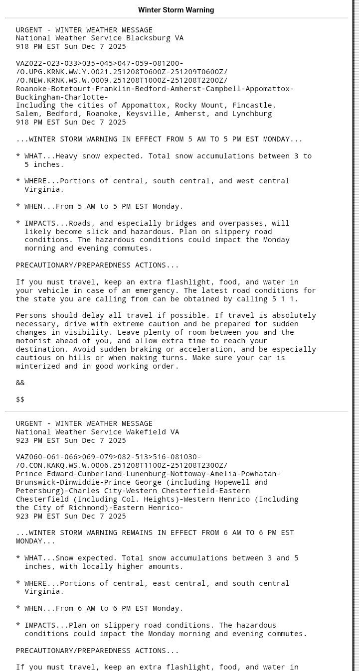
WSWs just dropped for VA from Roanoke to RIC

-
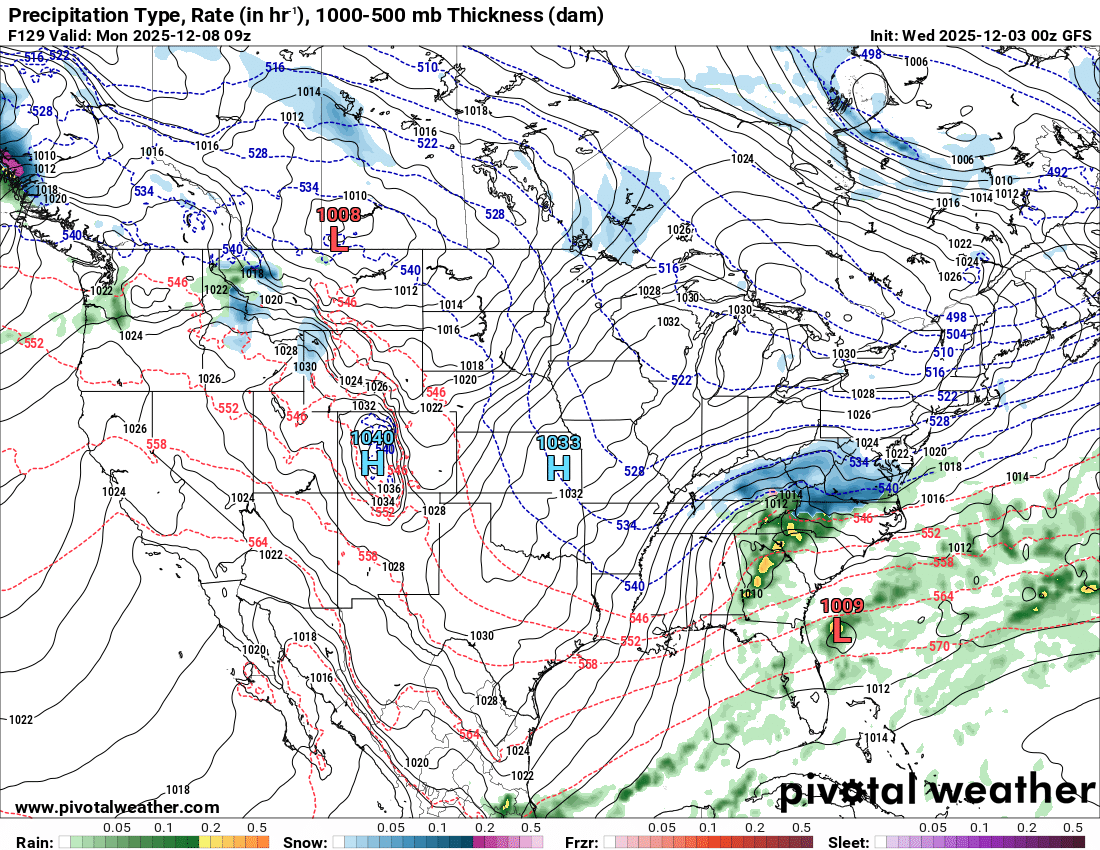
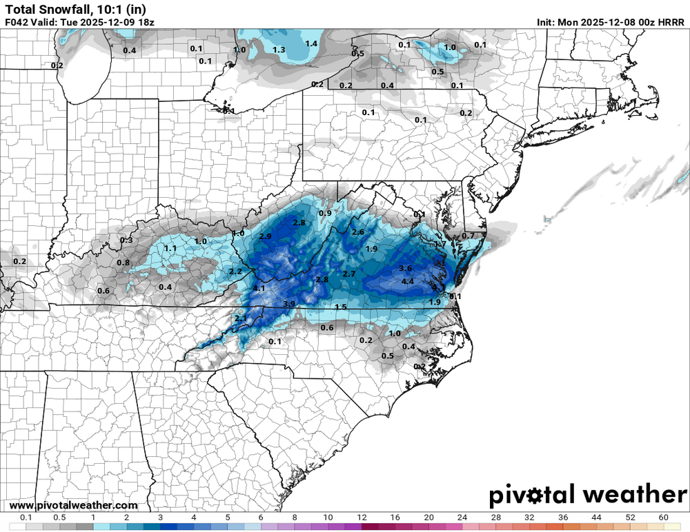
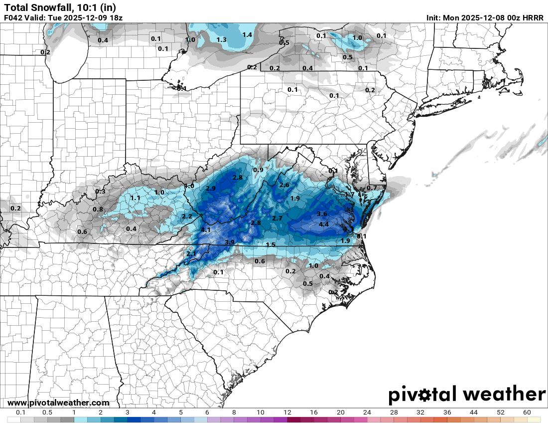
0z HRRR - a bit of an increase overall from 18z but like the NAM and 3k especially in the south side of the RIC metro
-
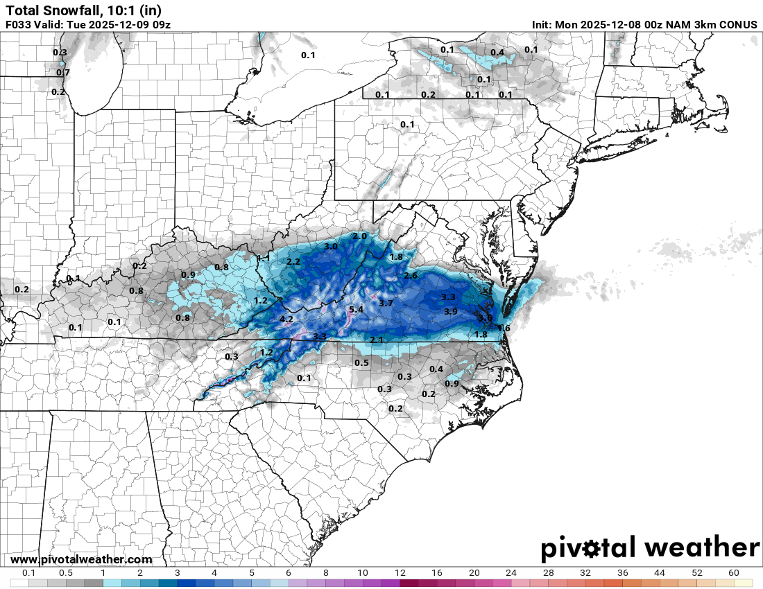
3k NAM is lighter with precip but still a step up from 18z.

-
Also, we have to give the ICON a lot of credit on this one. There were a few runs a couple days ago where it was the ONLY model showing accumulating snow.
-
Central VA generally doesn't do well with anything other than an already developed low moving into cold air. For example, the second Feb 2010 storm was either a total whiff or a light event here. That's why I'd, based on pure semi-educated guess, lean towards a lower total. The precip has to develop mostly over us due to the coastal/ULL. I'd love to be proven wrong though lol
-
00z NAM is going to absolutely pummel RIC especially south side of RIC metro. It also keeps precip around for longer
-
That's awful. I really don't have the words to say, except that our family will be praying for your wife and yourself as well.
-
Local Lynchburg meteorologists as well as the Blacksburg NWS are staying pretty conservative (all are saying 1-3). Interestingly Richmond meteorologists and the Wakefield NWS have higher totals which leads to the weird cutoff with watches versus advisories and in the NWS snow maps. Of course a 1-3" deal still could happen and honestly its my gut feeling, but if the Euro is right, a lot of people will be very surprised tomorrow and there could be quite a mess in Lynchburg/Roanoke.
-
The last few years have just been very paltry everywhere, so there's more random variation with one or two storms versus six or seven. Lower numbers = higher standard deviation. Like in 2011- 2012, Central Virginia got a random storm that dropped 4-8" and ended up with more snow than DC/Baltimore. That was the only snow that winter. If we're moving back into a more favorable climo, we will go back to a more normal regional distribution.
-
Love your posts. What do you think about the Euro? Seems like an outlier (and to a lesser extent the NAM 3k) in holding to a relatively weak storm that doesn't bring accumulating snow outside of the Smokies and eastern NC? What are the differences between the way the Euro develops the system and the GFS/Canadian/ICON/HRRR? I imagine it's a stronger trough over New England and/or a weaker shortwave?
-
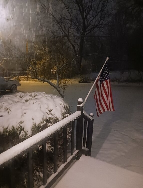
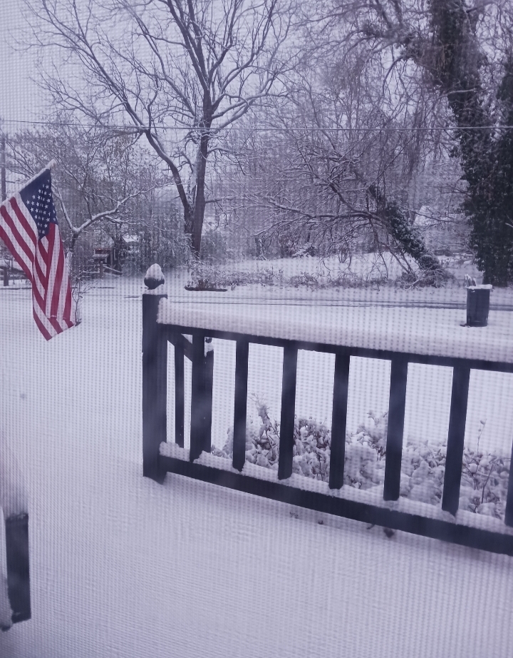
Lynchburg, VA 12.05.2025 - 3.4" Total 3.4"
-
Just measured 3 inches exactly. Grass is covered and still have some light snow.

-
2.2"
-

-

Richmond Metro/Hampton Roads Area Discussion
Ephesians2 replied to RIC Airport's topic in Mid Atlantic
OK, that's enough. No more north shifts lol -
Richmond Metro/Hampton Roads Area Discussion
Ephesians2 replied to RIC Airport's topic in Mid Atlantic
Big Improvement on the Canadian for Monday
.thumb.png.6259b803be20d030cac7a37b2696f666.png)
-
The CMC looks a lot closer for the Monday potential, as in it is not completely out to sea anymore
-
It seems to have a stronger storm and less positively tilted trough, but also trended way south with the confluence over eastern Canada/New England
-
Richmond Metro/Hampton Roads Area Discussion
Ephesians2 replied to RIC Airport's topic in Mid Atlantic
Actually looks like the jackpot's going to be in North Carolina with moderate snow into Central VA, which doesn't seem like a terrible situation to be in at this range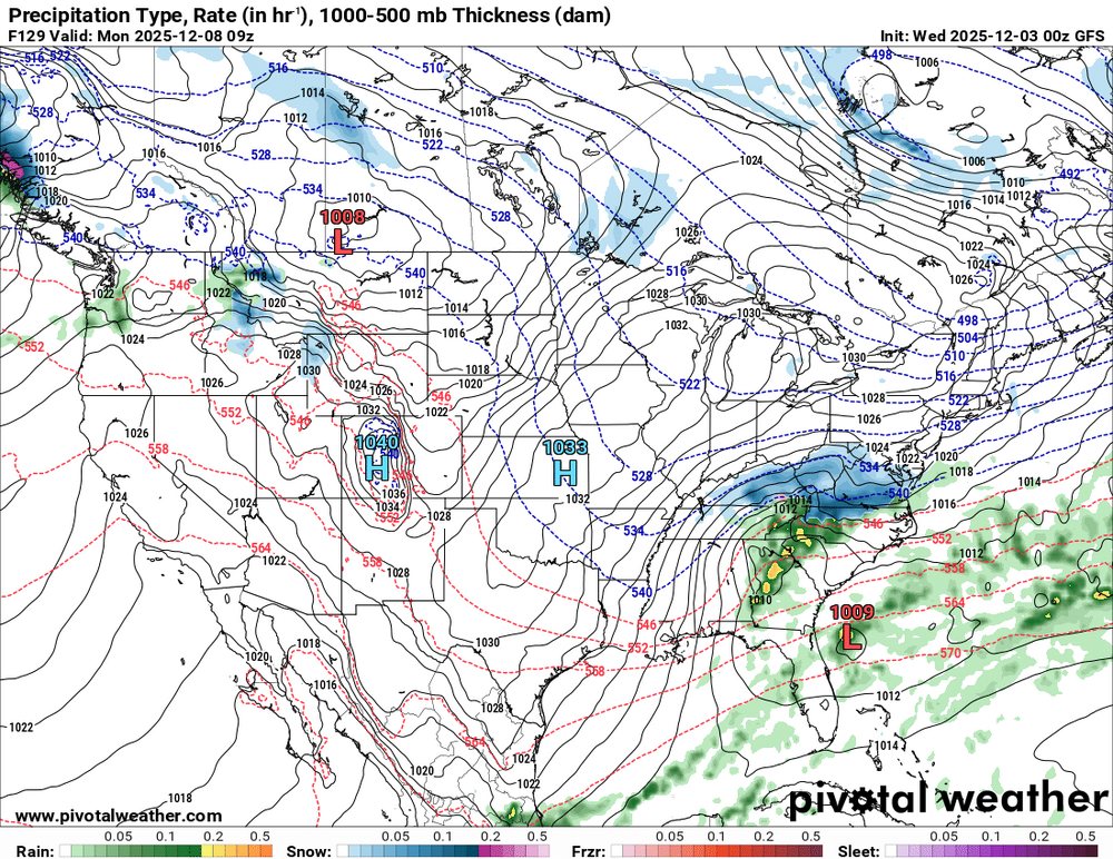
-
CMC noticeably north again. Northern edge of the precip shield in Central VA vs NC last run
-
CMC made a substantial shift north with the Friday event. It still isn't close enough for anyone on this forum, but it's only about 100 miles away from a hit versus 400 miles
-
FWIW dropped to 31 degrees here, which although it seems to be partially local/microclimate related, it is lower than forecast. Blacksburg seems to think the cold overperforms as well (most models have all rain) Hope the DC area gets an overperformer! Not much chance down here though

-
DCA: -1.5 NYC: -1.0 BOS: -1.5 ORD: -2.5 ATL: 0.5 IAH: 1.5 DEN: 2.0 PHX: 4.0 SEA: 3.0
-
I didn't realize the SOI was positive or neutral in 2023-24 except for in January. What a weird winter.


.png.b14a690fe92d65b740a52c83b98b7e89.png)