Ephesians2
-
Posts
559 -
Joined
Content Type
Profiles
Blogs
Forums
American Weather
Media Demo
Store
Gallery
Everything posted by Ephesians2
-
RNK's map had you starting at 3-5 and me at 5-7. Looks like precip is moving in more quickly than anticipated.
-
37/7 in Lynchburg. Clouds thickening to the West.
-

Richmond Metro/Hampton Roads Area Discussion
Ephesians2 replied to RIC Airport's topic in Mid Atlantic
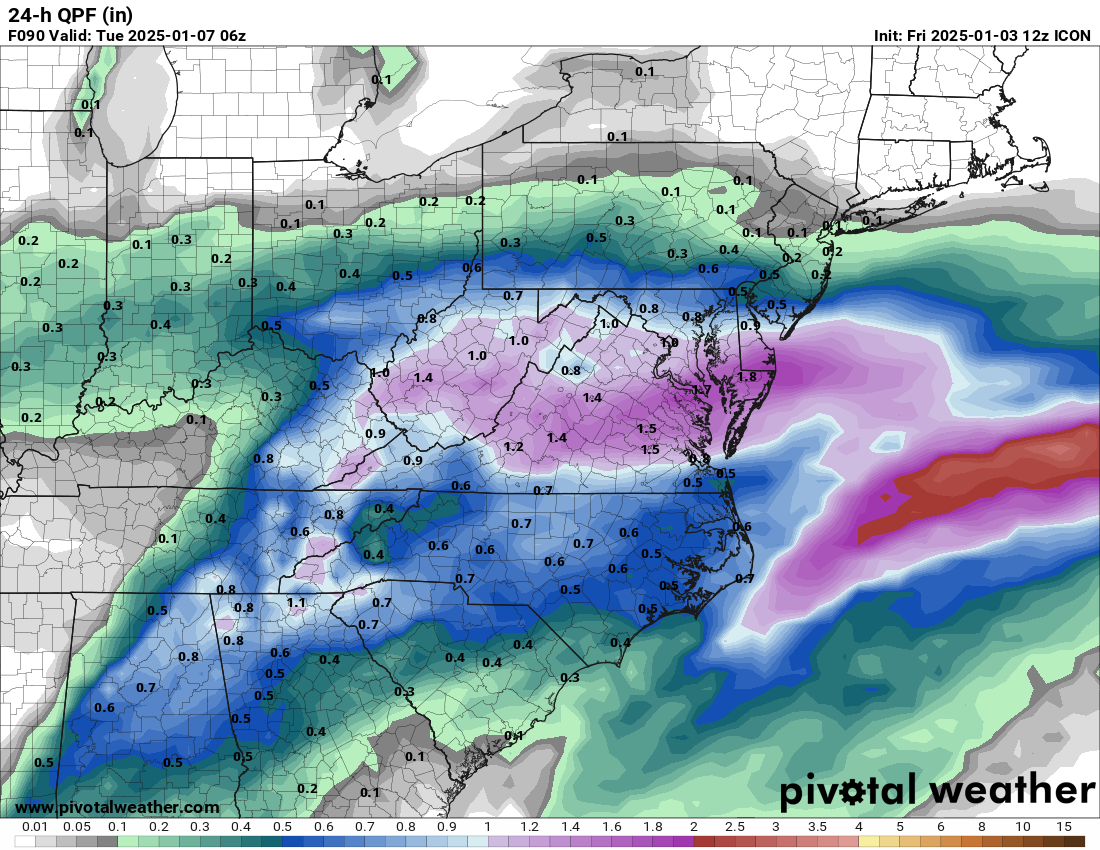
Huge divergence between NAM and HRRR QPF for Central VA. NAM cut QPF in half versus its last run. -
Richmond Metro/Hampton Roads Area Discussion
Ephesians2 replied to RIC Airport's topic in Mid Atlantic
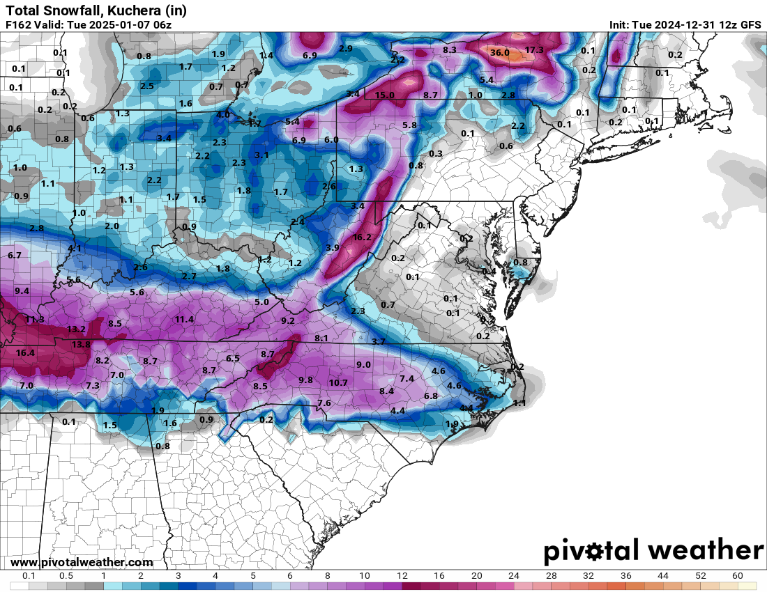
RGEM ticks to the south and bumps up QPF - 11.1" at RIC on Kuchera. It's a tight gradient just south of there though. -
Richmond Metro/Hampton Roads Area Discussion
Ephesians2 replied to RIC Airport's topic in Mid Atlantic
NAM was showing basically nothing 24 hours ago, right? Also, from what I've heard it tends to have a north bias. I think it's an improvement and definitely better than where we thought it be going a couple of days ago. 2-4" with some sleet and ZR will stick around a while with the advertised temperatures. I got 4" with the second Jan 2022 storm, including an inch of sleet, and it stuck around for two weeks with warmer temperatures than what we are seeing on models. -
Jan 2019 seems the closest, at least that I can think of. https://www.stmweather.com/blog/current-events/winter-storm-january-11-13-2019
-
January Medium/Long Range: A snowy January ahead?
Ephesians2 replied to mappy's topic in Mid Atlantic
I was in Fredericksburg for Jan 2022 and got 15". Other than that, the only 10"+ storm I remember clearly is the 2016 blizzard. I have very vague glimpses of the 2009-2010 winter despite being 7 years old then, because I was a weather nerd, my parents got me a 3-year weather observation book for my 7th birthday -
Richmond Metro/Hampton Roads Area Discussion
Ephesians2 replied to RIC Airport's topic in Mid Atlantic
CMC is a step in the right direction as well. Confluence further south. Snow jackpot and QPF max now over Fredericksburg, not DC. Verbatim, not exactly what we want in Central VA, but it's an improvement - the 6" line is roughly from Charlottesville to Hanover County. I'm liking these trends. -
Richmond Metro/Hampton Roads Area Discussion
Ephesians2 replied to RIC Airport's topic in Mid Atlantic
GFS went slightly south. Not exactly where we want it - but an appreciable shift. -
Richmond Metro/Hampton Roads Area Discussion
Ephesians2 replied to RIC Airport's topic in Mid Atlantic
FWIW ... map from local Lynchburg TV meteorologists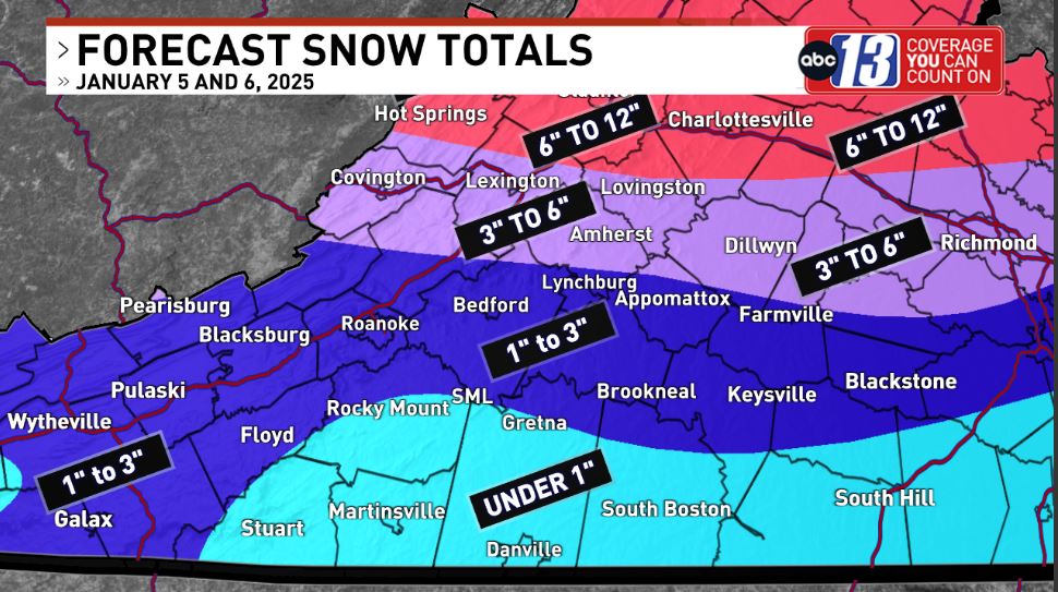
-
Richmond Metro/Hampton Roads Area Discussion
Ephesians2 replied to RIC Airport's topic in Mid Atlantic
The GFS does not cave. Going to be virtually identical to 12z. Also significantly drier than other models. -
Richmond Metro/Hampton Roads Area Discussion
Ephesians2 replied to RIC Airport's topic in Mid Atlantic
On the other hand, the RGEM looks like a *slight* step back, but basically unchanged (mostly sleet/ice with 1-3" in Central VA). It's a DC/NoVA jackpot with the 6" line near Fredericksburg -
Richmond Metro/Hampton Roads Area Discussion
Ephesians2 replied to RIC Airport's topic in Mid Atlantic
ICON is a significant improvement and gives Richmond area some snow from the Coastal as well.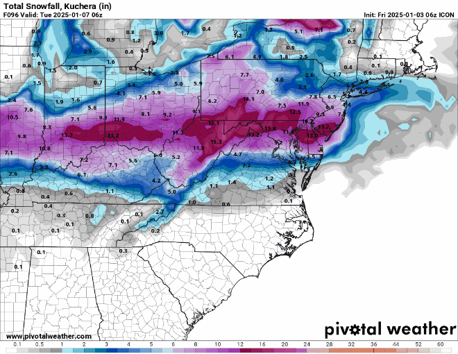
-
Richmond Metro/Hampton Roads Area Discussion
Ephesians2 replied to RIC Airport's topic in Mid Atlantic
NAM isn't great, but an improvement. It brings some snow into Central VA, but still mostly sleet/ZR. Hoping it's overamplified as I've heard its bias is. -
Just got a nice squall in Lynchburg - quick coating on grass and car tops. Not in the forecast from NWS or commercial sites.
-
Flurries in Lynchburg.
-
Richmond Metro/Hampton Roads Area Discussion
Ephesians2 replied to RIC Airport's topic in Mid Atlantic
-
Richmond Metro/Hampton Roads Area Discussion
Ephesians2 replied to RIC Airport's topic in Mid Atlantic
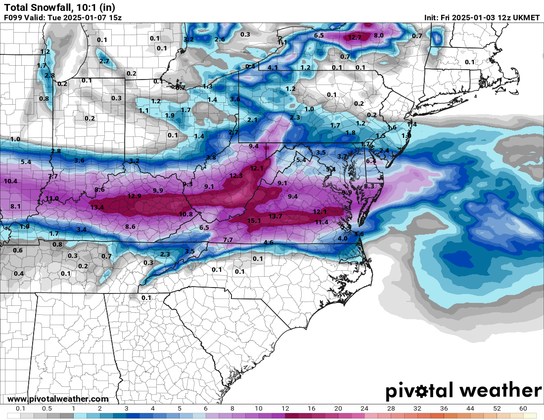
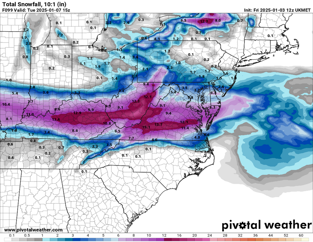
UKMET is beautiful - south of 00z. R/S line south of Richmond the whole event. -
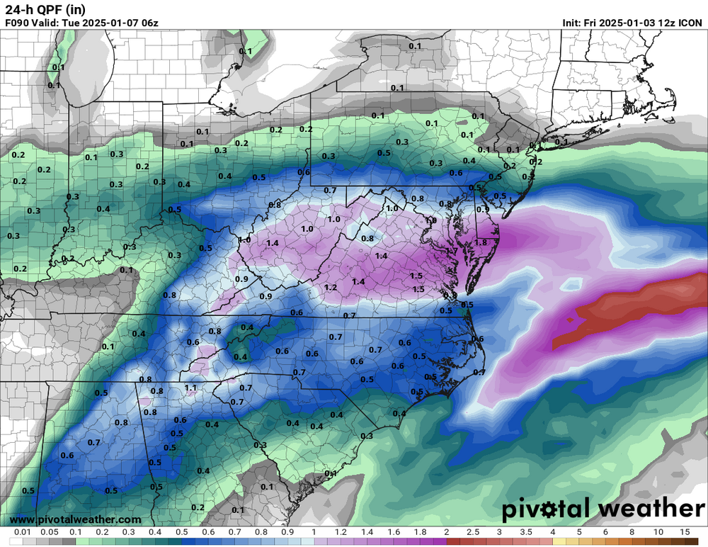
It looks like a very wet run as well. This would be a lot of sleet south of the immediate DC suburbs, and significant ice in Central VA
-
Richmond Metro/Hampton Roads Area Discussion
Ephesians2 replied to RIC Airport's topic in Mid Atlantic

-
I hope we can get a couple of inches of snow before the flip to ice. If so, it will definitely stick around a while.
-
Richmond Metro/Hampton Roads Area Discussion
Ephesians2 replied to RIC Airport's topic in Mid Atlantic
We did - it's going to be heaviest DC north. Verbatim - it's mostly an ice event in Central VA. -
Richmond Metro/Hampton Roads Area Discussion
Ephesians2 replied to RIC Airport's topic in Mid Atlantic
Let's hope we don't lose the GFS completely. -
Richmond Metro/Hampton Roads Area Discussion
Ephesians2 replied to RIC Airport's topic in Mid Atlantic
I don't want to post this in the main thread because they didn't like the run, but this doesn't look bad for Central Virginia at all with the standard medium/short-term north trend, and with other models like the ICON and Euro with the jackpot in DC area.
-
January: Medium/ Long Range: May the Force be with Us....
Ephesians2 replied to Weather Will's topic in Mid Atlantic
Looks like 1-3" with fairly marginal temperatures.