

MN Transplant
-
Posts
17,728 -
Joined
-
Last visited
Content Type
Profiles
Blogs
Forums
American Weather
Media Demo
Store
Gallery
Everything posted by MN Transplant
-
4”. Nice steady 1”/hr rate.
-
3.0”, >1”/hr rates. Zero wind. 28.6
-
29.1. 1 3/4”. This is going great.
-
He's been fighting sleet per earlier posts.
-
@mattie g It wasn't me!
-
I'm at 18 W/m2. It is done. 31.1 and a nice coating on all non-paved surfaces.
-
Huge win. Congrats!
-
More on track. I'm still thinking 5", with 6-7" being a good "reach" amount.
-
32.0. Lost very little precip cooling us down and now we are off and running.
-
32.5 and light snow. Everything looking good. Radar out of Charleston WV is nice.
-
And now we are at light snow. Nice quick transition.
-
I had to stare really hard, but I saw some flurries. 34.9 and soon to drop.
-
37/18 on the ob at DCA. 34.6 here. Almost completely irrelevant. mPING reports from Winchester and Front Royal, and even one in the last couple of minutes from The Plains along 66.
-
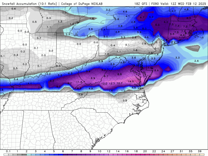
5” is a very realistic target for us
-
Parent NAM is an inch an hour from 4-10pm. Always fun to get a NAM’ing.
-
I consider the 12z HRRR to be a complete cave. 0.5” precip up to DC.
-
It is amazing that every model puts the heaviest axis of precip between Richmond and Fredericksburg, and the HRRR just insists that it’ll be Richmond and south.
-
Maybe no shock that the NAM over amps this one. 3k with 0.75” precip, which plays
-
Steady as she goes
-
Let’s be clear about the HRRR. There have only been 3 runs that take it to 6z Wednesday and 2 through 12z. The 06z run at 48 hours had 0.11” precip through 48 at DC. The current run has 0.40” through the same period.
-
Not that it matters, but the QPF around DC is 0.45”, which is about the RGEM/ICON/Ukie.
-
February 11-12; 12-13: Are they real??
MN Transplant replied to stormtracker's topic in Mid Atlantic
It is locked in. Can barely tell any difference in the precip fields from 00 to 06 to 12z. -
February 11-12; 12-13: Are they real??
MN Transplant replied to stormtracker's topic in Mid Atlantic
The HRRR is great - when it confirms what every other model is saying. -
February 11-12; 12-13: Are they real??
MN Transplant replied to stormtracker's topic in Mid Atlantic
Tight precip gradient around DC. Best from Fredericksburg east. -
February 11-12; 12-13: Are they real??
MN Transplant replied to stormtracker's topic in Mid Atlantic
It remains a 5-7” storm with the potential for a couple of inches upside in a small, tbd area. Nothing overnight changed that.


