

MN Transplant
-
Posts
17,817 -
Joined
-
Last visited
Content Type
Profiles
Blogs
Forums
American Weather
Media Demo
Store
Gallery
Everything posted by MN Transplant
-
Hadn’t been paying attention to the timing, but snow breaking out by morning Wednesday
-
Good consensus across the models of gusts at least in the 50-55mph range.
-
Kucera is rarely valid IMO. Stick with 10:1 unless there is something obvious.
-
We need a rule that if you post Kucera you have to post 10:1 too.
-
Wild map
-
Nobody is sleeping through that
-
I only got 0.2" from that, but it was still quite the event.
-
Gust to 56 at DCA and 53 at IAD. This is impressive.
-
It is loud. IAD to 51 mph.
-
12/24/24 0.1 1/3/25 0.3 1/5-1/6/25 7.7 1/11/25 1.0 1/16/25 0.1 1/19/25 0.8 2/11/25 6.3 24-25 Seasonal 16.3
-
6.3” on 0.73” precip. Not a great ratio, but a win anyway! Kudos to the NAM Nest for performing really well IMBY.
-
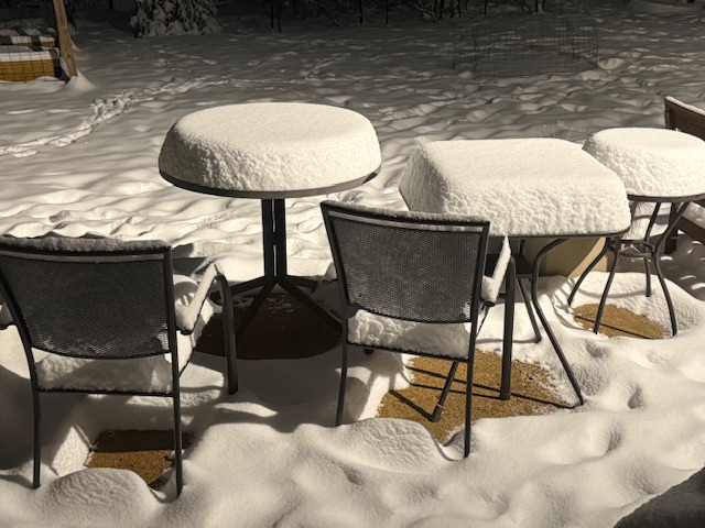
I’ll measure a bit later, but I’ll say that one oddity is that I’ve never had so much snow with absolutely no wind. The fact that there are clear patches under the table and chairs is amazing.
-
That is a depressing stat on a happy day!
-
Lightning or a transformer? Snow is sticking to the pine trees. 5 1/4” and modeling indicates about 2” more. That would be almost equivalent to last month’s event (7.7” here).
-
4”. Nice steady 1”/hr rate.
-
3.0”, >1”/hr rates. Zero wind. 28.6
-
29.1. 1 3/4”. This is going great.
-
He's been fighting sleet per earlier posts.
-
@mattie g It wasn't me!
-
I'm at 18 W/m2. It is done. 31.1 and a nice coating on all non-paved surfaces.
-
Huge win. Congrats!
-
More on track. I'm still thinking 5", with 6-7" being a good "reach" amount.
-
32.0. Lost very little precip cooling us down and now we are off and running.
-
32.5 and light snow. Everything looking good. Radar out of Charleston WV is nice.
-
And now we are at light snow. Nice quick transition.


