Stevo6899
-
Posts
2,925 -
Joined
-
Last visited
Content Type
Profiles
Blogs
Forums
American Weather
Media Demo
Store
Gallery
Everything posted by Stevo6899
-
Stackn Phatties along 696.
-
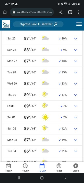
It will be interesting to see who will see more precip from dec-feb, fort myers or detroit. I have no idea historically who receives more precip. Having lived in Florida in the winters for awhile now and with it being their dry season, it'll be interesting if el nino follows through and its a wet winter. 2 seasons ago, I think it rained 2 days from christmas through february in fort myers. With that being said, I'd guess detroit sees more precip normally, but it'll be interesting if the tele's will have enough influence on the el nino enso and push that storm track further north so it's not another dull winter up north.
-
I looked this storm up early after seeing Josh mention it and it looked like a good storm for alot of areas but I don't recall it. I kept a close eye on snowstorms while I was in florida too. I'll take a Halloween snowstorm for sure. All I remember is rainstorms while I was young trick or treating lol.
-
He can't see your posts anymore. Consider that a sign that you may be trolling too hard as me and josh have been going back and forth for years and he's never put me on ignore... that I know of. While I do enjoy deep snow cover, and may be superstitious when it comes to getting a snowstorm on top of Snowcover, I'll take the warm swings and the risk of sleet if it means the potential for big snows. On the other side I don't mind arctic air if it leads to overachieving clippers, although when its below avg temp wise, clippers seem nonexistent nowadays with the bigger storms suppressed.
-
Yea as soon as I posted earlier today, I recalled a snowstorm we had around Nov 20, at least 6+ years ago. 2-4 was forecasted, 8-12 fell and I don't think we had another 6+ snowfall the rest of that winter. It's weird how history repeats itself when it comes to notable events.
-
While we have had warm winters lately and I have been living in Florida for them, I am back living in Michigan to take care of my parents and ready for a cold/snowy November. Per our climate, its normal to have to wait until early/mid December for a good snowstorm. I'm hoping we can switch and get into winter quickly. I just went for a bike ride and man what a shock to the system to go from 94/humid to 55 and dry. The sun sure does still feel good. I wonder what's more likely, a early November snowstorm, or the lions hosting a playoff game...
-
Looks like one of the nicest stretches of weather currently and upcoming. It was warm enough for the beach today and looks like 70 n sunny for atleast the next 7 days +. Can't remember the last time we had a soaking rain. Few weeks ago? I was thinking of doing some traveling since I am off work this month but when it's nice here, it seems kinda silly to travel. It would be nice to stay warm through October. I'm all for skipping fall and cold rain into straight winter.
-
Agreed. I think some are so spoiled with awesome tornado vids people post on here, that when there isn't a tornado outbreak, or a derecho with 100 mph winds, it's auto bust. 60+ mph winds and ping pong hail here is like an ef5 tornado in tornado alley. It'll only take 30+ yrs of living with ZZZzz weather for people to realize how today wasn't a bust.
-
There's been more severe action here in the northern/east of 75 burbs the past 10 days, than what seems like the last 10 years combined. As always, even with good parameters in place, weather can still be unpredictable, and underwhelming, especially in these parts. I think some get too caught up in the hype and then are quick to call bust when there isn't as big of an outbreak as modeled. Just like in the winter, gotta take what the models show with a grain of salt.
-

2023 Short/Medium Range Severe Weather Discussion
Stevo6899 replied to Chicago Storm's topic in Lakes/Ohio Valley
Probably the most intense storm I've seen here in the 32 yrs living in macomb. Easily gusts over 70 that lasted over 10 mins, close to ping ping size hail. Their wasn't much of a shelf cloud as it approached, which is usually my fav part lol. There's a huge evergreen tree next door that I've been meaning to get cut down for my parents as its west of the house. Luckily that didn't come down. -
As always different strokes, but I don't see the excitement watching cars drive in circles for hours. I could watch tornadoes go in circles for hours tho.
-
Lol nobody cares even more about what your prick ass says. Take your miserable, bullying ass somewhere else.
-
Lol @ flying off the rails. The worst I do is complain about the shitty cold rainy days. This is an open forum, not a classroom discussion. When I'm on here, you just always seem miserable and a dick towards someone for their posts. Anyone can be a dick behind a screen. I doubt you'd say a quarter of what you say on here to someone's face.
-
Stebo needs to star in a third grumpy old men movie. So grumpy the movie will just star him and not 2 grumpy guys. Ffsakes lighten up.
-
Yea I bitch, moan and complain like I'm in my 60's. Ill try to dial it back and be grateful its almost summer lol. Back issues runs deep in my family and since I've been golfing since I was 15, a daily runner/cyclist, it's just wear n tear. I had a spinal fusion 3 years ago and I think the back is finally 100%. These rainy/chilly days I definitely feel the stiffness in the back.
-
While I enjoy a good severe storm and snowstorms, I also enjoy warmth 12 months out of the year. When you've had 3 back surgeries, you appreciate the warmth. Ill be 37 next week and the cold is starting to affect my body/aches lol. Severe is hard to come by in metro detroit so i guess thats another reason why I want warmth asap. Ive been spoiled and fortunate enough to be able to kinda have both living in florida and fly back for snow. Looks like I'm gonna be home for awhile so it's all good. There really isn't a better place to be during the summer than the great lakes, up north, so ill enjoy it vs the humidity down south in the summer. Just over these overcast/rainy cold days.
-
Another one of those rain storms where you look at the radar and wonder why the deformation band never looks as good and as slow moving in the winter lol.
-
Different strokes. I'm OK with rain if it's warm. A warm april/march doesn't mean the summer will be hot. I was spoiled down in florida this winter. Temps were 85, 10 above normal almost everyday, and it rained like 2 times. Unfortunately Ive been back in detroit since march 26th for family issues, and i miss the everyday warmth/sun. I want all the heat. It makes me feel good. Looks like maybe 5 more days of garbage then hopefully the 60s and 70s are here to stay .
-
Yea I guess I just get excited when April comes, expecting consistent warmth which isn't the norm. It would just be nice to get a torch April or March, and that just hasn't happened in awhile.
-
Josh can prob verify as I usually talk outta my ass, albeit accurate often, and he has the real data, but this seems like the 5th shitty April in a row. Granted it was 80 n sunny for 5 days in a row, but other than that, 20 days of grey, shitty temps.
-
I'm all for severe weather out in open fields in Iowa, but I'll never understand why people want severe weather in their backyards and homes. As far as today goes, front sped up, less time for atmosphere to get juiced for metro detroit. It's always something on this side of the state for storms lol.
-
Areas in milwaukee/Illinois that just got a foot plus snowstorm, under tornado warnings. Still amazes me the swings in weather you see this time of year...
-
Some of better snows come in March due to warmer temps, more moisture return from south, unfortunately we never get em.
-
You're time to come is now, well in a few weeks or in january when less spring breakers. Man the amount of drunk drivers out last night in miami was scary. Def don't wanna come in the summer, but I guess you're used the instant sweat walking outta the house in dallas.
-
This was true about 5 years ago and ive been a snowbird for the last 5 and moved down to estero about a year ago. There's def all types down here, but there has been an infusion of younger people and families since covid. People are definitely nicer, happier than metro detroit. Its felt like the tropics this winter for sure. Also for those bitchn and moaning about the off topic talk, relax. Were 3 pages in and it's easy to follow along and ignore the florida talk. If this was a historic storm affecting more in here than I would agree take the florida banter elsehwere.