Stevo6899
-
Posts
2,925 -
Joined
-
Last visited
Content Type
Profiles
Blogs
Forums
American Weather
Media Demo
Store
Gallery
Everything posted by Stevo6899
-

Winter 2023/24 Medium/Long Range Discussion
Stevo6899 replied to Chicago Storm's topic in Lakes/Ohio Valley
I feel we talk about it every winter but that's about as nasty as I've seen it around here. Deep snow, arctic temps. I doubt we'll see that ever again. -
I guess I'm not around as much, but from what I saw he just liked to show off his love for warmth and palm trees. Nobody else in his life cared so he turned to here. I suppose not everyone has the tolerance to deal with trolls...
-
Winter 2023/24 Medium/Long Range Discussion
Stevo6899 replied to Chicago Storm's topic in Lakes/Ohio Valley
Yea suppression is always the worry in El nino. Obviously like you said, until that midweek system rolls through, who knows. -
Winter 2023/24 Medium/Long Range Discussion
Stevo6899 replied to Chicago Storm's topic in Lakes/Ohio Valley
Gfs looking like you may be onto something... -
It's a message board, not a workplace. Just ignore people that try to troll sometimes. Its not that hard. Not sure why we gotta threaten people on here.
-
Winter 2023/24 Medium/Long Range Discussion
Stevo6899 replied to Chicago Storm's topic in Lakes/Ohio Valley
I guess we got some stuff to track for awhile. As always all models showing drastically different things. Glad it's getting active... -
Yea central Missouri looks like the place to be. 12 hours+ of heavy deformation snow. Would be nice to witness something like that in my lifetime. Whoever gets under that banding, heaven...
-
Winter 2023/24 Medium/Long Range Discussion
Stevo6899 replied to Chicago Storm's topic in Lakes/Ohio Valley
I think that next storm, if it's as strong as depicted now, will go nw, just like next week's. We need a gulf low or something come out of south Texas. These lows that come outta the rockies/4 corners/panhandle go negative tilt too early for metro detroit to get in on the goods. -
Winter 2023/24 Medium/Long Range Discussion
Stevo6899 replied to Chicago Storm's topic in Lakes/Ohio Valley
Looking like areas east of Chicago, and west of Albany ny, Zzzzz. Typical corridor of mediocrity. -
Still large differences between the euro/Canadian. Barely any cold sector precip and storm is pretty progressive on the canadian. Uncle ukie has totals drop off significantly from south to north Illinois, cutoff around Chicago.
-
Yea looking good for western sub, hopefully the next one delivers for those who miss out on this one.
-
Yea I think with a low that strong, there will be more dynamic cooling that the models aren't portraying. A track from NE Arkansas to Cleveland is usually good for most of Michigan. Interesting to see the euro look more like earlier gfs runs and the latest gfs took a step towards the euro.
-
If the gfs ends up verifying, I'd imagine there would be blizzard warnings for the grr area. Only a few hour drive away. Canadian has a totally different evolution and track.
-
The point is that may be the only storm the past few winters that didn't end up weaker/se than what the euro depicted 4/5 days out. I think the fact that detroit had mixing issues is why I didnt recall that event.
-
Euro actually ends up weaker, but it ejects further north and gets its act together quicker than the gfs/cmc. Euro caved to the gfs numerous times last winter. I wonder who wins our first model battle this winter...
-
Canadian seems confused on where the low strenghtens. Not much cold sector precip. Definitely gonna be a Rollercoaster on the models the next few days.
-
I dunno, I was in florida and if there was anything of significance, I would've flown home. I doubt it was anything close to as strong as what models are depicting for this potential.
-
Most people don't pull out the shovels for flurries and tenths of snow on sidewalks.
-
It's been years since we've seen a nw trend or a storm actually strengthen to the degree the models are showing. Models have gotten tendencies to over amp storms so anything is on the table, from a sub 980 tracking over chicago to 990 tracking over pittsburgh. Either way this low pressure is impressive on satellite and causing high winds in alaska.
-
Normally I would be concerned about not having the euro on my side but the euro was really bad and overamped on several occasions the past few winters. We haven't seen a storm like this in years and the trend has been SE and not as wound up. With that being said, this has ghd written all over it and overdue for a nw trend/bomb like this. In a strong el nino winter, the last thing I thought I'd have to worry about is a low tracking overhead.
-
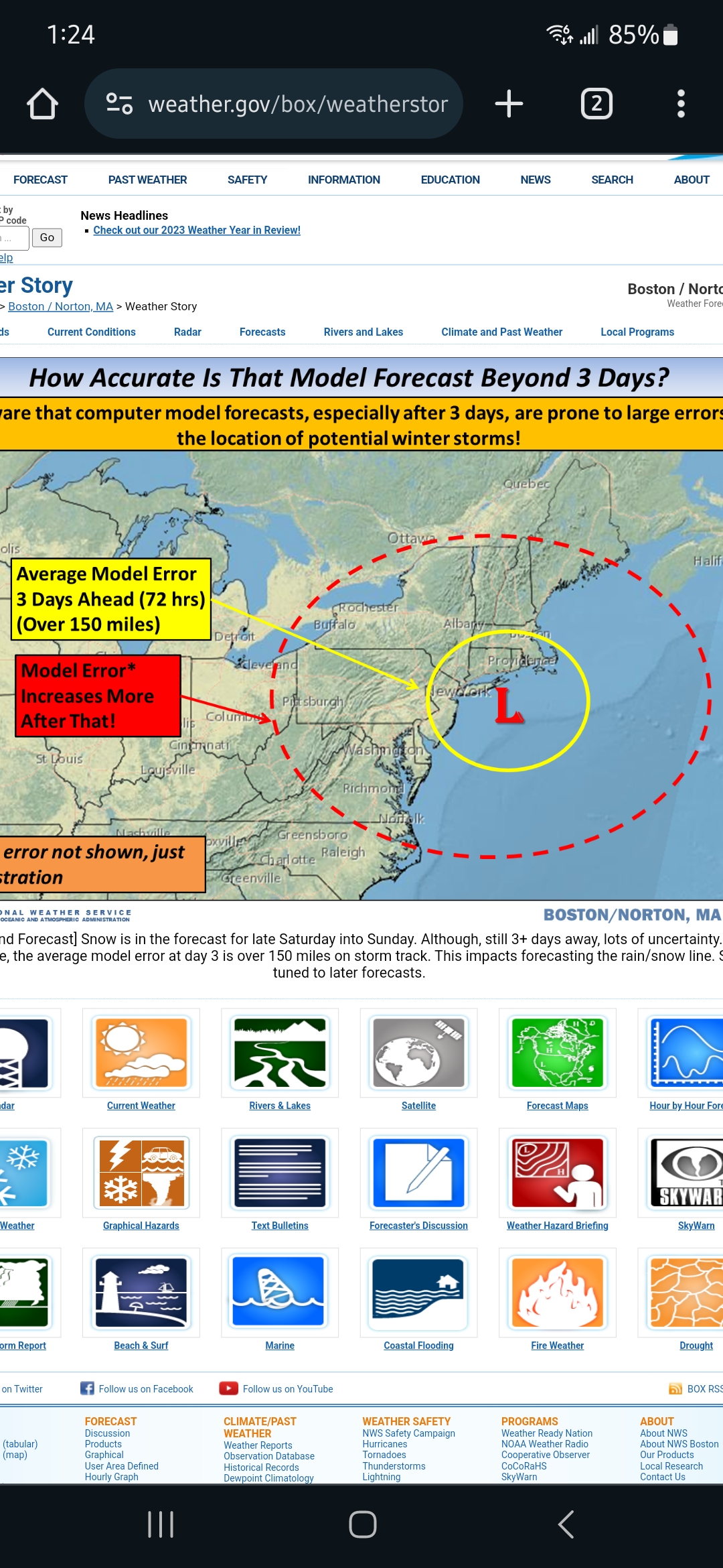
I think this a good visual reminder about models this far out.
-
Me in a week when I hear sleet pinging off the windows...
.jpeg.f71219de93aa666cecb44037927bf75c.jpeg)
-
As always we gotta let that first system roll through before we can even get excited about this one. First wave is trending drier and weaker which might allow for of a nw track with this one.
-
Winter 2023/24 Medium/Long Range Discussion
Stevo6899 replied to Chicago Storm's topic in Lakes/Ohio Valley
First storm stays SE and east coast gets a pretty solid snowstorm. Moves out quick which allows heights to rise in the middle of the country for the next system to go NW. The euro intensifies the second system but it moves ENE instead of shooting nw of chicago, which you usually see with a strenghtneing low below 980 in missouri. Perhaps blocking? -
What a wild rollercoaster it has been. I remember some winters in the past 10 where it seemed to snow almost everyday in the winter. It seems when we get into a certain pattern, it's hard to break it, even more-so when were in a warm pattern in the winter like we currently are. Luckily when we get arctic blasts <15 degrees as highs, they don't usually last longer than a week. It would be nice to have a snowy December for once as it sets the tone for the winter. It sucks having to wait this long for decent snow lol.