Kmlwx
-
Posts
13,551 -
Joined
-
Last visited
Content Type
Profiles
Blogs
Forums
American Weather
Media Demo
Store
Gallery
Everything posted by Kmlwx
-
Pretty meh here so far.
- 1,696 replies
-
- 1
-

-
- severe
- thunderstorms
- (and 5 more)
-
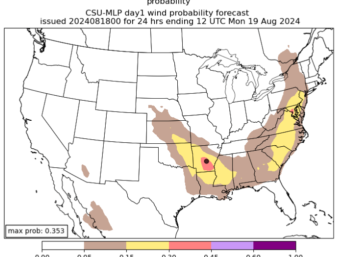
DC jackpot on the CSU MLP for today
- 1,696 replies
-
- 6
-
-
- severe
- thunderstorms
- (and 5 more)
-
About as expected. Long hurricane season remaining, though.
-
I'll be very curious to see the UNL Drought Monitor update next Thursday.
-
Odds seem (as always) low at this point. But if that trough gets cutoff or goes sufficiently negative i don't see why that -couldn't- happen. Seems lots of options are on the table (as always). But that is the big wildcard scenario IMO for east coast impacts.
-
Late reply, sorry! GREarth (requires subscription)
-
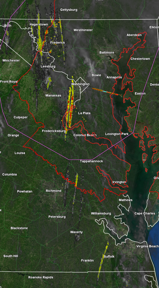
Wow this training line looks like it means business. Multiple possible spinny areas embedded in it. Tropical system life!
-
The activity in Charles County, MD has beefed up recently.
-
That stuff east and northeast of Richmond bears watching as it heads up into our area.
-
1hr rotation tracks

-
Just saw they are discontinuing the streamgage near me...seems like a funding issue. Bummed out - https://waterdata.usgs.gov/monitoring-location/01650500/#parameterCode=00065&period=P7D&showMedian=false @Eskimo Joe - Is county funding not something that can help here? Probably a discussion for DM or banter. Seems a few other gauges in the area are "endangered" as well.
-
Decent looking couplet approaching Rockville.
-
Tornado Watch reissued until 2pm.
-
https://caps.ou.edu/reu/reu21/finalpapers/Sloan_FinalPaper.pdf
-
Doesn't LWX have some additional responsibility for the Chesapeake Bay? I might be wrong.
-
If that track verifies - the conditional TOR threat would certainly be present.
-
Lord GooFus
-
Disgusting out there with a 78 dewpoint....heat index over 100 here already.
-
It's far enough west that it bring a tornado threat into play.
-
If only we were in S PA. CSU MLP and SPC seem decently enthusiastic about their odds for severe t'storms today.
- 1,696 replies
-
- 3
-
-
- severe
- thunderstorms
- (and 5 more)
-
Lately it seems like the first REALLY refreshing air masses don't show up until well into October lol
-
Latest HRRR sucks horribly.
-
NAM nest rolling in now is weaker and HRRR seems less enthusiastic as well.
-
The usually stingy HRRR is actually semi-decent - maybe not for severe but storms across a decent chunk of the area. Of course there will be deadzones and jackpots. CAMs vary in coverage and intensity.
- 1,696 replies
-
- 1
-

-
- severe
- thunderstorms
- (and 5 more)