

Kmlwx
-
Posts
13,431 -
Joined
-
Last visited
Content Type
Profiles
Blogs
Forums
American Weather
Media Demo
Store
Gallery
Everything posted by Kmlwx
-

2021 Mid-Atlantic Severe Weather - General Discussion
Kmlwx replied to Kmlwx's topic in Mid Atlantic
CIPS would support something around that time. The 120hr panel is lit up decently. -
2021 Mid-Atlantic Severe Weather - General Discussion
Kmlwx replied to Kmlwx's topic in Mid Atlantic
This was the 15z surface map. Not today, folks. I'll be back watching CIPS.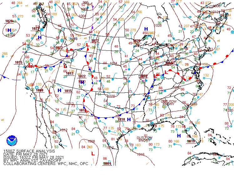
-
2021 Mid-Atlantic Severe Weather - General Discussion
Kmlwx replied to Kmlwx's topic in Mid Atlantic
Honestly - based on wind obs - the front is likely all the way down in central or southern VA still. Louisa, VA area still showing NE winds. -
2021 Mid-Atlantic Severe Weather - General Discussion
Kmlwx replied to Kmlwx's topic in Mid Atlantic
After some sun earlier this morning - it's been pretty overcast since. Was able to get the lawn mowed - it doesn't "feel" like severe today. -
2021 Mid-Atlantic Severe Weather - General Discussion
Kmlwx replied to Kmlwx's topic in Mid Atlantic
Wind direction is usually a good indicator. Winds look like they are out of the ENE in most of Maryland. Would seem to indicate the warm front isn't there yet. I've had some sun already in the Colesville, MD area. We've seem some cases in the past where even areas just north of the front can get action if something anchors along the front. Today is far from a guarantee on anything for anybody. But I'd definitely want to be south of DC as everyone has been mentioning. Southern MD and the Spotsylvania area might be a good place to be for action. -
2021 Mid-Atlantic Severe Weather - General Discussion
Kmlwx replied to Kmlwx's topic in Mid Atlantic
Any time we are looking at a warm front - it's always a game of inches. If the warm front blasts through we get warm sectored - but lose the nice wind profiles...but if it stays south we stay socked in. -
2021 Mid-Atlantic Severe Weather - General Discussion
Kmlwx replied to Kmlwx's topic in Mid Atlantic
That new hi-res FV3 model on TT looks good for tomorrow - too bad it's almost alone - along with the ARW. -
2021 Mid-Atlantic Severe Weather - General Discussion
Kmlwx replied to Kmlwx's topic in Mid Atlantic
Slight risk for tomorrow. -
2021 Mid-Atlantic Severe Weather - General Discussion
Kmlwx replied to Kmlwx's topic in Mid Atlantic
Lots of PEPCO outages showing preliminarily in the area off of Old Georgetown Rd in Bethesda. -
2021 Mid-Atlantic Severe Weather - General Discussion
Kmlwx replied to Kmlwx's topic in Mid Atlantic
Better storm than the brief thing earlier. Lots of lightning/thunder, and VERY hefty rain. -
2021 Mid-Atlantic Severe Weather - General Discussion
Kmlwx replied to Kmlwx's topic in Mid Atlantic
Pretty nice signature - will miss me to the south. But the beltway area should get smacked around a bit. -
2021 Mid-Atlantic Severe Weather - General Discussion
Kmlwx replied to Kmlwx's topic in Mid Atlantic
I got a brief rumble of thunder and a 5 minute downpour earlier. But certainly nothing noteworthy. Nice to have the rain, though. That SVR cell looks like it will miss me to the north -
2021 Mid-Atlantic Severe Weather - General Discussion
Kmlwx replied to Kmlwx's topic in Mid Atlantic
I''ll take my gusty showers and enjoy them I suppose. -
2021 Mid-Atlantic Severe Weather - General Discussion
Kmlwx replied to Kmlwx's topic in Mid Atlantic
Trajectory would seem to argue that my only hope is the cell between MIddleburg and Leesburg (if it can ramp up. -
2021 Mid-Atlantic Severe Weather - General Discussion
Kmlwx replied to Kmlwx's topic in Mid Atlantic
Other than the storm to the west of Manassas - things look pretty meh locally. -
2021 Mid-Atlantic Severe Weather - General Discussion
Kmlwx replied to Kmlwx's topic in Mid Atlantic
Radar actually looks decent. Lots of cells - if they can congeal and gain some intensity it could be a fun afternoon. They could just as easily form a DC area split, though. -
2021 Mid-Atlantic Severe Weather - General Discussion
Kmlwx replied to Kmlwx's topic in Mid Atlantic
Love that little appendage in the watch county outline in the counties bordering Garrett Co, MD. -
2021 Mid-Atlantic Severe Weather - General Discussion
Kmlwx replied to Kmlwx's topic in Mid Atlantic
Sun is out here in Colesville, MD -
2021 Mid-Atlantic Severe Weather - General Discussion
Kmlwx replied to Kmlwx's topic in Mid Atlantic
SPC seems to agree with the 2% - but shear is pretty weak sauce. Could be fun to see some quarter sized hail. -
2021 Mid-Atlantic Severe Weather - General Discussion
Kmlwx replied to Kmlwx's topic in Mid Atlantic
It's overall continued to be a very, very quiet May for the region. Question becomes whether we will get slapped around to break the quiet streak - or if it'll continue or just end with a whimper and a few storms. -
The sound has gotten louder and louder the last few days. I drove through Laurel this morning and could hear it even while in the car with all of the windows up.
-
2021 Mid-Atlantic Severe Weather - General Discussion
Kmlwx replied to Kmlwx's topic in Mid Atlantic
The GFS beyond 300 hours kind of has the ring of fire look to it. Big ridge in the center of the country/midwest and us on the eastern edge. -
Today was the day. In the last hour or two I'm seeing increases in the hundreds it seems under the trees in the front yard. Can definitely hear a few singing already - but mostly it's tons of them coming up out of the lawn and crawling towards the trees. Here we gooooo
-
*Think* I can hear one or two. And found a small-ish shell on a tree. But definitely not major emergence here today. But between that and I did see one flying earlier. Probably going to go big here tomorrow with the warmer night and closer to 90 tomorrow.
-
2021 Mid-Atlantic Severe Weather - General Discussion
Kmlwx replied to Kmlwx's topic in Mid Atlantic
It could just as easily be into June that we are waiting to see anything decent.

