ORH_wxman
-
Posts
93,092 -
Joined
-
Last visited
Content Type
Profiles
Blogs
Forums
American Weather
Media Demo
Store
Gallery
Everything posted by ORH_wxman
-
CF is sitting almost over Shrewsbury…24F on winter hill right now but about 31 Shrewsbury/Northborough line
-
Absolutely scalping here. Everytime it seems it wants to go to more straight ZR (or RA since it’s now 32F), it starts going crazy with the pellets again. Should finally go to RA pretty soon at some point.
-
Snowing moderately still. Looks like sleet is washing out just southwest for the time being but it’s getting close.
-
Sleet line really tilted. HFD to GON right now.
-
It’s honestly amazing. Like 3 fights broke out in the first minute of the game. All star game should be cancelled every year for this.
-
It’s been their year up there. The seasonably cold dry period in January was upslope heaven up there and these snyoptic events recently are very good for NNE. At least it has been pretty decent down here from a wintry appeal aspect since 1/11. Would be nice to get a larger storm though.
-
23F and mod to heavy snow. About 2” down eyeballing. Maybe a touch more.
-
Pounding some good dendrites in this band. If we can keep this up, we might pull 6”…but I’m expecting it to go back to baking powder at some point.
-
23F and moderate snow.
-
Have almost an inch. Wasn’t expecting that until 8-9pm. Nice bonus. We ripped pretty good for an hour. Little mini-lull now until heavier bands move back in.
-
Nice midlevel look for SE MA
-
The dryslot should fill in as it moves east. Parts of CT might deal with it for a time but all the guidance has precip filling in pretty quickly.
-
Yes I’m hedging heavily toward NAM. We’ll know around 10pm if it’s more correct or not based on the sleet line in CT. It usually is better to hedge faster flip in these. Only thing that is kind of different here is it has the warmest layer in the 825-850 region overnight. That is a good tick lower than we typically see…usually I’m looking at 750-800 layer…occasionally even 725.
-
It’s close. HRRR and rap have you snowing but 3k NAM has the pingers arriving right around midnight there.
-
Much better to go old school and look for the timing of the flip and then print out total model QPF at that hour. Hrrr flips the pike between 10-11z and this is modeled QPF through 11z…I think it’s a little weenie-ish though…gotta a feeling it might be closer to the NAM 08z timeframe, so I’d shave a couple of inches off the hrrr here…not buying 6-8”

-
Yes there are definitely defense mechanisms in both directions. Very well known for anyone who has been on these forums for years. This threat is still definitely there but it’s got work to do. Silly to declare it dead or locked at this range.
-
The flip side of it is I don’t feel sorry for anyone who got emotionally invested in a 156 hour model output. No matter how “good” it looked.
-
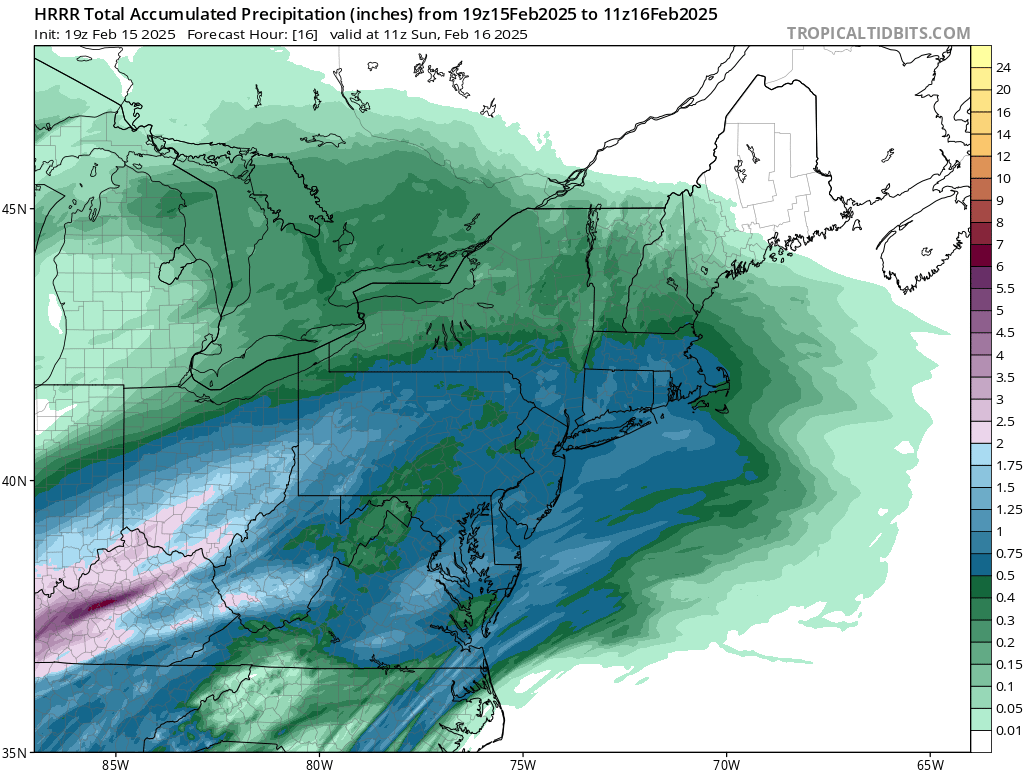
Hrrr has 2” of QPF here. Nearly 1” falls as frozen/freezing but that leaves another 1” of QPF as 33-34F rain. Gonna be a lot of liquid in the pack. hrrr might be overdone a bit though. Esp in the slot.
-
Yeah it was a solid 8-10” when the forecast was 3-5”. I remember Ekster saying as soon as he woke up at 6am and heard muffled car sounds outside and no pinging and a white fog out the window, he went “ohhhh shit, the 3-5” is busting”
-
Yep…the original “Kevin dumbfounded” jokes were back when he was complaining that it was heavy snow on the Cape while he was pelting in Tolland during the 12/16/07 event
-
Trying to dump 7-8” here. Yeah, not buying it. But I’m feeling better about 4-5” before the flip.
-
What are you looking at?
-
That thing north of maine is a much bigger problem than the four corners shortwave
-
It’s a big hit for you too. It’s just the 17z hrrr doesn’t go out far enough to catch all the snow north of the pike.
-
18z rap is big hit again around the pike.