

ORH_wxman
-
Posts
93,092 -
Joined
-
Last visited
Content Type
Profiles
Blogs
Forums
American Weather
Media Demo
Store
Gallery
Everything posted by ORH_wxman
-
Outside of something rogue very late, Mar 5-12 stretch is prob our last best shot at something decent.
-
Maybe up by powderfreak it's worth tracking. GFS was on crack....18z Euro run yesterday was rogue.
-
Yes but i think these are weighted against climo? So if it's higher than the typical baseline, it would screw things up potentially.
-
Def gonna happen just so early April is ruined.
-
Love the 2nd to last picture. Nice view of Pleasant Mountain there? I recognize it from when we go up to the same Lake house every summer on Moose Pond right in the shadow of it.
-
2000 was 80+ I remember. Also I think mid-March 1990 had a sneaky 80s at ORH….very hard to do there.
-
I remember everyone at work and out and about saying that in 2018 when we had that February 70F torch and then we had 40”+ in March. I’m sure this year will be 45F and rain.
-
Pretty big strat warm signal on ensembles for early March. That will manifest as a perfect pattern at the end of March and April. Welcome to Tip’s favorite season.
-
You’ll be rewarded with 50% of the days being Atlantic ass mist once you celebrate the end of snow threats.
-
Yes. Also doesn’t mean that will continue. Or…maybe we get an ugly looking chart mid-month and it produces a storm which sometimes happens in March with shorter wavelengths.
-
Everyone always tries to rush the end of winter every late February and March. It’s like we all of the sudden live in Virginia.
-
The first half of March looks pretty interesting. Maybe we can finally pop a big one, but probably not.
-
No the flash freeze event was a few days earlier on 3/8/05. That’s the one that had massive winds too. The 3/12/05 event was basically an advisory event that busted positively into a big warning event. It was essentially a really juiced inverted trough with the low going offshore but the upper support was hanging back and we just pounded snow almost all day. I think we ended up with 11” or so when 3-6 was the forecast the night before.
-
3/12/05 was underrated over the interior too. We had almost a foot of snow in that. Huge bust as only like 3-6” was forecasted.
-
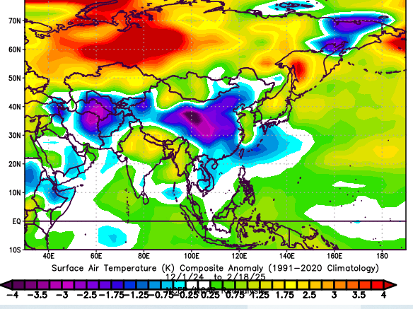
Yeah but mid-latitudes have plenty of cold which makes sense given the pattern…lots of big blocking in the arctic. So your arctic domains are a torch but not the mid-latitudes.
-
The southeast def had a pretty cold winter and almost nobody called for it given it was a La Nina....usually SE ridge and mild weather dominates there but not this time.
-
Just for reference, here is 2014-15
-
We also drastically underperformed the anomalies at 850...
-
December was quite cold from China to ME too. It was actually the coldest stretch on the globe outside of a frigid Greenland that month.
-
China over to the eastern part of the Middle East was pretty cold this winter as well.
-
Yeah I'm guessing people got so acclimated to the last two winters that they are starting to think that +5 against 1991-2020 climo is the "New normal"....this was basically an average winter for temps...maybe slightly BN. We will see winters significantly colder than this one.
-
Oh yeah, even a dud winter will seem like a blockbuster if you’re coming from down south. This winter at least has been cold enough to keep the snow around even if we haven’t gotten a lot of it. I think I’m already working on about 40-45 days of snow cover which is honestly kind of amazing given I’ve barely breached 30” on the season. Might crack 60 days this year if we can add something in the next 10-14 days.
-
Wasn’t that long ago that 60” was a crap season IMBY. How the mighty have fallen.
-
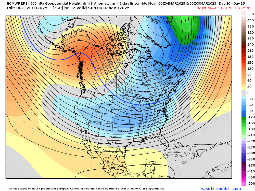
Yep just posted above how good it looks out west for once. But we need Quebec to cooperate…the irony is it’s been cooperative a lot of times this winter when out west was not…but now when we really need the PV in Quebec to play ball, it’s wavering on us. The trend has been good the last day or two. If we see another move SE on that PV tonight and tomorrow, then it probably becomes a serious threat…it will be getting inside of D6 by tomorrow too.
-
There’s a lot of synoptically favorable pieces on this setup out west and into the center of the country…the one key aspect that needs locking down is what happens north of us. Right now, that PV entity is a little too far north or west…move it either south or east (or some combo), and then we’re really talking a significant snow threat…it’s been trending southeast a bit so if it does it a little more, we may have something to track. But I wouldn’t get hopes up yet. If it doesn’t, this remains uninteresting.


