

ORH_wxman
-
Posts
93,095 -
Joined
-
Last visited
Content Type
Profiles
Blogs
Forums
American Weather
Media Demo
Store
Gallery
Everything posted by ORH_wxman
-
November 2025 general discussions and probable topic derailings ...
ORH_wxman replied to Typhoon Tip's topic in New England
Too much absolutism here. We don’t even know how things will look beyond about 12/14….weeklies actually load a bit of a western ridge leading into Xmas week. Don’t know if I buy it, but there’s plenty of ways to snow if we can keep frigid air in Canada close by which looks to be the case at least. Our glory days of December had cutters too in the 2000s…they are likely to happen. -
November 2025 general discussions and probable topic derailings ...
ORH_wxman replied to Typhoon Tip's topic in New England
Kind of wish the -NAO didn’t disappear on us. Guidance had been quite bullish on it for December but now it’s basically gone. Don’t need a Davis strait block but a bit of -NAO would help pin that cold a little further south. As long as we keep good cross polar flow though and that PV anomaly in SE Canada stays strong, we’ll have chances, but there’s def gonna be some risk we mix in a cutter. -
November 2025 general discussions and probable topic derailings ...
ORH_wxman replied to Typhoon Tip's topic in New England
Yeah let’s get the Mohawk back in the avatar and pretend it’s the late 2000s Decembers when SWFEs were a dime a dozen. -
November 2025 general discussions and probable topic derailings ...
ORH_wxman replied to Typhoon Tip's topic in New England
WPO/EPO cold press is really evident after about the 2nd of December. We’ll see if we can cash that in for some snow events but I’m fairly optimistic right now. I’m not full-on weenie mode like you’d see with a PNA ridge going up to Yukon Territory, but given the Niña background state and strong -PDO, this is a pretty good look for us in early December. Doesn’t mean a whole lot yet, but also I noticed the EPS mean is creeping up little by little for snowfall. It has about 3-6” across SNE now in that Dec 3-9 period. So it def has some members in there producing decent snow. I do like seeing the consistent low height max in Quebec/Labrador on that 5-day mean H5 anomaly between Dec 3-8. It’s a very good spot to hold in those arctic highs during a SWFE. We haven’t seen much of that since the glory days.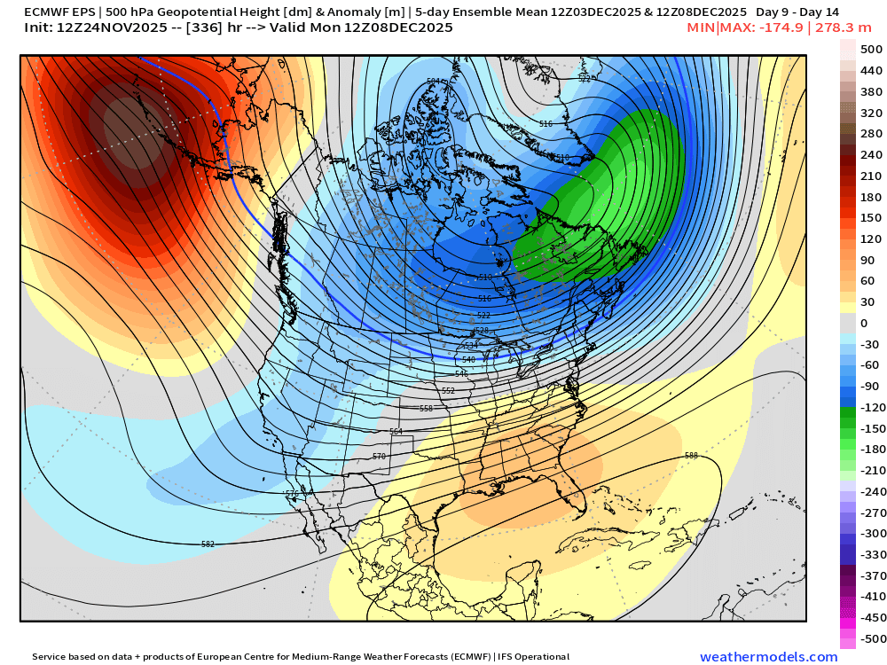
-
Wow, this is very impressive. Thanks for putting this together. I only had enough ambitions to do some seasonal maps and a few bigger storm maps. Doing most major storms for this long of a period is not only very impressive, but it excellent for preserving good records of storms. As the memory of those storms fade (and sadly the people who remember those pass on), we only have whatever was archived to look back on.
-
November 2025 general discussions and probable topic derailings ...
ORH_wxman replied to Typhoon Tip's topic in New England
12z GFS def had several chances in the long range. That period after about 12/2 gets pretty interesting. There’s still risk that we end up on the warm side but I like seeing a lot of reinforcing PV shots into SE Canada…that’s ultimately what will give us the confluence and antecedent airmass we need. So the more reinforcing shots that we see on guidance, the better our chances. -
November 2025 general discussions and probable topic derailings ...
ORH_wxman replied to Typhoon Tip's topic in New England
We’re gonna end up like 2007 except shifted 80-100 miles north. We’ll be like NYC that December. -
November 2025 general discussions and probable topic derailings ...
ORH_wxman replied to Typhoon Tip's topic in New England
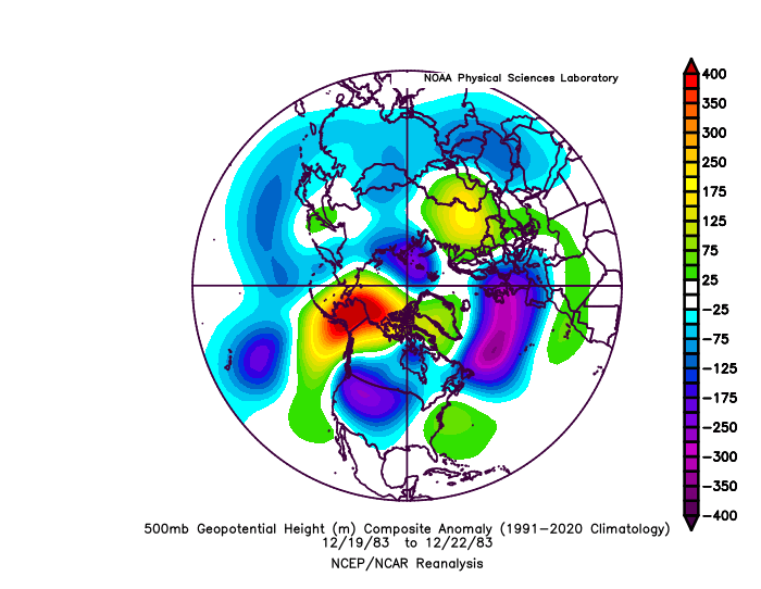
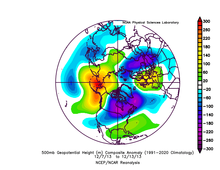
2008 also had a similar SE ridge (this is the setup for the prolific back to back snow events that month pre-Xmas)…the key to keeping it cold in New England is the big SE Canada vortex. If you don’t have that, you can’t hold that high/confluence long enough. Here’s prior to the 12/22/83 SWFE as well. Big massive cold dump into the plains and Rockies with decent SE ridge but we had some good antecedent cold held in by that confluence in SE Canada..little mini NAO on the ‘83 look but it’s the same idea/concept…anything to hold confluence over SE Canada. Here’s the back to back SFWE setup in December 2013 as well…look at that SE Canada region…huge -WPO/-EPO fighting that SE ridge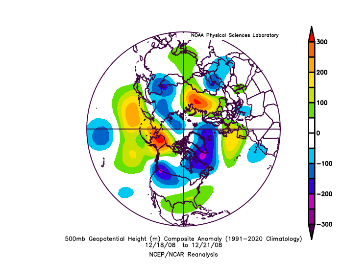
-
November 2025 general discussions and probable topic derailings ...
ORH_wxman replied to Typhoon Tip's topic in New England
It’s def not a Kocin cookbook pattern at all. But sometimes our best stretches are when we have to play with fire. Ala those 2007 and 2008 type stretches with lots of battleground between SE ridge and confluence to the north. But if we’re gonna deal with classic La Niña deep -PDO and a -PNA pattern, this is one of the better ones to try and make it work…you have excellent cross polar flow showing up almost the entire run so at least we will have true arctic cold not far away. -
November 2025 general discussions and probable topic derailings ...
ORH_wxman replied to Typhoon Tip's topic in New England
Here’s the mid December 2007 stretch that was quite kind to the region. Esp N of pike but even that 12/13 event got your area good. 12/16 hammered pike northward. You can see that big vortex in SE Canada.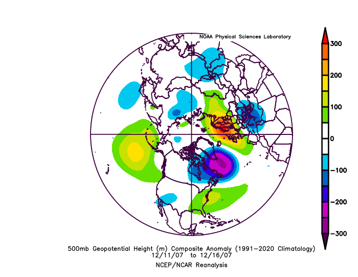
-
November 2025 general discussions and probable topic derailings ...
ORH_wxman replied to Typhoon Tip's topic in New England
Not sure we’d need any NAO ridging with that look. That’s pretty cold. That SE Canada and Atlantic look is very reminiscent of early to mid December 2007…the WPO is more negative than ‘07 though…that’s pure cross polar there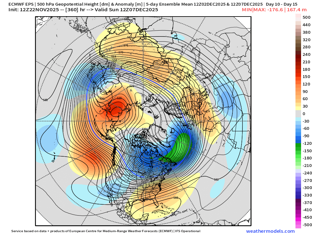
-
November 2025 general discussions and probable topic derailings ...
ORH_wxman replied to Typhoon Tip's topic in New England
Yeah def -PNA early on. There are some similarities to ‘07. Not exact match. -
November 2025 general discussions and probable topic derailings ...
ORH_wxman replied to Typhoon Tip's topic in New England
Yeah the euro was trying to get us too on that 12/3-4 system. We’ll see. Volatile solutions in this setup so I’d expect a lot of swings in guidance. We’re still in clown range anyway but these are the types of patterns you can oscillate between 60F cutters and cold SWFEs until you get inside 6 or 7 days. (In the old days it might do that until 4-5 days out) -
November 2025 general discussions and probable topic derailings ...
ORH_wxman replied to Typhoon Tip's topic in New England
We’ll have a torch spike on the cutter the first few days of December (whenever that thing actually cuts…still wiggle room on guidance)….but we may drop the hammer after that. Canada is frigid and we start getting that cold -WPO cross-polar press. It’s hard to stay warm with that look. I’d be surprised if we didn’t have multiple SWFE threats between 12/5-12/15. Might even be able to sneak something a touch sooner. Esp NNE. -
November 2025 general discussions and probable topic derailings ...
ORH_wxman replied to Typhoon Tip's topic in New England
It's funny how the objective D11 analogs right now all point to years with SWFEs in early December.....top analog is 11/29/91 (big SWFE on 12/3/91).....2007 shows up twice on the list....so do 1972, 1978 and 1983 (all 3 had early Dec SWFEs...'78 was more of a front ender cutter, but still) -
November 2025 general discussions and probable topic derailings ...
ORH_wxman replied to Typhoon Tip's topic in New England
Gonna be several shots at a SWFE i think in the first 10 days of Dec....pattern has that look. -
November 2025 general discussions and probable topic derailings ...
ORH_wxman replied to Typhoon Tip's topic in New England
Wonder when the GFS and foreign guidance is going to converge on Tday. GFS still like a full day slower with that trough. Foreign models all have the front offshore by Tday morning. -
November 2025 general discussions and probable topic derailings ...
ORH_wxman replied to Typhoon Tip's topic in New England
Holiday period is way out there a month-plus from now, but none of the guidance has that period as a torch right now. If anything, it shows up as pretty damned cold on weeklies. -
November 2025 general discussions and probable topic derailings ...
ORH_wxman replied to Typhoon Tip's topic in New England
BOS will prob get colder post-Tday on that weekend. Into the 20s I’d think. -
November 2025 general discussions and probable topic derailings ...
ORH_wxman replied to Typhoon Tip's topic in New England
Ironically it seems the worst offending decade was the 1990s…no October or early Nov snows and plenty of late ones. You wouldn’t think so in an otherwise fairly snowy decade. -
November 2025 general discussions and probable topic derailings ...
ORH_wxman replied to Typhoon Tip's topic in New England
Remember the glory days of 2002-2010….so many epic December events on the forums…Xmas 2002, Dec 5-7, 2003, 12/9/05 , 12/13/07, 12/11/08 (ice storm), etc -
November 2025 general discussions and probable topic derailings ...
ORH_wxman replied to Typhoon Tip's topic in New England
Yeah every month had major events....'02-'03 and '95-'96 both seasons (not October in 1995, lol...but still November to April) 2014-15 had a dud December here which kind of ruined the wire to wire vibe....too bad because we slammed over the interior on T-day eve that year with a nice warning event. '17-'18 was very solid Dec-Mar, but not much in April or November that season. -
November 2025 general discussions and probable topic derailings ...
ORH_wxman replied to Typhoon Tip's topic in New England
Thanksgiving Eve into T-day morning has been trending colder too. Not expecting much winter precip here but interior CNE northward might grab something. If we somehow tick it another nudge colder, then maybe it gets interesting down into interior pike region. OF course, maybe it's not much at all like the Euro had.... -
November 2025 general discussions and probable topic derailings ...
ORH_wxman replied to Typhoon Tip's topic in New England
It was pretty close to wire to wire over interior SNE north of 84. They cashed in during both the Xmas ‘02 event and the early Jan ‘03 event with basically very little melting and that lasted until the big February snow events which added more pack to an already good one. We did get an ugly cutter in very late February that year. There was a cutter about a week before Xmas too that kind of put a gap between the Thanksgiving week/early December snows and the Xmas event. But again, pretty close to wire to wire…esp for SNE standards. -
November 2025 general discussions and probable topic derailings ...
ORH_wxman replied to Typhoon Tip's topic in New England
That whole 11/29-12/1 period is semi-interesting. There’s going to be troughing most likely entering the Midwest so if we have some local confluence/cold press ahead of it, then we might be able to sneak an event in there. OP euro shows a colder look on that today. As usual, best chance this early is going to be interior and prob some latitude as well, but something to watch.


