ORH_wxman
-
Posts
93,099 -
Joined
-
Last visited
Content Type
Profiles
Blogs
Forums
American Weather
Media Demo
Store
Gallery
Everything posted by ORH_wxman
-
First Winter Storm to kickoff 2025-26 Winter season
ORH_wxman replied to Baroclinic Zone's topic in New England
06z euro kind of looks like 06z GFS. They are pretty close now. -
First Winter Storm to kickoff 2025-26 Winter season
ORH_wxman replied to Baroclinic Zone's topic in New England
3k is pretty similar but not as crazy prolific. Still a decent area of 12”+ -
First Winter Storm to kickoff 2025-26 Winter season
ORH_wxman replied to Baroclinic Zone's topic in New England
Gives ORH 2 feet, lol. What a model. -
First Winter Storm to kickoff 2025-26 Winter season
ORH_wxman replied to Baroclinic Zone's topic in New England
We’re gonna get NAM’d this run. -
First Winter Storm to kickoff 2025-26 Winter season
ORH_wxman replied to Baroclinic Zone's topic in New England
GFS looks just a smidge colder near here than 18z but at this point it’s noise unless it does it again another couple of cycles. -
First Winter Storm to kickoff 2025-26 Winter season
ORH_wxman replied to Baroclinic Zone's topic in New England
This area is pretty often on the correct side of the “495 gradient” despite being a little inside 495. But so many times I’ve seen huge gradients like 2 towns east. But you do get these events sometimes where it’s really more like ORH is the line…the lower part of the city even might be on the warm side of the gradient. This happened during the ice storm in 2008. Also during the March 2023 Firehose event. Lower elevations literally had 5” of slop and it was like 15” on winter hill and then 2 feet another 5 miles NW. granted, that was the most extreme I’ve seen. -
First Winter Storm to kickoff 2025-26 Winter season
ORH_wxman replied to Baroclinic Zone's topic in New England
I’m hedging on the lower end here at the moment. I’m not convinced of some of these rates but we’ll see. If we can get a temporary bombing low scenario which isn’t impossible for a few hours, then we might be able to rip if we stay on the cold side. Id feel a lot better on winter hill, lol -
First Winter Storm to kickoff 2025-26 Winter season
ORH_wxman replied to Baroclinic Zone's topic in New England
These early runs have a been a little flaccid on dynamics. But some of these mesos were also pretty bonkers to begin with. The massive 1-1.5 QPf getting well inland never looked that realistic. -
First Winter Storm to kickoff 2025-26 Winter season
ORH_wxman replied to Baroclinic Zone's topic in New England
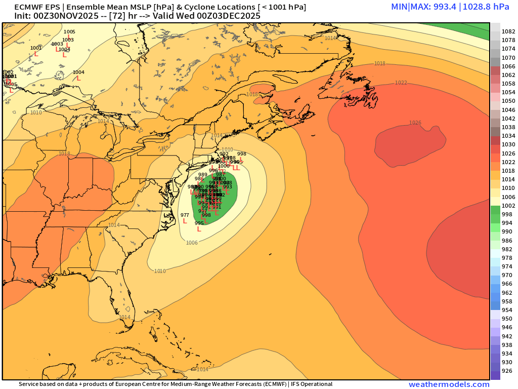
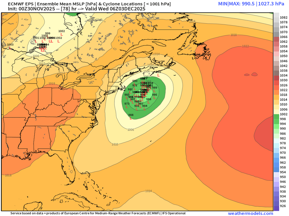
Yeah we were tossing those NAM solutions with lots of confidence at 72-84 hours. It was well beyond what even the most amped globals had. I think the most surprising aspect is how little the euro has moved. If anything it moved south until finally ticking back north a little at 18z. I kind of expect a pretty even compromise between it and GFS now which will end up as the common 70/30 from a couple days ago. -
First Winter Storm to kickoff 2025-26 Winter season
ORH_wxman replied to Baroclinic Zone's topic in New England
The ultimate inhibitor is going to be initialization. That’s always the main issue. That’s something that even AI can’t solve easily. -
First Winter Storm to kickoff 2025-26 Winter season
ORH_wxman replied to Baroclinic Zone's topic in New England
I’m assuming AI will eventually learn from its errors. But it’s prob gonna be a bumpy road. -
First Winter Storm to kickoff 2025-26 Winter season
ORH_wxman replied to Baroclinic Zone's topic in New England
Nasty forecast here…if gradient is closer to 128, then we rip here. If it’s more like just outside of 495, we’re in trouble. I think ORH to Ray’s area is in good shape. -
First Winter Storm to kickoff 2025-26 Winter season
ORH_wxman replied to Baroclinic Zone's topic in New England
Sorry I meant storm vista. The wx bell isn’t that different than the weathermodels. Some differences on the margins but SV was like a Taunton to Carver jackpot, lol -
First Winter Storm to kickoff 2025-26 Winter season
ORH_wxman replied to Baroclinic Zone's topic in New England
I also cannot believe the model differences at less than 48 hours out. -
First Winter Storm to kickoff 2025-26 Winter season
ORH_wxman replied to Baroclinic Zone's topic in New England
What’s up with the wx bell clown maps. Doesn’t look like the weathermodels one.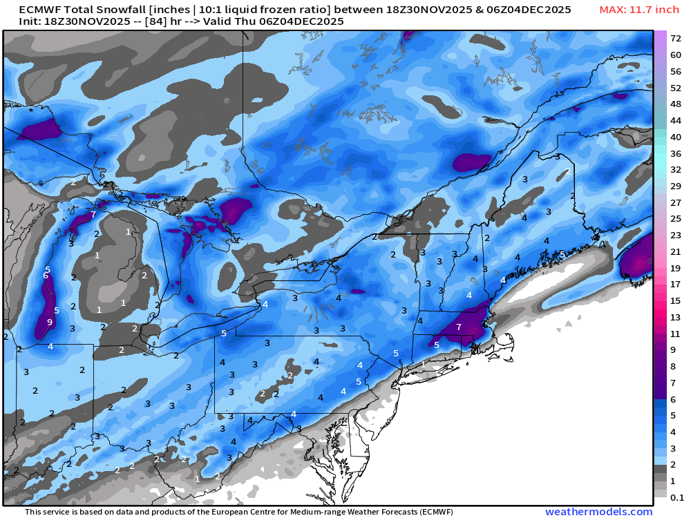
-
First Winter Storm to kickoff 2025-26 Winter season
ORH_wxman replied to Baroclinic Zone's topic in New England
GFS came in a little colder too. Maybe we’ll get a GFS/Euro convergence today. -
First Winter Storm to kickoff 2025-26 Winter season
ORH_wxman replied to Baroclinic Zone's topic in New England
They look a bit juicier than the OP in terms of amplification but not by much. But that’s prob a good sign we’re gonna see model convergence. Betting OP is still a bit too flat
-
First Winter Storm to kickoff 2025-26 Winter season
ORH_wxman replied to Baroclinic Zone's topic in New England
Euro AI itself is a massive hit for us in the moderate interior. But trusting any OP right now is asking for trouble. I think we’d take a model blend right now and run. -
First Winter Storm to kickoff 2025-26 Winter season
ORH_wxman replied to Baroclinic Zone's topic in New England
Yeah I thought for a minute it was gonna try and NAM further south for the ending but it didn’t quite have enough juice aloft. NAM is still in its own world with that h5 look deepening so fast. -
Yep but it was after the 12z rogue GFS run. Nobody believed the GFS and then the 18z runs all started trending toward it.
-
First Winter Storm to kickoff 2025-26 Winter season
ORH_wxman replied to Baroclinic Zone's topic in New England
Crazy gradients around 495 on both models. Rgem looked a little cooler by a smidge. Not that we really care what these models say unless the euro and GFS agree with them at this time range. -
First Winter Storm to kickoff 2025-26 Winter season
ORH_wxman replied to Baroclinic Zone's topic in New England
I think Boxing Day 2010 was basically the only time the GFS scored a NW coup in the 2005-2020 era. I do remember it scored a NW coup in back when it was the AVN in the New Years weekend 2000 storm. But that was back when the 12z Euro came out at 8pm on weather.unisys -
First Winter Storm to kickoff 2025-26 Winter season
ORH_wxman replied to Baroclinic Zone's topic in New England
I think you all are overestimating how good the forecasts/model guidance was 10 or 15 years ago. We used to have SWFEs in the late 2000s and early 2010s hammering DC like 4 days out and then mixing got into S NH by verification. Back in the days when Ekster was trolling Nikolai 4 days out on how the GFS DC jackpot was a great sign for New England. Once we got inside 84 hours, we started getting deadly at times (and all of us knew many of the model biases back then as they were more distinct)….but even then, we had plenty of crazy moves inside of 3 days. -
First Winter Storm to kickoff 2025-26 Winter season
ORH_wxman replied to Baroclinic Zone's topic in New England
A 2 to 1 blend in favor of Euro would actually be one of the few ways we get widespread 4-8” amounts across a lot of SNE into CNE. Maybe we’ll actually catch a knife’s edge in our favor this time. Would be nice juju to start the season after the last several years. -
First Winter Storm to kickoff 2025-26 Winter season
ORH_wxman replied to Baroclinic Zone's topic in New England
Euro would be nice for interior SE MA. Wonder if Brett can whine his way to a warning event.