ORH_wxman
-
Posts
93,095 -
Joined
-
Last visited
Content Type
Profiles
Blogs
Forums
American Weather
Media Demo
Store
Gallery
Everything posted by ORH_wxman
-
First Winter Storm to kickoff 2025-26 Winter season
ORH_wxman replied to Baroclinic Zone's topic in New England
That euro run is crazy. Still think compromise between euro and GFS is the most likely. -
First Winter Storm to kickoff 2025-26 Winter season
ORH_wxman replied to Baroclinic Zone's topic in New England
Not a bad first guess, Ray. Kind of feels like a pretty decent 128 gradient if we get a blend of Euro/GFS. I feel like both of those solutions at 18z are pretty outlier-ish -
First Winter Storm to kickoff 2025-26 Winter season
ORH_wxman replied to Baroclinic Zone's topic in New England
Gfs is so fundamentally different in how it handles the cyclogenesis. -
First Winter Storm to kickoff 2025-26 Winter season
ORH_wxman replied to Baroclinic Zone's topic in New England
One of these models is gonna be grossly off. -
First Winter Storm to kickoff 2025-26 Winter season
ORH_wxman replied to Baroclinic Zone's topic in New England
Lots of posters will be disappointed if Stowe doesn't add onto their record or near-record early season snow pack with a favorable pattern for NNE out as far as the eye can see. -
First Winter Storm to kickoff 2025-26 Winter season
ORH_wxman replied to Baroclinic Zone's topic in New England
Congrats PVD on 18z ICON -
First Winter Storm to kickoff 2025-26 Winter season
ORH_wxman replied to Baroclinic Zone's topic in New England
Looks like it's hung up in CNE at 72h....18z Mon....we really want that further south for maintaining snow down to BOS to MMK line unless the mechanics of this change a bit. One of the things that happens if you drive the height field lower over us prior to that approaching shortwave, is that it creates more confluence when that shortwave approaches. We saw a bit of this on some prior runs a few days ago when that high was kind of sticking near CAR longer before finally retreating....I made the comment that some areas could get a good front-ender even if it flipped. The trend has been away from that for several cycles now, but if it trended even a little back toward that, it would make a huge difference....particularly for people closer to the coast and further south. I don't think it's a big deal over the deeper interior. -
First Winter Storm to kickoff 2025-26 Winter season
ORH_wxman replied to Baroclinic Zone's topic in New England
SE areas will need big time rates to get more than advisory snows I'm thinking. So it's a tough needle to thread....on one hand, you want a colder/SE solution, but on the other, you still need those big rates. Best way to get it is probably push that initial cold front a little further south but also keep the shortwave fairly potent, so you get both. -
EPS and GEFS are in a model war for mid-month too now.
-
First Winter Storm to kickoff 2025-26 Winter season
ORH_wxman replied to Baroclinic Zone's topic in New England
Big cluster converging toward the BM too... -
I dunno, Bob with the mohawk avatar is good December juju.
-
That 12/10 system has a high pressure that Scooter can get behind....
-
Remember all those swears you learned when you were 2? That was your dad throwing a tantrum when he thought the January 2015 blizzard was going to miss us.
-
It actually cools a bit during the "CCB" portion of the storm
-
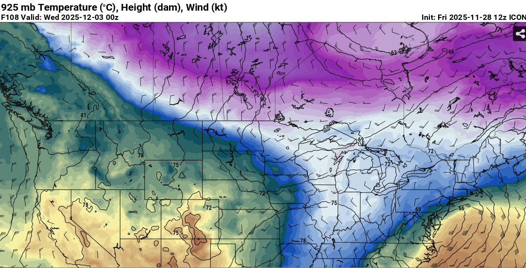
Here's 925mb at roughly the warmest....snow line prob from like over your head down to Ginxy.
-
It's a huge hit into BOS.
-
At least 12z Euro AI gets precip into interior SNE now.
-
I'm betting he's at least 75% snow in this...probably all snow. Even the zonked GFS is like right on the line for him to be mostly snow.
-
Unusable for this system....00z was almost a full whiff.
-
Might be underdone where it remains all snow....the all snow zone isn't like 33F snow unless you're in a solution where the coastal zones and SE zones are mostly snow...otherwise, its gonna be 29-32F...so accumulation should be pretty efficient even if its a little pasty.
-
Guidance blend would work pretty well for your area down to mine and Kevin's area. But you have an advantage with the latitude.
-
You're prob in a good spot...GFS only needs to be overamped by a very small margin for you to get a warning event.
-
GEM is going to be SE of 00z....looks like the Euro. D4 model war.
-
GFS is a lot more stacked than other guidance (i.e not as sloped with the pressure fields)....it's really going crazy with the main vort focusing and capturing the system....so we're seeing these tucked solutions with crazy QPF and rates....but also warmer for most of our area. I'm actually not sure which one to buy right now....I could be convinced either way. Part of me thinks GFS is a little overdone on this given the synoptics, but it's not impossible to see that solution.
-
Yep, not even close to 06z run...