

ORH_wxman
-
Posts
93,095 -
Joined
-
Last visited
Content Type
Profiles
Blogs
Forums
American Weather
Media Demo
Store
Gallery
Everything posted by ORH_wxman
-
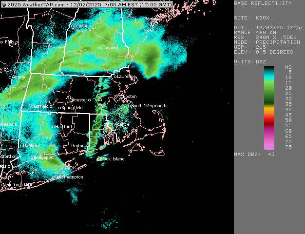
Keep checking for aggregates mixing in....CC is trying to wash out near you.
-
A little clipper redeveloper nuke? Jeez, its been years. Xmas morning 2017? Lol. We did have a little blow-up system on 2/7/21 (super bowl sunday storm that year....best band was CT over to E and SE MA)...not quite the same look, but maybe we could count it.
-
Getting a good glaze going right now...temp at 29F. Some sleet mixed in. Would be nice to latently cool that little warm layer around 900-925 enough to pound some aggregates for a bit...I noticed some of the CC on radar trying to wash out on the northern side.... but not getting hopes up. Best bet here is the Kraft ending tonight....
-
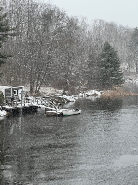
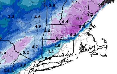
Lotta ground showing there for 2"....
-
First Winter Storm to kickoff 2025-26 Winter season
ORH_wxman replied to Baroclinic Zone's topic in New England
There's actually a pretty nice cross-hair sig in that little CCB ending for central/Eastern MA late this evening on some of the mesos....if things break right, might see a nice 3 hour burst or so.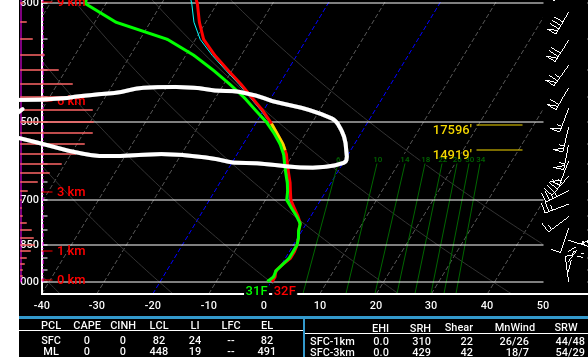
-
We had a round of sleet/snow mix....the sleet is kind of weird because it's not like we're warmed at 800-750 or anything....prob mostly shitty growth as the deeper lift is still west. Temp 28.5F
-
Some of those mesos yesterday were beyond awful at the sfc. Just complete disaster of a forecast.
-
First Winter Storm to kickoff 2025-26 Winter season
ORH_wxman replied to Baroclinic Zone's topic in New England
Yes....we should all start our own regional forecasting company once the govt goes bankrupt and they close NWS. I'm wondering how much the current sfc temp situation will cause any "drag" on the WAA at 900-950mb....they are obviously a couple to 3 thousand feet above the sfc, but we both know that a denser airmass than advertised underneath will cause some friction or drag on the advection of that 900-950 layer....it won't matter on a huge scale, but for those where 1C makes the difference, it could be a big deal. -
First Winter Storm to kickoff 2025-26 Winter season
ORH_wxman replied to Baroclinic Zone's topic in New England
Lol yeah...I got married and had kids, so it had to be close enough to work. Still not a bad location (and a bit of elevation near 400 feet) but not nearly as good as winter hill was....that place was a relative snow magnet with the 900+ elevation. -
Clipper/redeveloper sig is definitely there on EPS
-
First Winter Storm to kickoff 2025-26 Winter season
ORH_wxman replied to Baroclinic Zone's topic in New England
Nice snow map on the HRRR (I'm the red dot)
-
First Winter Storm to kickoff 2025-26 Winter season
ORH_wxman replied to Baroclinic Zone's topic in New England
3k NAM has a decent ending in E MA....prob a couple inches anyway. Esp near and N of pike. -
Wetbulbing down fast in this stuff. Down to 26.5F. Wonder if we can hold off 900-950 layer a little longer than originally advertised. HRRR and RAP have been getting stickier with that 0C line at 925 moving north with each run. I think ORH over to Ray is looking a little better than 6-12 hours ago.
-
Looks like CF is right near 128 maybe a little inside 128 once north of pike. We’ll see how this moves during the day. Could be meaningful early on.
-
Ripping fatties and sticking quickly in this convective looking stuff
-
First Winter Storm to kickoff 2025-26 Winter season
ORH_wxman replied to Baroclinic Zone's topic in New England
Mesos def cooled overnight. 06z NAM was still a bit warm b but other guidance went colder. Gonna be an interesting forecast for the N&W of 495/90 area. -
First Winter Storm to kickoff 2025-26 Winter season
ORH_wxman replied to Baroclinic Zone's topic in New England
lol, where you are? I woulda waited. You were so close even on some of the torchier runs. -
First Winter Storm to kickoff 2025-26 Winter season
ORH_wxman replied to Baroclinic Zone's topic in New England
That was a pretty cold GFS run. A lot of snow in 495 region. Skeptical given the mesos but we’ll see if they cool at all. -
ORH is 30/5 right now....you wouldn't think low levels would be a problem less than 18 hours from now with that type of dewpoint look....while ORH might be ok, not too far away won't be. Not the same setup, but that kind of turnaround reminds me of the 1/27-28/94 storm. @Typhoon Tipalways talks about that one....we started the night before around 0F and predawn of the storm was like 8F with snow grains and by late evening, we were 50F+ with steaming snow banks.
-
Well not all systems are gonna have the marginal thermal profiles that we see tomorrow...no guarantees, but the larger scale layout for next week looks a lot colder. We have climo working in our favor too as we go deeper into December. Originally, we weren't expecting anything for 12/2 (we kept saying it looks better after about 12/3ish), but then this system kind of snuck into a colder airmass about a week ago on guidance...so we were hoping to score a bonus event early.
-
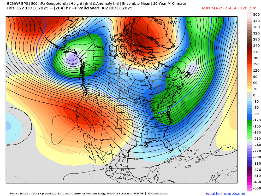
GFS looking better for the 12/10-12/12 period...there's a couple of shortwaves in there....and those won't be figured out until later, but good things happen when we amplify that western ridge a bit like on the 18z run.
-
First Winter Storm to kickoff 2025-26 Winter season
ORH_wxman replied to Baroclinic Zone's topic in New England
Hoping model guidance underestimates the density of this cold dome over us tonight...could a make a difference when we're talking like 1C in the BL. Guess we'll see on the 00z and 06z runs. -
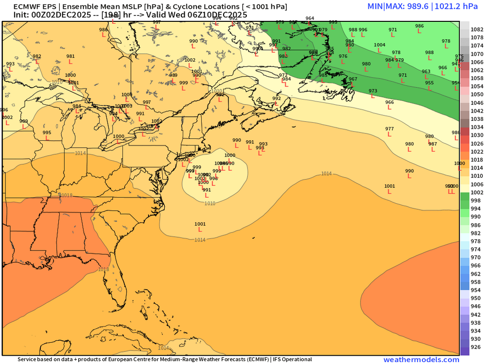
EPS is def more aggressive than other guidance trying to get a few inches in here on Saturday. A potential bigger threat would be middle of next week around the 10th-11th....but that one is all over the place. Lets see if we can amplify that ridge a little more out west....because we have a nice -NAO and some low heights in SE Canada which bodes well for actually trying to hold a high in place.
-
First Winter Storm to kickoff 2025-26 Winter season
ORH_wxman replied to Baroclinic Zone's topic in New England
NAM coming in a little flatter so far than 12z -
First Winter Storm to kickoff 2025-26 Winter season
ORH_wxman replied to Baroclinic Zone's topic in New England
It’s def had a cold bias in the medium range the last few years. It especially does when we’re talking these SWFE or WAA type storms. The old euro actually had a slight warm bias in the medium range but it was still the best model by a lot.


