

ORH_wxman
-
Posts
93,095 -
Joined
-
Last visited
Content Type
Profiles
Blogs
Forums
American Weather
Media Demo
Store
Gallery
Everything posted by ORH_wxman
-
It's still there but it gets ground up by low heights to our northeast. I actually thought it might improve at first because it was lsightly better out west....but the vortex to our northeast keeps the flow too flat to allow the WAA to get going.
-
2007 actually pulled it off in Boston believe it or not....they didn't get a real snow event until the 12/13 storm (interior N of pike had some in the 12/3 event)
-
Yeah seeing Virginia get multiple snow events in early December doesn't help. It's one thing for that to happen in mid January but early December makes it worse. It's also pretty rare to get this type of cold for 10+ days and not get much or any snow to show for it even on the CP of SNE. We did get a stretch similar in early Dec 2018....though not quite this cold...and we got skunked while a huge storm hit VA. But fewer people were on edge in 2018....we were coming off an epic winter.
-
I think most of us are, lol. Nobody complained during our warm/snowy winters...2012-13 or 2016-17.
-
We finally have a very cold pattern with multiple chances....but if they don't produce, the knives are out even fiercer. This definitely proves it's all about the snow though....we've said it for years. 90% of the forum doesn't care if you are no longer in a torch regime or if you are -10 departures on the month if it isn't going to snow.
-
This made me LOL. The amount of psychological hedging on here is hilarious. We’ve got people calling off the Sunday storm despite it still being on a decent number of ensembles. Then canceling winter. Crazy stuff.
-
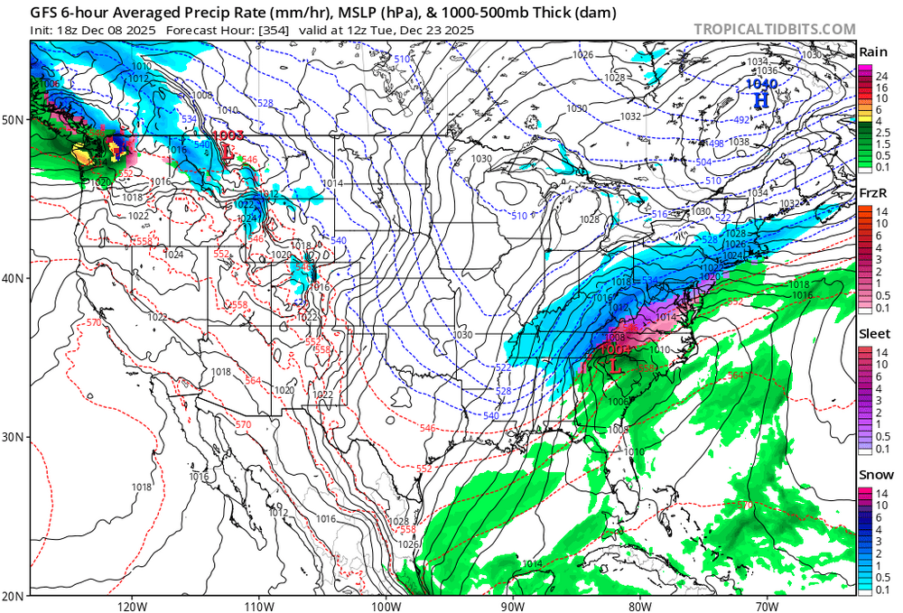
06z does get SE area with a few inches. But yeah, this one is currently all over the place on guidance.
-
Looks like GFS brought 12/14 back again.
-
Yeah even N ORH county might get some rain....or at least very wet snow that prob isn't really sticking well. Might go an inch or two of paste there as the onset looks marginally cold enough. The system itself inst very impressive. Hard to get excited when you have the midlevel center NW of Ottawa....you're trying to get moisture advection on a dry wind direction. Western slopes might do a little better in that type of setup. Someone like @wxmanmitch(Mitch in S VT) will prob get like 8-10" while 10 miles east gets a sloppy inch with some drops mixed in late.
-
Yeah EPS is still a bit dicey, but it def trended colder in the LR.
-
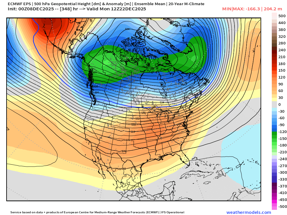
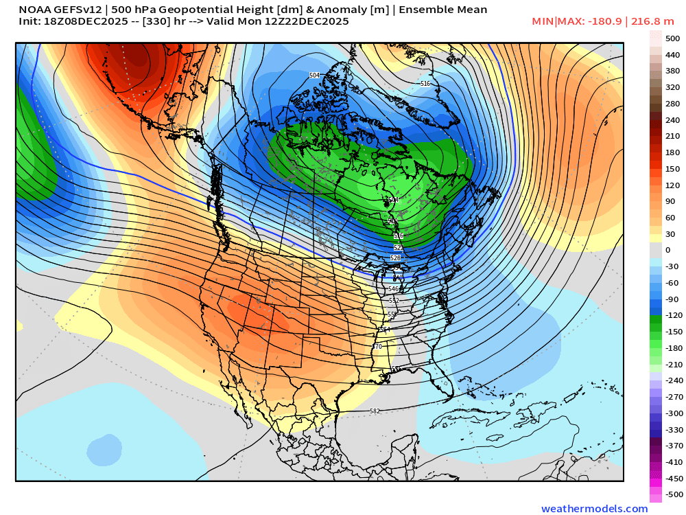
At least the ensembles are still showing that better pattern toward Xmas. 18z today vs 24 hours ago Scandi ridging retrograding as we get closer has been a theme so far this month. Also hard to torch really hard across northern tier when you have a strongly -WPO like we’ve seen.
-
Always love temps near 10F with pellets. I’d be fine with it though…plenty of snow before that. ‘94-esque….Jimmy Buffet mele kalikimaka by the time it verifies.
-
All kidding aside, that’s a high stakes pattern toward Xmas. Decent trends today of sinking that gradient south so maybe we can actually get a good winter threat near Xmas instead of flamingos and parrots flying overhead.
-
No grinch storm this run. We can all exhale
-
Yeah also some lower heights in SE Canada (they are never there these days when we need them)....in addition to the ridge being a little flatter at 132h.
-
Ridge not quite as good this run on 18z GFS....so we get a scraper on the 12/14 event.
-
Yeah probably...warm enough to melt a coating or an inch of snow most likely. Interior elevations N of pike might keep new snow (they also have a current snowpack anyway from 12/2)....but further south and east near 84 and 495 prob low 40s on Wednesday...maybe warmer even further SE.
-
May need to watch for a C-1" type deal tomorrow night as that first weakening shortwave moves through ahead of the main clipper shortwave. Could also just be a few flurries...depends if we can saturate the column enough.
-
This event is not really like last week other than maybe roughly the same line where you get some accumulation....it's weak with a lot less QPF. It'll be good for high elevations in NNE. PRob mostly a 0.15-0.30" QPF type deal outside of the upslope elevated spots which might see 0.5-0.75"
-
Given the background -PDO/Nina, we’ll almost certainly deal with west coast troughing again this winter…but I’d rather roll the dice with it in later January and February versus December. And hopefully it’s not digging into Baja…a lot more manageable when it’s a PAC NW trough.
-
That’s a good visual of how the arctic jet strengthens from Siberia to AK/N Canada as that WPO block strengthens. In addition, the stronger WPO block helps force that vortex down south of Aleutians which helps pump the PNA ridge…I think it was @Typhoon Tip who talks about their inverse correlation with a small lag.
-
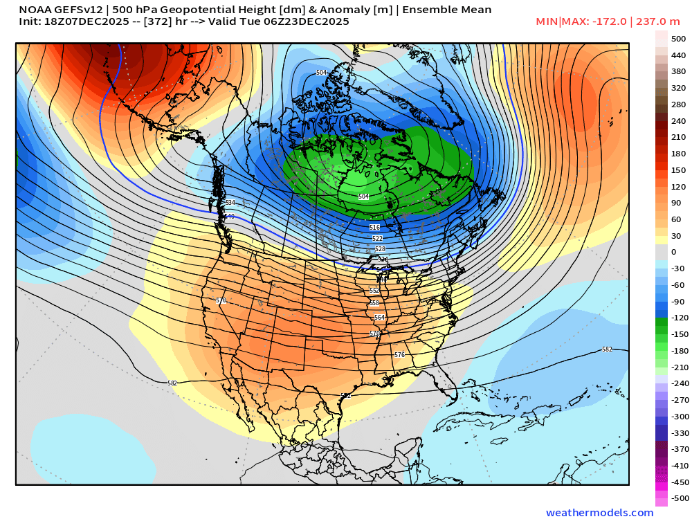
A lot of these solutions are actually in a historically good spot for D6. The key is the trend…if we a slowly amp that ridge a little more, could be a solid event for a chunk of New England…esp southeastern 2/3rds which would include your area. What we don’t want is to see the trend in the ridge regress again.
-
The preceding shortwave on the euro also gives like an inch of snow to CT/RI. Icon was more bullish on that first shortwave and other guidance basically puts it through meat grinder so it’s nothing or flurries. But can’t rule that one o it yet either…but the better focus definitely looks like 12/14
-
Actually it’s not. I’ve seen him post something looks great and it’s scraping the south coast.
-
If you start trending that ridge taller, you could quickly turn that event into something a bit bigger. It would likely be a fast mover…but those cold thickness quick hitters can sometimes be very good.


