

ORH_wxman
-
Posts
93,099 -
Joined
-
Last visited
Content Type
Profiles
Blogs
Forums
American Weather
Media Demo
Store
Gallery
Everything posted by ORH_wxman
-
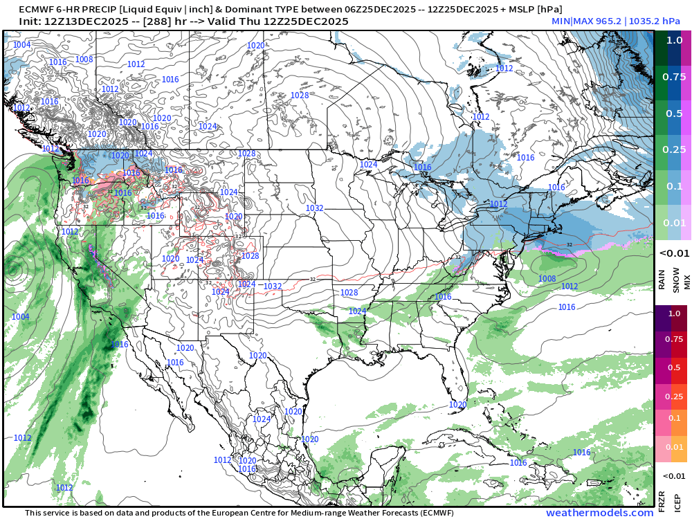
Canadian tries to get some light snow in here 12/23 into 12/24 overnight. It has a bit of a more substantial system for 12/26.
-
No they didn’t that well. That’s like 8-10” below climo. Where they got skunked a bit was the 1990s compared to ORH and BOS.
-
Ok yeah. When you burn a month in La Niña early on, usually a bad thing. There were places close to the coast in E MA that got skunked in Nov ‘71 but still recovered. Obviously rare though…Feb ‘72 was a huge month despite La Niña. Usually February is the weakest La Niña month.
-
‘71-72? November ‘71 was good but Dec ‘71 was kind of a dud for snow.
-
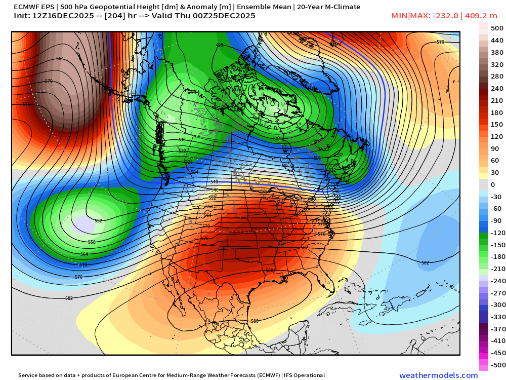
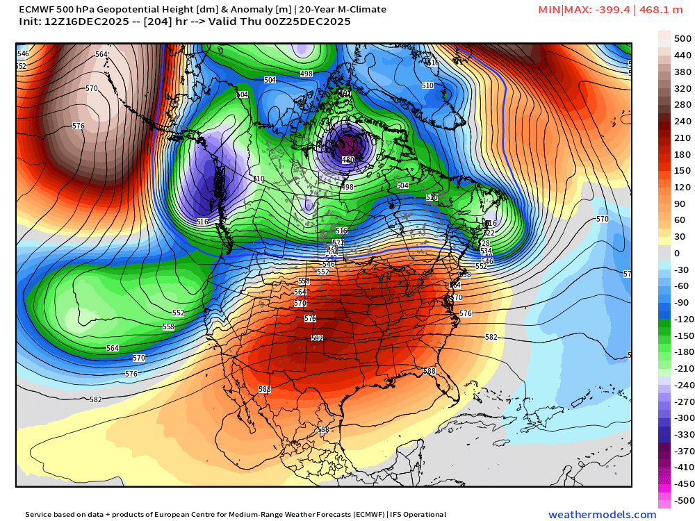
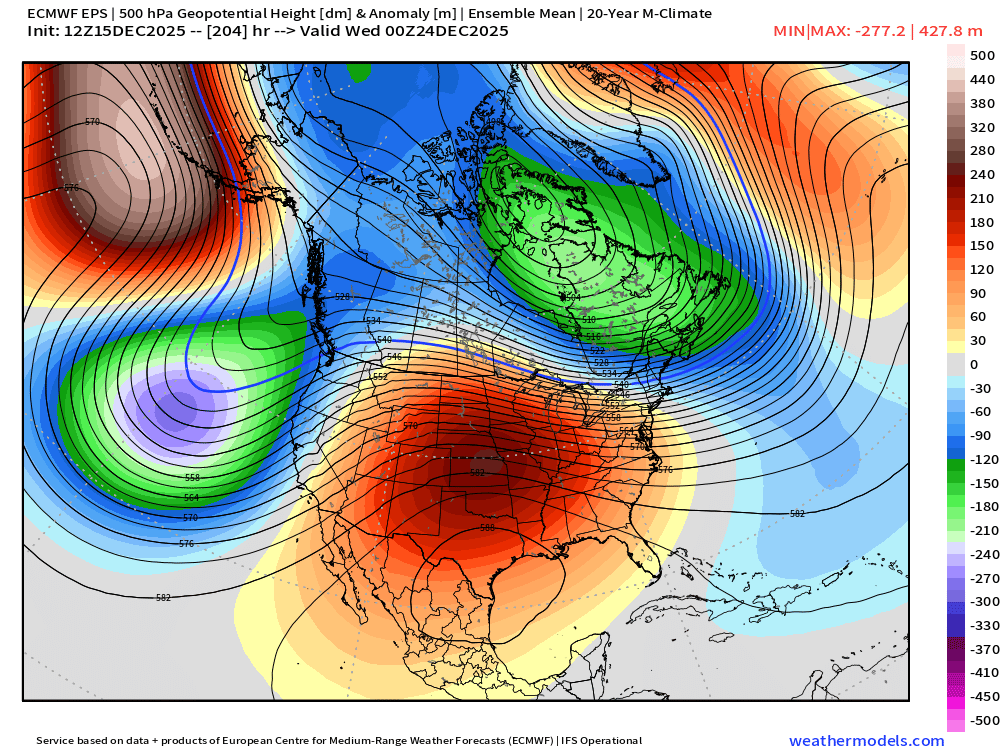
Gonna see a lot of guidance changes in the day or two IMHO for next week…you have that pig ridge in the central CONUS but it’s flat and somewhat zonal so little disturbances are FLYING across the country in the flow….makes for decent model chaos. On top of that you have some blocking trying to form in the Atlantic which adds in more uncertainty.
-
Gotta watch 12/23-24 too for a little disturbance. Obviously there’s the Xmas day threat too but not every model agrees on timing.
-
I think we’re def gonna have chances over the final 10 days of the month. It just will come with a lot of risk. There’s some weird blocking that’s been showing up too and the orientation of that will be a factor too. There aren’t a ton of analog patterns to that look. It’s kind of an unstable wave pattern there.
-
Let’s hope the weeklies are wrong. They basically furnace us the entire month of January, lol.
-
Took away our high pressure to the north for Xmas. But whatever…we’ll check back in once we’re inside a week. 12/23 wasn’t too far off from something decent either. Seems like the ridge axis was further east than other runs. Subtle but important differences. OP vs EPS
-
I read some fascinating papers and articles on the lives of human species (both Neanderthal and Homosapiens who arrived later in the period) in Europe during the 20k-80k years ago period…basically most of that was during pretty strong ice ages. They were able to figure out from bones and other artifacts that someone who survived until age 35 back then had a body more akin to someone in their 70s today. Lots of arthritis and other health issues and fast aging. Pretty amazing when you think about it. What a tough environment to live in back then. Even in much more recent times going merely back to late 19th or very early 20th century, nearly half of babies didn’t reach the age of 18. Unheard of now.
-
They also had a climate where their September was like December is in the Holocene. Back to school in snow gear?
-
Yeah I’d put Friday's system as narrowly into Grinch territory. Usually they happen closer to Xmas but if it’s 6 days out that is prob close enough. At least we have a shot at redemption though. It would be nice to get 2 in a row after we weaseled a decent snow event before Xmas last year.
-
December 14th - Snow showers or Plowable snow?
ORH_wxman replied to Sey-Mour Snow's topic in New England
Really solid event for the Cape. Especially this early in the season. Not bad to pull borderline warning criteria on Dec 14th. -
He def knows his stuff. I learned much from him my freshman year at Cornell (he was a senior there in the met department when I was a freshman)
-
It would have to be a quick clipper/redeveloper type of coastal. Not some classic Miller A or even a deeper miller B that blows up off Carolinas. Overwhelmingly the types of threats we get on a look like that would be overrunning/SWFE types.
-
I think its not a great chance, but it's definitely not zero....we have about a 2-3 day window in there from 12/23-12/25 to grab something. I think the cold is there during that stretch, but the question is can we get a nice system to run into the cold. PRob a SWFE or overrunning since you don't get many coastals with a ridge over the center of the country. But this is not a hopeless look by any stretch in New England...
-
Really no chances until maybe 12/23. Gotta hope we get a shortwave to run into the confluence which seems to be pretty stout on the ensembles…so there’s a good chance we’re at least seasonably cold during that period if not colder. But the question is whether we can get a system to fly around that ridge in the center of the country in time.
-
December 14th - Snow showers or Plowable snow?
ORH_wxman replied to Sey-Mour Snow's topic in New England
Man, mid cape is getting hammered And outer cape too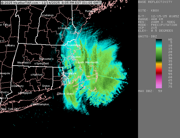
-
December 14th - Snow showers or Plowable snow?
ORH_wxman replied to Sey-Mour Snow's topic in New England
I think that’s a pretty good bet there now. At the very minimum, it’s hard to see anything less than 2” falling there and these later model runs are definitely giving a lot more upside if things break right. -
December 14th - Snow showers or Plowable snow?
ORH_wxman replied to Sey-Mour Snow's topic in New England
18z gfs ticking NW too -
December 14th - Snow showers or Plowable snow?
ORH_wxman replied to Sey-Mour Snow's topic in New England
Congrats on warning snows for SE MA on 18z NAM. -
Lock it in.
-
December 14th - Snow showers or Plowable snow?
ORH_wxman replied to Sey-Mour Snow's topic in New England
NAM has some really good snow growth on the south coast predawn and early morning tomorrow. So if they can get into some decent rates, they could fluff their way to low end warning. -
December 14th - Snow showers or Plowable snow?
ORH_wxman replied to Sey-Mour Snow's topic in New England
Looks like ICON and Reggie nudged a little north too. -
December 14th - Snow showers or Plowable snow?
ORH_wxman replied to Sey-Mour Snow's topic in New England
Yeah the NAM popped a bit late but really looked good down there.


