

ORH_wxman
-
Posts
93,099 -
Joined
-
Last visited
Content Type
Profiles
Blogs
Forums
American Weather
Media Demo
Store
Gallery
Everything posted by ORH_wxman
-
‘92-93 went from a top 5 season to pretty mediocre quite quickly once you got into central CT and southwest. It was actually below normal for snowfall once you got to NYC. Pretty amazing season though for BOS-ORH corridor and northward into your hood.
-
Actually has a rare true flash freeze event during a rain to snowstorm on that solution. Doubt it verifies but every once in a while it happens.
-
White Christmas Miracle? December 23-24th
ORH_wxman replied to Baroclinic Zone's topic in New England
Not optimistic. There’s an area of forcing knifing SE that is supposed to blossom Some snow for eastern areas later on this evening…that’s what could give a quick burst of actual half-decent rates. But it could also stay too far northeast. The dying WAA tries to rejuvenate some weaker echoes this afternoon but I am not counting on anything from that. For far eastern MA, they might try and sneak a piece of the IVT tomorrow….but that is low probability. -
We had about 12” in the 2/4/95 storm and then I think the next biggest storm all winter was maybe 2” or 3”. It was close to being historically awful if it weren’t for that one Storm.
-
Euro is pretty nice for far SW CT for Saturday. Rest of SNE is light snow that is probably getting shredded…prob 1-2” type deal.
-
White Christmas Miracle? December 23-24th
ORH_wxman replied to Baroclinic Zone's topic in New England
You need about 1.5-2” and you’ll be good. Any coatings will melt/sublimate. -
He's been in probably the worst spot in the entire region since Feb 2022. So I get it....at least the rest of us had at least a few decent events, but his area down toward Tblizz has been really bad. ORH might have been the worst spot relative to climo from 1988-1992.
-
Dude, I went 4 years without a double digit event in ORH.....think about that for a second and take into account the climo and location.
-
It's pretty good for CT, esp SW half....not good for E MA.
-
Now you are really living the ‘80s ….last winter was a small preview since it wasn’t a torch. But so far this year we’ve got well below normal temps and you get to watch the mid-Atlantic snow and then we rain on the next system and then rinse/repeat. That’s almost exactly how it went. Wasn’t that bad of a decade roughly Philly-southward.
-
I actually cant believe how cold the post-Xmas period is going to verify versus what models showed several days to a week ago....somehow, we still can't snow very much.
-
White Christmas Miracle? December 23-24th
ORH_wxman replied to Baroclinic Zone's topic in New England
The stuff in upstate NY diving SE is what most of us in SNE want to watch for later. The BGM to SW CT stuff is just going to keep fizzling...the forcing for later comes from the upstate NY batch....whether that's enough for a couple inches or not is the question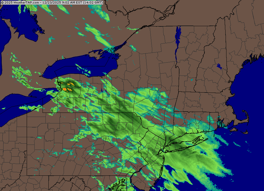
-
White Christmas Miracle? December 23-24th
ORH_wxman replied to Baroclinic Zone's topic in New England
3k NAM being pretty healthy too gives some hope though that the 12k isn’t on crack. Both NAMs show the initial WAA dying out midday east of ORH, but it regenerates a very healthy precip shield as the forcing from the northwest (that gives NNE most of their snow outside the norlun) punches in. So if they are right, we’d see a lot of blossoming precip on radar this afternoon. Esp after about 2-3pm. -
White Christmas Miracle? December 23-24th
ORH_wxman replied to Baroclinic Zone's topic in New England
Not sold yet though. Hrrr still hideous. Rap still hideous. -
White Christmas Miracle? December 23-24th
ORH_wxman replied to Baroclinic Zone's topic in New England
12z NAM came in decently healthier for this afternoon. -
White Christmas Miracle? December 23-24th
ORH_wxman replied to Baroclinic Zone's topic in New England
Might be C-1” inside of 128. Even here could struggle for an inch but that depends on if we get some better enhancement in the evening for about 2-3 hours. Won’t surprise me though if we get skunked given the last few years. -
White Christmas Miracle? December 23-24th
ORH_wxman replied to Baroclinic Zone's topic in New England
NAM being so dry is starting to be a little bit of a red flag I don’t think I’d change anything though over interior. Still prob 1-3”. Maybe if GFS and Euro jump ship. -
White Christmas Miracle? December 23-24th
ORH_wxman replied to Baroclinic Zone's topic in New England
BL gets kind of marginal down there. Prob flakes but could be white rain for a while. If you had some decent omega punching into the snow growth region, then it would prob rip. But this is a pretty weak system. -
White Christmas Miracle? December 23-24th
ORH_wxman replied to Baroclinic Zone's topic in New England
He’s so close to water which may be an issue for a time until winds go more N or NW. Light snow and 33-34 might struggle. -
That was a very cold run. Very few torches. 12/28 gets messy with ice/rain but not warm at all. That Atlantic blocking just dominates for 10 days.
-
White Christmas Miracle? December 23-24th
ORH_wxman replied to Baroclinic Zone's topic in New England
Euro a couple runs in a row trying to show a little enhancement in E MA tomorrow evening…maybe someone can crack 3” if that happened. Prob in the 128 belt to maybe 495..esp N of pike. Then there’s still the OES sig as the IVT rotates S and veers the winds back N for a time which puts the Cape into a decent spot. -
There are still a significant number of ensemble members on both GEFS and EPS that hammer southern New England. Lot of spread. Honestly, anything is kind of gravy from that system as 2 days ago it looked like a rainstorm except way up in far NNE.
-
Yeah it doesn’t happen too often but this is admittedly a weird setup. We want to see ensembles tighten before really getting a good handle. The mean still has decent precip up into NNE so there’s a lot to spread.
-
It actually eroded the northern edge but the heavy stuff bumped a little north…which makes sense. It’s basically tightening the gradient. Prob a sharp cutoff in this system.
-
GFS continues to be mostly a whiff for 12/26-27 but it’s been creeping back north.


