ORH_wxman
-
Posts
93,099 -
Joined
-
Last visited
Content Type
Profiles
Blogs
Forums
American Weather
Media Demo
Store
Gallery
Everything posted by ORH_wxman
-
January 2026 regional war/obs/disco thread
ORH_wxman replied to Baroclinic Zone's topic in New England
We’ve talked about this before, but there’s probably some perfect chain of events that produces a sub-950 bomb southeast of LI starting from relatively higher pressure….preceded by some sort of high-thermal gradient overrunning scenario that lasts 24+ hours before the slow moving shallow trough is injected with polar/arctic energy, deepens extremely rapidly, and produces 5-foot totals once you add the entire thing up. Yeah…1 in 500 years maybe? But it’s not zero. -
January 2026 regional war/obs/disco thread
ORH_wxman replied to Baroclinic Zone's topic in New England
For me, that bigger storm can win but it has to be pretty rare. Taking a 15” storm that melts in 3 days over a handful of 5-6” events with prolonged cold is an easy no for me. But if we’re talking a 30-burger over 3 foot-longs, sure…the 30-burger is pretty special. -
Ice Ice Baby December 28-29 Storm Discussion
ORH_wxman replied to Baroclinic Zone's topic in New England
Radar looks good
-
January 2026 regional war/obs/disco thread
ORH_wxman replied to Baroclinic Zone's topic in New England
Most people here would probably take 2-3 storms that add up to 25” with long duration colder temps than a 19” storm that melts away in 4 days. But I can see those who just enjoy the storm picking the 19-spot. Obviously if we waste a good pattern with very little snow, we’d all take the 19 burger. -
Ice Ice Baby December 28-29 Storm Discussion
ORH_wxman replied to Baroclinic Zone's topic in New England
Looks pretty decent south side of BAF/CEF
-
January 2026 regional war/obs/disco thread
ORH_wxman replied to Baroclinic Zone's topic in New England
1/6 could morph into something worth tracking if we can get it inside 6 days. The larger signal is 1/8-9 but that has a ways to go. But overall a good pattern coming up. Nice to have in early January for once. Feels like we’ve been fighting garbage patterns in early January so often over the last decade or even longer. We had a lot of good early Januarys in the 2009-2014 time frame. Since then I feel like maybe only 2018…maybe 2024 if we want to count that one threat on 1/7 but it really wasn’t a cold pattern at all. -
January 2026 regional war/obs/disco thread
ORH_wxman replied to Baroclinic Zone's topic in New England
Yeah euro still generates a system on 1/8-1/9 but it’s a bit strung out and weak going almost due north and scraping eastern areas. It doesn’t take much mental gymnastics to see that thing being much stronger and more coherent. The PNA ridge is pretty amplified which is going to want to force a lot of energy to pile up around the base of the trough.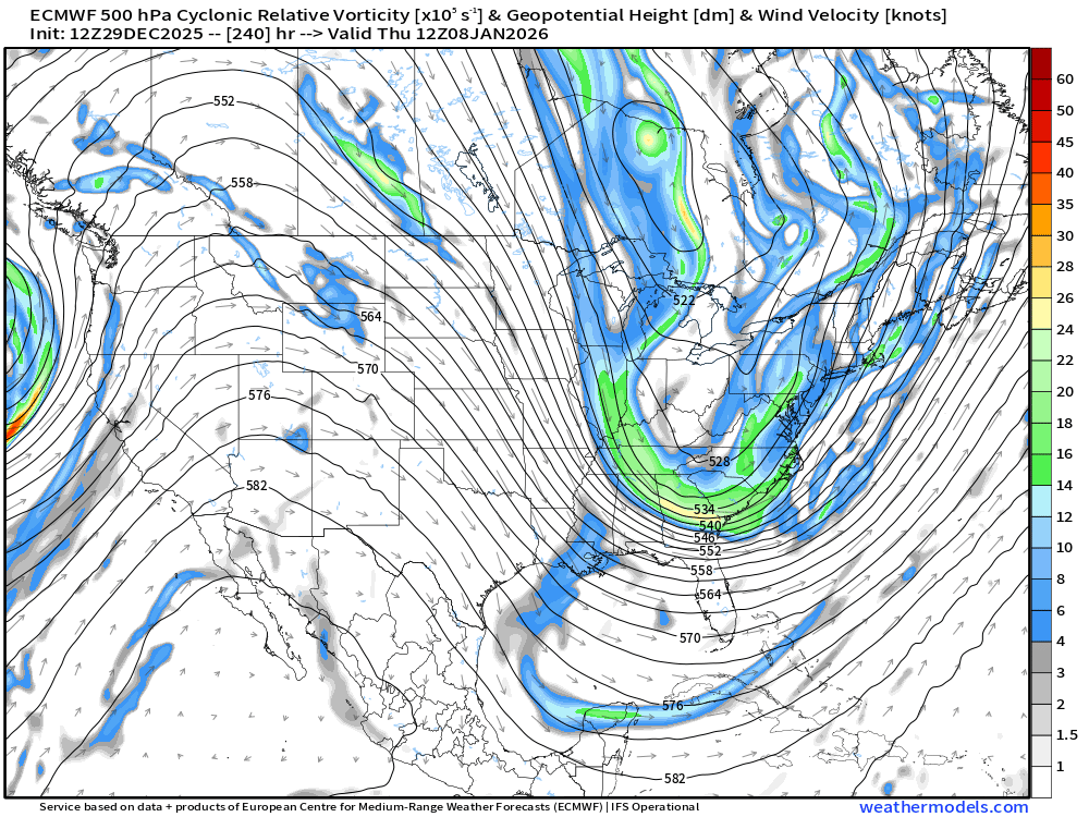
-
January 2026 regional war/obs/disco thread
ORH_wxman replied to Baroclinic Zone's topic in New England
Yeah the NESIS maps are good for general coverage idea. They are often wayyyyy too conservative in the jackpot regions. The Kocin maps in the book are much better at showing those. -
January 2026 regional war/obs/disco thread
ORH_wxman replied to Baroclinic Zone's topic in New England
1/6 looks decent on Euro today. Moderate 3-6 type event. -
January 2026 regional war/obs/disco thread
ORH_wxman replied to Baroclinic Zone's topic in New England
That New years weak clipper is trying to get slightly enhanced in eastern areas. Wonder if someone can pick up a couple inches. Still just expecting a coating but 1-2 isn’t impossible. -
January 2026 regional war/obs/disco thread
ORH_wxman replied to Baroclinic Zone's topic in New England
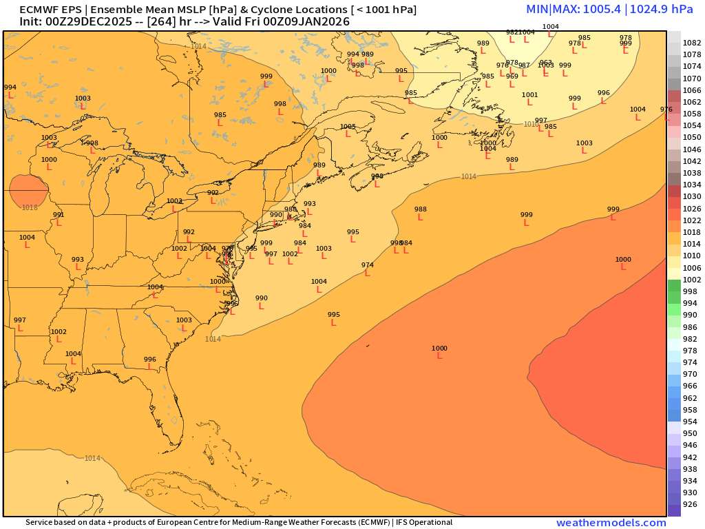
Has another period of interest a few days later too. Obviously the further you go out, the more diffuse the mean gets but that’s definitely still something.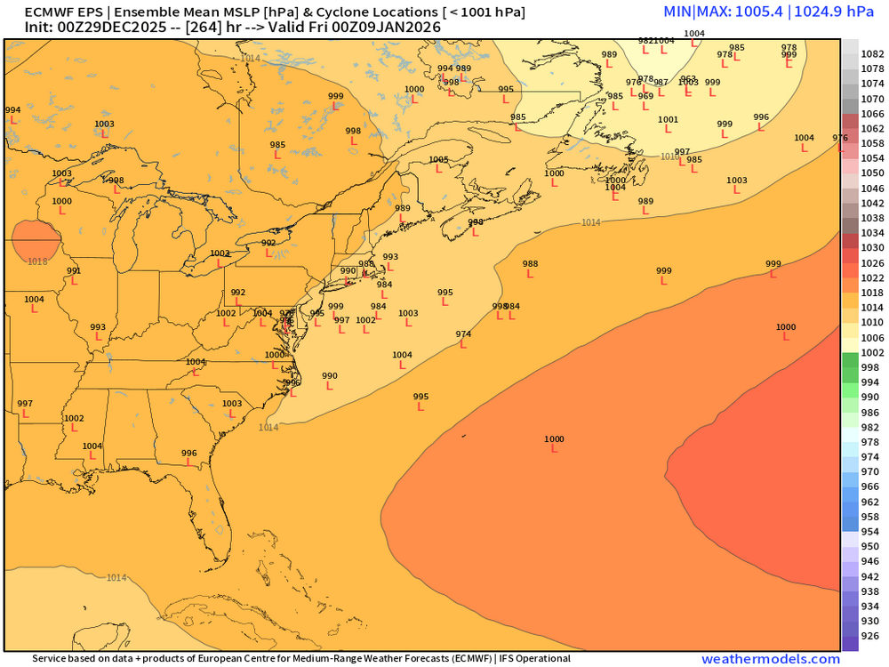
-
January 2026 regional war/obs/disco thread
ORH_wxman replied to Baroclinic Zone's topic in New England
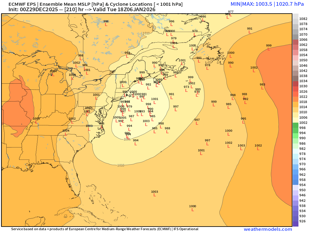
This is pretty solid for 200+ hours…forget the OP runs for a bit…maybe it doesn’t work out but you have a very definitive signal there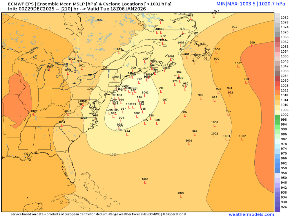
-
January 2026 regional war/obs/disco thread
ORH_wxman replied to Baroclinic Zone's topic in New England
Which part of Haverhill? Lol. I think the northern side is where there was 7” of sand. Massive cutoff near there. -
January 2026 regional war/obs/disco thread
ORH_wxman replied to Baroclinic Zone's topic in New England
Oh yeah, I understand it. That’s why I posted it. It is still irrational behavior in an objective/scientific context but I understand why people get panicky about not seeing blizzards on 300 hour OP runs. The lack of success in the KU department recently causes irrational behavior to manifest itself in that manner. I also think the utter glut of storms in the 2010s also produced irrational behavior in terms of expectations. We expected every shortwave to bomb out and give us 8-12” if not something bigger….and for a while, we kept pulling the slot level and ringing up triple 7s. It’s gone the complete opposite direction now but both outcomes are unsustainable. -
January 2026 regional war/obs/disco thread
ORH_wxman replied to Baroclinic Zone's topic in New England
I think that’s placing too much precision on an analog. If all you knew is that we’d get a bomb near the cape with plenty of cold, Wed roll the dice every time and not worry about the nuances. -
January 2026 regional war/obs/disco thread
ORH_wxman replied to Baroclinic Zone's topic in New England
I do…if operational runs aren’t showing 288 hour blizzards, people get antsy regardless of whether the longwave setup looks nice….its a weird manifestation of the last 5 years. Nobody used to give a shit about whether we had 300 hour storms but now a significant portion of the forum gets anxiety over it. It’s probably because of the lack of KUs in that time period. Somehow, seeing them on the OP runs in clown range is some kind of crutch I guess. -
January 2026 regional war/obs/disco thread
ORH_wxman replied to Baroclinic Zone's topic in New England
If DC gets hit big is usually is less impressive here but there’s been plenty that hit us very hard that hit NYC too (Feb ‘78, April ‘82, Jan ‘11, Jan ‘18, etc off the top of my head) -
Ice Ice Baby December 28-29 Storm Discussion
ORH_wxman replied to Baroclinic Zone's topic in New England
Anytime I see 925-950ish going above 0C relatively quickly, I sell big ice accretion. You’d need something super inverted like 20F at the sfc to overcome the warm drops. -
Ice Ice Baby December 28-29 Storm Discussion
ORH_wxman replied to Baroclinic Zone's topic in New England
I hated that storm but always love your account of it. We almost got our pack wiped in that one. Only reason we didn’t was because there was so much sleet and water equivalent in it from like 5 previous high QPF events that had started with the Dec 29-30, 1993 storm. But it was mowed down to about 2” of glacier. -
Ice Ice Baby December 28-29 Storm Discussion
ORH_wxman replied to Baroclinic Zone's topic in New England
This tends to work better when the pack is deep and higher water content. It takes time to heat water…this type of pack prob gets pretty ripe quite quickly once dews reach 38-40F. You're area got a nicer dose of QPF so the valleys there could be tough to wipe out. -
Ice Ice Baby December 28-29 Storm Discussion
ORH_wxman replied to Baroclinic Zone's topic in New England
I dunno, I really think it depends how long temps are above 40F…in your area to my area, there’s a decent chance it wipes the pack. Prob gonna be 12+ hours of 40+ dews. Not a lot of water in the pack either (though my bottom layer from 12/23 is kind of dense). Western CT up into ORH county might keep it though as they spend less time above 40F. If we had like an inch of water in the pack then this wouldn’t wipe it out, but this is not that type of pack. -
January 2026 regional war/obs/disco thread
ORH_wxman replied to Baroclinic Zone's topic in New England
Gonna be a miller B while you’re gone just to give you one more round in Ray’s beast shed. -
Ice Ice Baby December 28-29 Storm Discussion
ORH_wxman replied to Baroclinic Zone's topic in New England
I also don’t think the accretion will be overly efficient in this type of setup. When the cold layer is so shallow like this, the liquid drops are not as supercooled so they won’t freeze as quickly on contact. In icing events where we have robust cold up into the 925-950 layer, that’s when the accretion is usually much more efficient. It prob will start pretty icy but then then it will get pretty marginal. -
-2 at AFN while ORH is 20F. About as fake as it gets, lol. But there will def be some stubborn cold overnight tonight that will cause icy spots.
-
January 2026 regional war/obs/disco thread
ORH_wxman replied to Baroclinic Zone's topic in New England
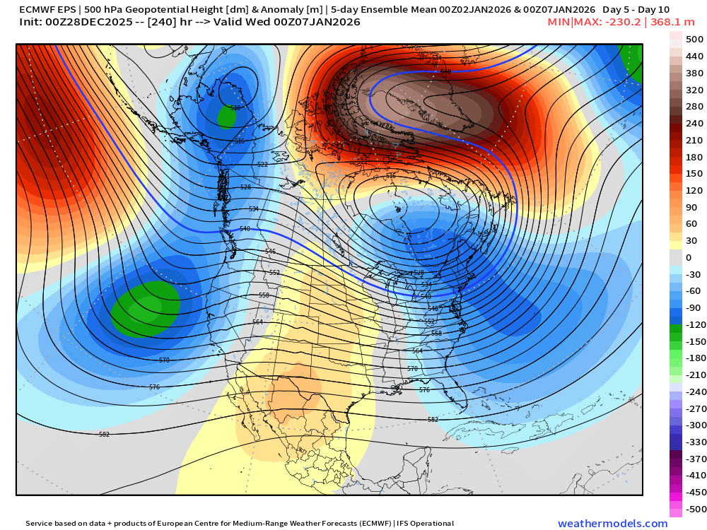
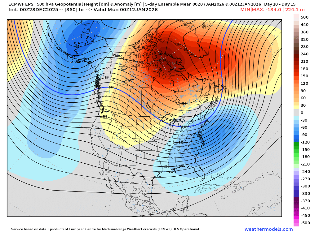
Looks too flat now for much if anything. Maybe it comes back but I’d forecast flurries right now. Pattern looks pretty awesome though beyond that. Here’s day 5-10 and then day 10-15 respectively on EPS