

ORH_wxman
-
Posts
93,099 -
Joined
-
Last visited
Content Type
Profiles
Blogs
Forums
American Weather
Media Demo
Store
Gallery
Everything posted by ORH_wxman
-
January 2026 regional war/obs/disco thread
ORH_wxman replied to Baroclinic Zone's topic in New England
Pretty good snow growth in this band. This will do it for this C-1” event.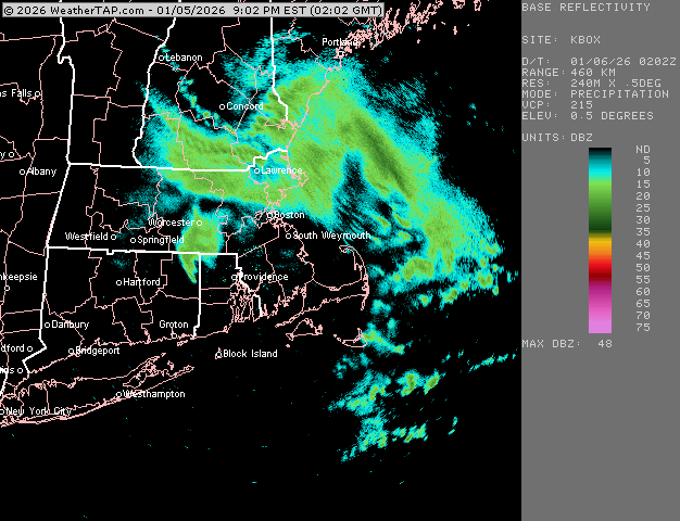
-
January 2026 regional war/obs/disco thread
ORH_wxman replied to Baroclinic Zone's topic in New England
Well there is nothing until next week…the pseudo-cutter CAD storm this weekend which is prob just cold rain down here…then the pattern looks a lot better starting around 1/14-15ish. So any threats are gonna be D10 or longer. -
January 2026 regional war/obs/disco thread
ORH_wxman replied to Baroclinic Zone's topic in New England
The storm misses are close calls too which is a good sign. 18z GFS had a few just wide right. -
January 2026 regional war/obs/disco thread
ORH_wxman replied to Baroclinic Zone's topic in New England
Snowing steadily with a solid coating. Looks like round 1 about to finish. Should get another batch this evening. -
January 2026 regional war/obs/disco thread
ORH_wxman replied to Baroclinic Zone's topic in New England
NAM is tucky -
January 2026 regional war/obs/disco thread
ORH_wxman replied to Baroclinic Zone's topic in New England
Yeah if you put up -5 or -6 weeks in mid to late January, you're likely talking below zero temps several occurrences at night even down in SNE. -
January 2026 regional war/obs/disco thread
ORH_wxman replied to Baroclinic Zone's topic in New England
What’s your low there so far? SLK can put up -25F or colder several nights in a month during some good cold outbreaks. Plus those cold air advection days where it’s near 0F for a high. -
January 2026 regional war/obs/disco thread
ORH_wxman replied to Baroclinic Zone's topic in New England
Pretty nice setup. Ridge gets a little sliced off in BC but this is just round one…ridge then rebuilds a little further west and we’d have several more shots in the following 5-10 days with that longwave look. Hopefully we can cash in….but for D10 and beyond, this is all we can ask for at the moment.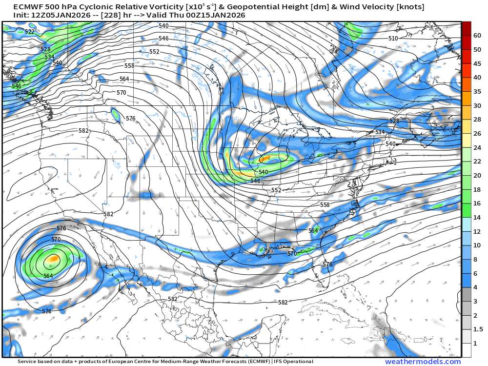
-
January 2026 regional war/obs/disco thread
ORH_wxman replied to Baroclinic Zone's topic in New England
No, prob ZR though in your area...maybe some IP too if the cold gets deep enough in the boundary layer. -
January 2026 regional war/obs/disco thread
ORH_wxman replied to Baroclinic Zone's topic in New England
@Typhoon Tip, 12z Euro showing a really good western ridge and some shortwave activity diving down the east side of it...pretty explosive setup during that 1/15 time range. -
January 2026 regional war/obs/disco thread
ORH_wxman replied to Baroclinic Zone's topic in New England
Warmest day of the week I think....prob mid 40s? We have southerly flow, but it's weak. Cant get the real warm stuff in the Delmarva up into here with that weak flow...then flow turns back N overnight Friday night. -
January 2026 regional war/obs/disco thread
ORH_wxman replied to Baroclinic Zone's topic in New England
12z Euro sags the sfc front south of SNE during the day on Saturday as well. No warm sector happening Saturday night/Sunday at least over the interior...might sneak some parakeets onto the Cape. -
January 2026 regional war/obs/disco thread
ORH_wxman replied to Baroclinic Zone's topic in New England
1/14 would be a bonus if we got something good that early. -
January 2026 regional war/obs/disco thread
ORH_wxman replied to Baroclinic Zone's topic in New England
Before that pattern sets up there is a brief window for a good coastal. Prob between about 1/14-1/18 or so. -
January 2026 regional war/obs/disco thread
ORH_wxman replied to Baroclinic Zone's topic in New England
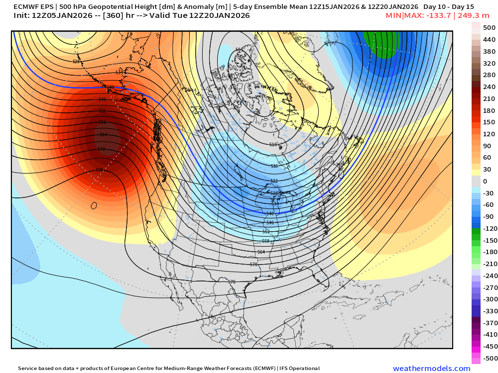
Pattern looks to be pretty favorable by mid-month now. Hopefully something pops ala 12z Euro today. Ensembles still showing a nice pattern out in the extended. There’s your +TNH pattern…basically -EPO and a near neutral to negative PNA.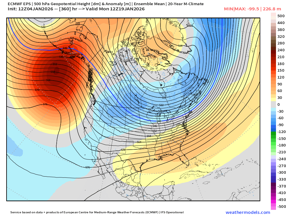
-
Yes but it’s just prior to the WSR 88-D Doppler radars being installed. So you don’t get the banding detail like you would even a couple years later. Just search for that storm in YouTube and you’ll see a ton of weather channel clips that show the radar loops.
-
January 2026 regional war/obs/disco thread
ORH_wxman replied to Baroclinic Zone's topic in New England
I think last year and this year are more closely 1980s. On the colder side but less snow. The 2020-2023 period was just us cosplaying Virginia winters. -
January 2026 regional war/obs/disco thread
ORH_wxman replied to Baroclinic Zone's topic in New England
Btw we had about 3 or 4 tenths here this morning. Just a minor refresher. Looks nice. Would be nice to get a bigger system. Tuesday might try to give a couple inches. -
January 2026 regional war/obs/disco thread
ORH_wxman replied to Baroclinic Zone's topic in New England
Might set the stage for Wed morning…been watching the potential for some nasty black ice and light freezing rain for that time due to some mesolow type stuff going on that starts on Tuesday and may go into Wednesday. . -
January 2026 regional war/obs/disco thread
ORH_wxman replied to Baroclinic Zone's topic in New England
Dec 5-7, 1981 was a big storm for eastern MA and RI. March 29, 1984 was big over interior SNE. A couple storms in Jan 1987 were quite good over interior as well…I believe both are in the Kocin book (Jan 22, 1987 and Jan 1-2, 1987 as a near-miss). Also don’t forget April 1982. -
January 2026 regional war/obs/disco thread
ORH_wxman replied to Baroclinic Zone's topic in New England
Funny too that a lot of 80s winters had pretty cold Decembers with light snowfalls. Then the season would shit the bed. -
January 2026 regional war/obs/disco thread
ORH_wxman replied to Baroclinic Zone's topic in New England
Icon also turns the 1/10 storm into a SWFE. -
January 2026 regional war/obs/disco thread
ORH_wxman replied to Baroclinic Zone's topic in New England
Yeah the cold has been pretty impressive too. Early season helps a lot with sun angle but ripping off like a -5 departure over 5 weeks doesn’t hurt either. That combo is great for trying to protect fairly thin snow packs. We’ve had snow OTG for so many days even though our total is a little BN to date. Your area has done a little better in the snow department because of 12/26 but still same general idea. -
January 2026 regional war/obs/disco thread
ORH_wxman replied to Baroclinic Zone's topic in New England
18z gfs def playing the mesolow game next Tuesday night/Wed morning. Joining some of the other guidance. This could make it kind of nasty from Ray’s area down through interior SNE with a bit of icing. -
January 2026 regional war/obs/disco thread
ORH_wxman replied to Baroclinic Zone's topic in New England
I’ve always said that a lot of the usual suspects will whine until we get a big hit. It doesn’t matter if the pattern looks identical to Feb 2013 or Jan 2011 or Feb 2015. They will scoff and whine unless the storm is on the doorstep. That’s just the way it works. But yeah, it’s a solid look. Details TBD. I’m actually keeping my eye on the 1/7 event which a lot of mesos are starting to show a lot of CAD and even a mesolow…could be some ice issues over interior, esp if a mesolow gets going (and some snow north of that into CNE…Rgem/Ggem has snow into SNE but likely too cold.)


