ORH_wxman
-
Posts
93,099 -
Joined
-
Last visited
Content Type
Profiles
Blogs
Forums
American Weather
Media Demo
Store
Gallery
Everything posted by ORH_wxman
-
January 2026 regional war/obs/disco thread
ORH_wxman replied to Baroclinic Zone's topic in New England
Might deliver this run but even if it doesn’t, that’s a huge positive trend. -
January 2026 regional war/obs/disco thread
ORH_wxman replied to Baroclinic Zone's topic in New England
Still there but hard to really talk coherently about it given it’s like 9 days out. A lot will depend on what happens with the first one. -
January 2026 regional war/obs/disco thread
ORH_wxman replied to Baroclinic Zone's topic in New England
Next Friday is basically this on model guidance: Interested: GFS, GEFS,Euro Skynet, GFS Skynet Disinterested: Euro, EPS, GGEM, Ukie Icon is maybe on the fence. -
January 2026 regional war/obs/disco thread
ORH_wxman replied to Baroclinic Zone's topic in New England
To be fair to the black ice weenies, you talk about DAW like it’s ISP. -
January 2026 regional war/obs/disco thread
ORH_wxman replied to Baroclinic Zone's topic in New England
Yeah I’m not trusting the GFS when it’s basically on an island for next Friday. I’ll want to see other guidance get back on board for that system. Although both skynet models like next Friday too. Maybe Arnold comes through. -
January 2026 regional war/obs/disco thread
ORH_wxman replied to Baroclinic Zone's topic in New England
Roaring here too in Holliston (though I’m on a hill southwest facing.) -
January 2026 regional war/obs/disco thread
ORH_wxman replied to Baroclinic Zone's topic in New England
Yeah, it is unfair to grade someone's forecasting ability if they aren't actually issuing forecasts on here. Talking about the pattern isn't issuing a forecast. You can disagree with their pattern analysis, but it's not fair to call it a forecast if they were just analyzing an ensemble run or a model run. Some mets and plenty of amateurs do issue forecasts from time to time, and those are fair game to critique as well. But I think people should be clear about what they are critiquing. Model analysis is not the same as an actual forecast. And I also don't think it is an indictment on anyone's skill if they post more or less depending on what type of sensible wx the models are showing. I'm sure most mets on here have a lower post rate when we have a vortex over AK and a zonal mild flow in mid-winter. I know I do. I could keep posting about whether the zonal flow might change enough to give us high temps of 54F instead of 47F, but that is about as interesting to me as watching paint dry, so I normally refrain. There are others on here to pick up the slack on that type of discussion if I don't want to do it. Additionally, I think "pattern talk" is much more likely to occur during periods where there are no imminent threats. We're searching for the next "interesting period". We all know that in rapid-fire stretches of winter storms, we are not constantly posting much about longwave patterns or what some vague D11-15 signal might produce....we're dissecting smaller scale features over a short term storm threat, and maybe tracking another one in the medium range. All of the oxygen gets sucked up during those times with the threats themselves and not pattern talk. -
January 2026 regional war/obs/disco thread
ORH_wxman replied to Baroclinic Zone's topic in New England
I think the D7 event is a long shot (but it does have a decent ceiling if it can back into us)....the one after seems like it has more OP hits including the skynet suite. EuroAI really liked the 1/18-19 system for multiple runs recently. All of this is still in marginal clown range, but its the best we've seen all winter in terms of higher end threats. -
January 2026 regional war/obs/disco thread
ORH_wxman replied to Baroclinic Zone's topic in New England
I think the most important takeaway from the 12z suite is that the longwave ridge is onshore out west or right on the coast and it has a couple pulses up and down…when you have that longwave setup, you’re putting yourself in the firing range so you’re going to get some legit chances with even a little bit of wiggle room. That’s why we’re seeing hits on different models that all look a slightly different with the shortwave evolution. But they all produce something because the longwave pattern wants to put a storm system near the east coast. Hopefully we don’t see that longwave look degrade as we get closer. -
January 2026 regional war/obs/disco thread
ORH_wxman replied to Baroclinic Zone's topic in New England
Euro likes 1/17….just to trick everyone. It’s really the 1/18 storm but the lead shortwave takes the energy and does a little bomb just SE of us. -
That is a horrific map. Not sure what they were looking. Usually the NESIS maps are good for looking at the general idea of the snow distribution despite being too conservative, but this map is completely wrong and way too aggressive with the snow in SNE and NJ/NYC
-
January 2026 regional war/obs/disco thread
ORH_wxman replied to Baroclinic Zone's topic in New England
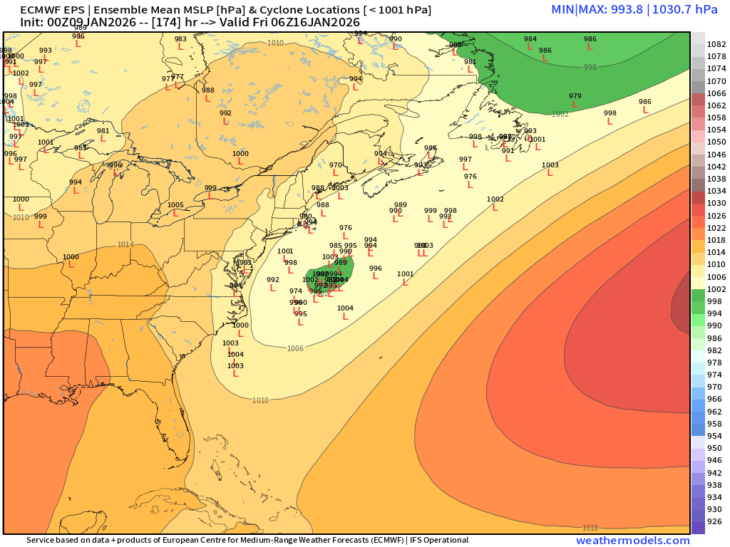
The weekend system also kind of sneakily morphed into a pretty low QPF event. Almost that shredded SWFE look on the precip. The bulk of the WCB misses to our east and the CCB is way back up in eastern Ontario/western Quebec. Leaves us kind of in a dead zone of forcing in between the two. -
January 2026 regional war/obs/disco thread
ORH_wxman replied to Baroclinic Zone's topic in New England
Yeah as the storm intensifies offshore, it pulls in that arctic airmass…that high is moving E at the same time. I honestly have no idea if we even get a storm, but assuming we got something semi-depicted, it could be one of those systems that starts as pure paste (or even mixed/rain on coastal plain) and then it advects in much colder air as it gets drawn into the CCB. The biggest big dog in Mar ‘18 kind of did that. First few inches were like spackle here and then we ended up with 2 feet, the latter 20” was mostly pure powder as temps plummeted in the CCB. At this point, I’d take just a minimal warning event and I’d consider that a huge win if we somehow squeezed out that type of event next Friday. -
January 2026 regional war/obs/disco thread
ORH_wxman replied to Baroclinic Zone's topic in New England
I agree. I’d think that would produce something. It could be of those systems that takes a wide left turn but really comes back N and slams New England if you time the neg tilt correctly. -
January 2026 regional war/obs/disco thread
ORH_wxman replied to Baroclinic Zone's topic in New England
Shit snow totals but I’m on like day 33 of snow cover, lol. I don’t think I’ve had more than 4” OTG at any time either. Normally 33 days at this point would mean a great start to the winter with likely multiple warning events, but not this year. As much as I hate brown frozen ground, if we are going to get a decent storm next Friday, then I wouldn’t mind starting clean. -
January 2026 regional war/obs/disco thread
ORH_wxman replied to Baroclinic Zone's topic in New England
MLK weekend itself looks like there is potential. -
January 2026 regional war/obs/disco thread
ORH_wxman replied to Baroclinic Zone's topic in New England
Next week would def be a nice bonus if we can get that wave to blow up on the frontal boundary draped just east of us. There may be another threat behind that on MLK weekend too it seems…but we’re gonna need to figure out the first one
-
On deep layer easterly flow events, you’ll get initial land convergence in SE MA with a slight elevation rise too in interior SE MA but then it goes back down into E RI before you get the bigger upslope into NW RI and far NE CT. I wonder if absent any midlevel enhancement, they just get stuck in subsidence between the land convergence/slight upslope in interior SE MA and the upslope further west.
-
January 2026 regional war/obs/disco thread
ORH_wxman replied to Baroclinic Zone's topic in New England
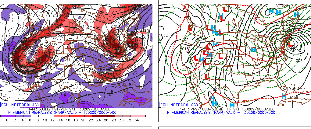
OR we could go the Feb 2013 route also with a ridge hundreds of miles offshore the PAC...lol. Granted, this was slower flow
-
January 2026 regional war/obs/disco thread
ORH_wxman replied to Baroclinic Zone's topic in New England
Just give me a damned storm like this....doesn't need to be a fooking Kocin cookbook pattern with perfect ridge placements....this damned ridge was like hundreds of miles offshore the PAC.....we can't buy these kind of systems lately and it has nothing to do with phasing or fast flow....this type of system was fast flow embedded shbortwave. -
January 2026 regional war/obs/disco thread
ORH_wxman replied to Baroclinic Zone's topic in New England
We had multiple BM track rainstorms in January 1958. A lot of people are very ignorant of weather history....but that is my forte, so it's easy to push back on. Multiple things can be true at once (which is also hard for many)....you can be warming, but also not have every event be some new shocking paradigm. Places like interior New England are likely never warming enough to become a DCA/BWI climate....perhaps that happens to NYC at some point....but even that could be a stretch. -
January 2026 regional war/obs/disco thread
ORH_wxman replied to Baroclinic Zone's topic in New England
SE ridge with frigid cold to the north always makes those more likely but you can easily get high-QPF snow events too in that. -
January 2026 regional war/obs/disco thread
ORH_wxman replied to Baroclinic Zone's topic in New England
It's been a pretty big switch this year with the WPO keeping on wanting to revert to a big negative phase. Last year, we were able to break the streak of it being largely positive, but it was still not strongly negative....it was enough with the -EPO to give us slightly BN temps. But this year, we had a raging -WPO much of December, and even when it flipped early here in January, it quickly wants to set up shop again next week. -
January 2026 regional war/obs/disco thread
ORH_wxman replied to Baroclinic Zone's topic in New England
A little bit of Wilton on that look late in the game (after maybe a few shots at a coastal in the D10-13 range)....some people might get a little scared of the orange colors at H5 getting close to NE, but that is a frigid northern tier look with that WPO/AO domain look.
-
January 2026 regional war/obs/disco thread
ORH_wxman replied to Baroclinic Zone's topic in New England
Honestly, I think a way CC can help is you'll get these mega juiced systems when the longwave pattern lines up correctly....you'll have some season where it goes bonkers (ala 2015 in E MA)....all the extra moisture just getting freight-trained into New England with a cold dome overhead.