

ORH_wxman
-
Posts
93,099 -
Joined
-
Last visited
Content Type
Profiles
Blogs
Forums
American Weather
Media Demo
Store
Gallery
Everything posted by ORH_wxman
-
January 2026 regional war/obs/disco thread
ORH_wxman replied to Baroclinic Zone's topic in New England
Most are focused on snow understandably, but the pattern is pretty good for a potential legit arctic cold blast....so if we're looking for sub-zero temps, this is the type of pattern you want. Ensembles are focusing near MLK weekend and maybe just after.....note the absolutely zonked WPO ridge and a bit of -AO retrograding from Scandi/Ural ridging....thats going to shove pure Siberian arctic into central and SE Canada.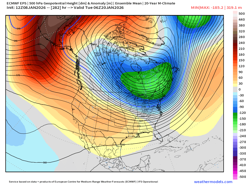
-
January 2026 regional war/obs/disco thread
ORH_wxman replied to Baroclinic Zone's topic in New England
So when it ultimately phases in and ruins our chance at a good event....we can blame the "new regime", even though the "new regime" is hostile to phasing. I can already see the posts now. -
January 2026 regional war/obs/disco thread
ORH_wxman replied to Baroclinic Zone's topic in New England
Some hits showing up on the 12z Euro today. The KU-or-bust folks will still be searching though. -
January 2026 regional war/obs/disco thread
ORH_wxman replied to Baroclinic Zone's topic in New England
Most guidance seems to have two shortwaves coming down near mid-month that we can sort of follow now....but that can obviously change at this lead time. The second one looks better to me....which would prob be in the 1/15-1/17 time range (timing varies by model guidance and cycle)....the first one looks like it's struggling with wave spacing and also antecedent airmass is poorer. So if we happen to grab anything out of the 1/13-1/14 period, it's pure gravy IMHO. -
SE MA cleaned up unbelievably in that 15 year stretch....they were easily the most AN for snowfall anywhere in New England during that timeframe. They are a decent spot for big storms already, but those years just went crazy bonkers with the frequency of biggies.
-
January 2026 regional war/obs/disco thread
ORH_wxman replied to Baroclinic Zone's topic in New England
Need to get past 1/15 for cold to return....we can sneak in marginal snow before that, but my best guess is the 1/15-1/20 period is one that needs to work out in order to turn the month into a potential AN snowfall month. Don't want to count on the final 10 days to drop double digits. -
January 2026 regional war/obs/disco thread
ORH_wxman replied to Baroclinic Zone's topic in New England
Oh there was plenty of talk of 50s conditional on warm sectoring. Not gonna happen now. Instead it’s mid 30s trash. -
January 2026 regional war/obs/disco thread
ORH_wxman replied to Baroclinic Zone's topic in New England
It’s going to be mostly CNE. Doubt much ice at all gets into SNE over the weekend. Maybe far N MA could see some marginal icing if things trended colder. -
2022 was the last hurrah for Scooter…he cleaned up in the 1/7 event and then 3 weeks later near-jackpotted in the blizzard. Been nothing but the torture chamber since then for his area.
-
January 2026 regional war/obs/disco thread
ORH_wxman replied to Baroclinic Zone's topic in New England
There’s an increasing threat this weekend over interior CNE. -
Had a nice event on this date in 2022 as well. Had over 10” here.
-
January 2026 regional war/obs/disco thread
ORH_wxman replied to Baroclinic Zone's topic in New England
Finally flipping to snow here. Everything is totally glazed...that most of this last batch was pure ZR with temps near 30F. -
January 2026 regional war/obs/disco thread
ORH_wxman replied to Baroclinic Zone's topic in New England
Problem for Friday is cloud cover and weak mixing. -
January 2026 regional war/obs/disco thread
ORH_wxman replied to Baroclinic Zone's topic in New England
Temp has actually dropped a full degree here since 6am. It was about 30.5F and now it’s 29.5F. There’s def a bit of a cold tuck going on with BOS and PVD winds out of NNW -
January 2026 regional war/obs/disco thread
ORH_wxman replied to Baroclinic Zone's topic in New England
Pure ice on everything. All surfaces glazed. -
January 2026 regional war/obs/disco thread
ORH_wxman replied to Baroclinic Zone's topic in New England
Nah I just deleted vaxxing shit. Hopefully nobody’s feelings got hurt. -
January 2026 regional war/obs/disco thread
ORH_wxman replied to Baroclinic Zone's topic in New England
That was kind of cool. Hadn’t seen aggregates that big in a while. Some of them were def half dollars. Now it’s pelting sleet. -
January 2026 regional war/obs/disco thread
ORH_wxman replied to Baroclinic Zone's topic in New England
Massive parachutes here. Surprised it started off at snow. -
January 2026 regional war/obs/disco thread
ORH_wxman replied to Baroclinic Zone's topic in New England
Ray, Feb 1956 and Feb 1972 were good and both La Nina...'56 was a strong Nina. I'm stil trying to find a similar pattern as to the one being forecasted by ensembles....I agree Feb 2014 is prob the closest but that had the lower heights biased further west....more of a -PNA than is currently being progged. Late Jan/early Feb 2013 is another somewhat similar pattern too. -
January 2026 regional war/obs/disco thread
ORH_wxman replied to Baroclinic Zone's topic in New England
The irony is we trended much cooler in our little corner of the country in New England due to the CAD that’s dominating much of this week and during the weekend cutter. But it’s all mostly irrelevant anyway in terms of snowfall. We’re not expecting much in SNE between now and 1/15 anyway. -
January 2026 regional war/obs/disco thread
ORH_wxman replied to Baroclinic Zone's topic in New England
I really like the look after about 1/13-1/14. Details TBD but the longwave pattern finally seems more palatable for larger events. Hopefully it stays that way and doesn’t regress. -
January 2026 regional war/obs/disco thread
ORH_wxman replied to Baroclinic Zone's topic in New England
Yeah this is one of those events where you get not a lot of QPF but the impact could be higher end for those not aware of what’s happening. Lots of black ice on driveways if not outright thin glaze, that kind of stuff. Esp if you get the sfc cold hanging tough in areas that often creep above freezing (like metrowest 128 belt is a prime suspect for this) -
January 2026 regional war/obs/disco thread
ORH_wxman replied to Baroclinic Zone's topic in New England
The fact Logan airport is currently 26F with a light northerly drain is more than enough evidence that this lower level airmass isn’t going anywhere quickly. -
January 2026 regional war/obs/disco thread
ORH_wxman replied to Baroclinic Zone's topic in New England
You are really close to the snow line too early on so I don’t think it will just be ZR. Prob some sleet and perhaps mangled flakes mixed in. Basically a potpourri of crap. It’s not a lot of QPF but obviously even a little ZR makes things ugly. And yeah, roads will be fine as long as they are treated. Sidewalks might be another story. -
January 2026 regional war/obs/disco thread
ORH_wxman replied to Baroclinic Zone's topic in New England
It won’t be.


