ORH_wxman
-
Posts
93,092 -
Joined
-
Last visited
Content Type
Profiles
Blogs
Forums
American Weather
Media Demo
Store
Gallery
Everything posted by ORH_wxman
-
‘93-94 winter….so Tday ‘93
-
I consider any accumulation from squalls an overachiever if it's fairly widespread....but yeah, I do think there will be some isolated streamers that get a few lucky peeps. It would be nice if we could turn the low level winds more to the south out ahead of the secondary arctic front. That would help pool a little more moisture.
-
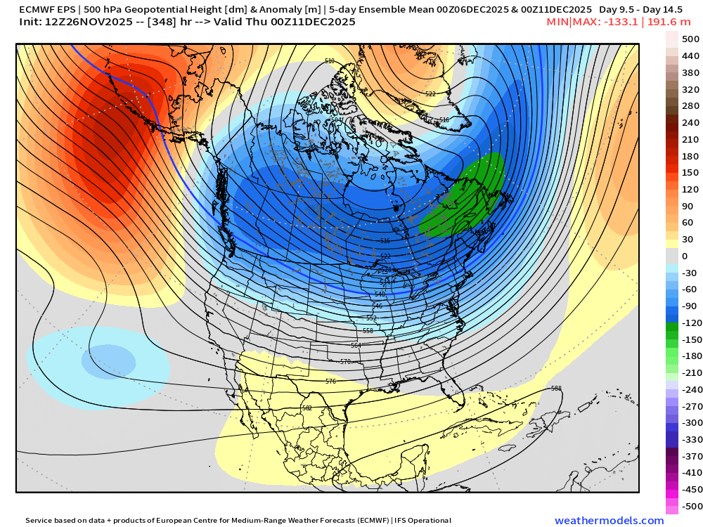
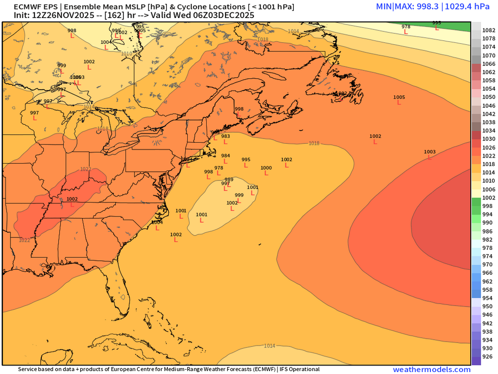
EPS likes 12/6 for another threat. Then when you loop the individual member plot beyond 12/6, it's kind of like buckshot from 12/8-12/11 which is the end of the run...that tells me its pretty active if sub-1004 lows are appearing that frequently on the ensemble plot. Hopefully that NAO depiction is real....it's the type of orientation we want too....the retrograding Scandinavian ridge instead of some ugly thing from the Azors....that type of -PNA/-NAO look I've mentioned in the past can be pretty prolific here.
-
Not very good low level moisture either which is what you want for over achieving WINDEX events.
-
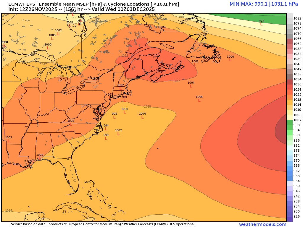
Beyond that 12/2 threat which is pretty precarious as it is....the pattern looks about as favorable as you can get it considering we're firmly in a La Nina/-PDO regime this season....note the NAO ridging that has retrograded into Greenland from Scandavia....this is what Scott and I were talking about when we wanted to see it come back a couple days ago. It's been showing up again and it's gotten a bit stronger the last 2 runs of the EPS, so hopefully it's not fake. It makes the pattern a lot better when you have even just some weak ridging up there. This is a 5 day mean .
-
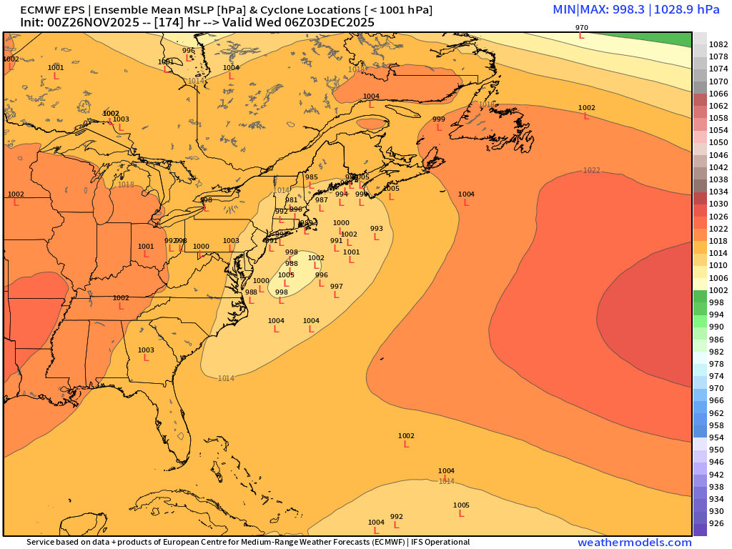
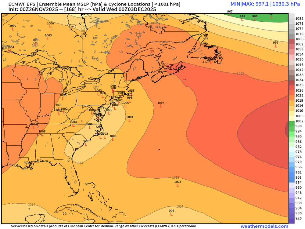
EPS not quite as good as 00z, but this is workable at D7.
-
Euro still has the system and H5 doesn’t look terrible. Not in a bad spot right now.
-
November 2025 general discussions and probable topic derailings ...
ORH_wxman replied to Typhoon Tip's topic in New England
Parakeets and flamingos today. Proba the last of it for a while until Christmas Eve. -
Not the worst spot for the GEFS to be at D6-7


-
LOL at the end of that run trying to form a Hudson Bay block....that would probably produce all sorts of craziness. That's actually how Dec 19-20, 1995 happened.
-
GFS still has 12/2 which is good. GGEM has it but really weak sauce.
-
This type of miller A evolution is probably decent for us if it holds like that. It’s kind of a slower developing system so it’s not like you are going to see it blowing it’s wad down in VA or the Carolinas. Trough stays positively tilted for a while which prevents occlusion too early. This is why I previously mentioned that it’s probably a good thing that the southern stream drags a little. If it didn’t, we’d rip this like due north into BGM or ALB or something.
-
We just don’t know?
-
Yeah the main show looks mostly on Tuesday as presently modeled. But this is kind of a delicate look with the timing of the southern energy. We’re gonna want this to hold serve for a couple more days before confidence increases a lot. The good news is even if that threat craps out, it looks good for additional threats behind it. Overnight longer range guidance has become a little more aggressive in retrograding the Scandinavian ridging into northern Greenland which in conjunction with a bit more amped WPO ridge, is producing a colder look into mid-December.
-
There’s some decent energy rounding the base of the longwave trough after it moves east a bit so we get this brief window for a more coastal system. I think most subsequent threats beyond that are likely to be SWFEs. Previously for 12/2-12/3, the southern stream energy was hanging back in the southwest while northern stream moved over us…then, when the southern stream ejected a day or two later (say getting us by 12/5ish…which is why we were saying post-12/3 looked decent), it would push a SWFE up into the cold that was established ahead of it by the northern stream…but it’s not evolving like that now…instead, they are almost moving together so we get this threat to potentially materialize on 12/2…southern stream still lags a bit which is a good thing because it allows the baroclinic zone to set up offshore. But it’s still close enough that it can produce a coastal on some of these runs.
-
EPS looks pretty decent for a week out. I like seeing those gulf lows a bit offshore at this point. We know how those can trend.

-
Yeah could be old school pond skating by 12/15 if some of these runs are correct.
-
Worst cutter I’ve ever had. Even dendrite got wiped clean after having feet on the ground and his area is CAD-central. It was like a southerly mild gale all the up to Quebec City. My previous worst had been 1996. We had so much snow OTG (and dense) from the double barrel storms earlier that month and an epic 60F+ screamer wiped it all out. But 2020 was worse. It was more snow and the melt happened even faster.
-
November 2025 general discussions and probable topic derailings ...
ORH_wxman replied to Typhoon Tip's topic in New England
Y’all can go to the December thread. -
Likely a top 10% skiing December up north. Lots of early cold for snow making and plenty of natural snow chances. EPS coming in colder in that D10-12 timeframe. Trying to amplify that WPO ridging more. That’s a good sign if we can make that a theme going into this month.
-
Euro looking a bit like GFS for 12/2-3
-
Def a lot lore interesting on GFS for 12/2-12/3. Still selling that even for now…early if it happens.
-
November 2025 general discussions and probable topic derailings ...
ORH_wxman replied to Typhoon Tip's topic in New England
Too much absolutism here. We don’t even know how things will look beyond about 12/14….weeklies actually load a bit of a western ridge leading into Xmas week. Don’t know if I buy it, but there’s plenty of ways to snow if we can keep frigid air in Canada close by which looks to be the case at least. Our glory days of December had cutters too in the 2000s…they are likely to happen. -
November 2025 general discussions and probable topic derailings ...
ORH_wxman replied to Typhoon Tip's topic in New England
Kind of wish the -NAO didn’t disappear on us. Guidance had been quite bullish on it for December but now it’s basically gone. Don’t need a Davis strait block but a bit of -NAO would help pin that cold a little further south. As long as we keep good cross polar flow though and that PV anomaly in SE Canada stays strong, we’ll have chances, but there’s def gonna be some risk we mix in a cutter. -
November 2025 general discussions and probable topic derailings ...
ORH_wxman replied to Typhoon Tip's topic in New England
Yeah let’s get the Mohawk back in the avatar and pretend it’s the late 2000s Decembers when SWFEs were a dime a dozen.