ORH_wxman
-
Posts
93,095 -
Joined
-
Last visited
Content Type
Profiles
Blogs
Forums
American Weather
Media Demo
Store
Gallery
Everything posted by ORH_wxman
-
Wasn’t that long ago that 60” was a crap season IMBY. How the mighty have fallen.
-
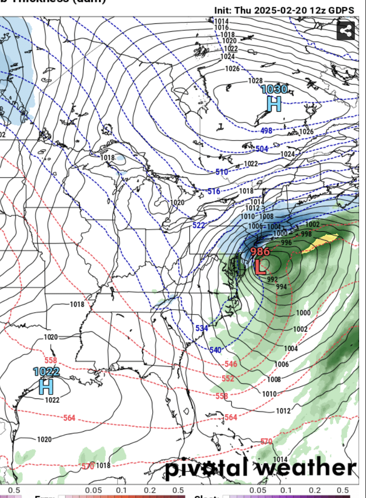
Yep just posted above how good it looks out west for once. But we need Quebec to cooperate…the irony is it’s been cooperative a lot of times this winter when out west was not…but now when we really need the PV in Quebec to play ball, it’s wavering on us. The trend has been good the last day or two. If we see another move SE on that PV tonight and tomorrow, then it probably becomes a serious threat…it will be getting inside of D6 by tomorrow too.
-
There’s a lot of synoptically favorable pieces on this setup out west and into the center of the country…the one key aspect that needs locking down is what happens north of us. Right now, that PV entity is a little too far north or west…move it either south or east (or some combo), and then we’re really talking a significant snow threat…it’s been trending southeast a bit so if it does it a little more, we may have something to track. But I wouldn’t get hopes up yet. If it doesn’t, this remains uninteresting.
-
Yeah been mostly true this winter. But in trying to stay objective here, you have a pretty good press from PV in Quebec that’s going to play a role here. Where exactly that PV feature ends up as the Ohio valley shortwave approaches will decide our ptype
-
Yeah the shortwave is attenuating too so it wouldn’t shock me to see further south trends on that. No guarantees of course but one of the themes of some of our underperforming and “SE trend” snow events this year has been attenuating shortwaves upon approach…maybe this one can work in our favor. Might be too much to ask in 2024-25 winter though.
-
Let’s lock in the Canadian.
-
495 event while Scooter gets transparent slush accumulating on the driveway?
-
That one never looked icy, but there’s an outside chance it could end up snowier if things break right. The one beyond 300 hours on the euro in clown range that was previously an ice storm yesterday is now a cutter on the 00z run.
-
2018-2019 winter was huge in NNE too.
-
Yeah it’s kind of funny that once you’re south of DC (and even DC itself has been decent), this winter will have all kinds of historic relevancy. It will be known for record breaking snows and some record breaking cold. But up here, it’s just going to be remembered as a big tease. It was “wintry” for long stretches this season with snow OTG and ice choking the rivers and lakes frozen, but we avoided big time arctic cold shots and avoided big snow storms with surgical precision. Maybe we’ll get thrown a bone before the season it out. But getting teased a couple more times would be more fitting of this winter.
-
It’s just been the lack of usual long torchy stretches that have defined many of the past 6-7 winters. This winter almost reminds me of 2000-01 without the monster snowstorms. That winter wasn’t particularly cold at all, but it was almost totally devoid of torches so the snow just slowly piled up over the interior and didn’t melt all winter. March was pretty cold but that was more a function of so much storminess rather than arctic outbreaks ala 2014 or 2015.
-
There’s a good argument that it’s even more pathological behavior than obsessively rooting for snow itself.
-
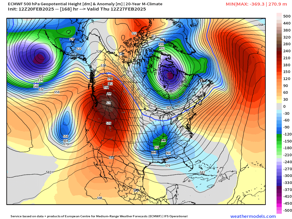
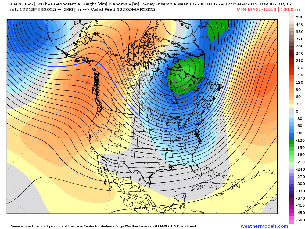
Yeah I don’t know how anyone could say we’re done looking at ensembles. Def doesn’t look like an end to winter. We might even get something next Friday. But even if that fails and ends up warmer, early March looks pretty primed for chances.
-
SSW takes like 3 weeks. But we never achieved an SSW. We achieved a split of the SPV which was actually “bottom-up” from the TPV splitting and not top-down. If it had been from an SSW then we likely would’ve seen another TPV episode of displacement or splitting. But we didn’t. Pattern honestly looks pretty good for additional threats regardless in early March so not sure we want any disruption anyway if you’re looking for more snow events.
-
Was way out in clown range in early March.
-
Done
-
1995 had a biggie on the last day of February. Close enough. Massive ice storm hit NY state in March 1991.
-
Euro finally gives Kevin his catastrophic ice storm in clown range. Let’s do it.
-
Let’s make a run at early March 2007 temps with that PV. We can cheer on a Carolinas/VA snow event.
-
I have about 7.5-8" so the satellite-derived one isn't far that off here, but its def slightly high overall which isn't a surprise because of the water content. The pack in ORH was about 11-12" on winter hill. I think I have about 3 inches of water in the pack...it's ridiculous. I should cut a biscuit and melt it and see what it actually is.
-
New England Winter 2024-25 Bantering, Whining, and Sobbing Thread
ORH_wxman replied to klw's topic in New England
The landing doesn’t look egregiously hard…plane def got put down quickly at the end but it doesn’t seem like it should break off the landing gear like that. Guess we’ll find out more when they review the black boxes for sink rate at the end and hopefully they are able to recover some key landing gear pieces. Wouldn’t surprise me if the gear was faulty. -

-
They aren’t less accurate. We’ve just gotten spoiled at their accuracy increase in the last 15 years. We’ve tracked a lot of storms from over a week out that didn’t waiver too hard…that was almost unheard of in the 2005-2010 years. This particular storm never looked good for us once we got inside of 6 days…if it was 2008 instead of 2025, we would’ve never even really given it a second thought other than clown range fodder…but the increase in accuracy of the models in the last decade-plus has conditioned us to take a D6-7 threat somewhat seriously. So it actually produces some feeling of disappointment or being deceived by guidance when the rug is pulled at 132 hours instead of just laughing it off as clown range.
-
Late February is definitely a weak spot on storm climo. ORH has daily records for snowfall in the single digits for the last few days of February. I always found that fascinating since early March has had so many blockbusters. It’s even somewhat weak going back to about 2/20ish…you really only have 2 or 3 biggies over the record during that 8-9 day period…the biggest being the famous Feb ‘69 100 hour storm.
-
Yeah the fact that Reggie and Icon didn’t seem interested prettt much discredits the NAM solution. Even the 3k was kind of skeptical of the 12k solution.