ORH_wxman
-
Posts
93,095 -
Joined
-
Last visited
Content Type
Profiles
Blogs
Forums
American Weather
Media Demo
Store
Gallery
Everything posted by ORH_wxman
-
Yeah the west slope gets probably on averages a solid 8-10” less per year than equivalent elevation on the east slope of ORH hills. The events you clean up really good in are those westerly component flow events at the sfc. They just aren’t super common. The SWFEs are always fun for most since they remove a lot of the orographic effects and it’s usually just latitude/longitude.
-
SNE will clean up again next week and then when everyone is ready to wishcast napes and DSDs, NNE will get a random 30”+ bomb in the second half of March.
-
If you have a very windy storm like this one and you measure downwind from a roof, you definitely can get inflated totals. These are always so hard to get measurements in. You are essentially reporting a measurement with a legit 10% error bar.
-
Clipper Fires In Wednesday Feb 25 Disco/ Obs
ORH_wxman replied to Damage In Tolland's topic in New England
These events are typically garbage east of the spine of ORH hills. Prob C-1” here…maybe 2” if lucky. -
"Don’t do it" 2026 Blizzard obs, updates and pictures.
ORH_wxman replied to Ginx snewx's topic in New England
Yeah the day before I thought it was fine. Maybe in the finals hours leading into the event I would’ve gone a little more conservative on the northern parts, but overall it was a tough forecast. You can’t kick yourself too much when it trends like 75-100 miles SE in the final 6-10 hours. -
"Don’t do it" 2026 Blizzard obs, updates and pictures.
ORH_wxman replied to Ginx snewx's topic in New England
Prob would’ve been closer to 43-45” or so in clearing because once you are getting 15”+ totals in a 6 hour period like they were, the compaction is already getting baked in to an extent. Also, the snow there wasn’t particularly fluffy for a chunk of the storm. I feel like the biggest discrepancies happen in less windy storms with excellent snow growth and middle type totals. Like that 10-20” range over 18 hours. Or…say you get a very long duration event like ‘78 or Feb ‘69…then you can start adding up those small differences every 6 hours. -
"Don’t do it" 2026 Blizzard obs, updates and pictures.
ORH_wxman replied to Ginx snewx's topic in New England
I’m not sure how you could discredit the 40”+ totals near Fall River. It’s an impossible task anyway and additionally, they were probably in the best stuff longer than TF Green airport was. -
2018-19 was a very good winter in NNE. It was ok here but nothing special. Kind of an inverse of this season where most of SNE (outside of far northern MA) is going to put up a very good grade while most of NNE will be ok but nothing special. Still some time to change it I guess if March does something crazy. That 2018-19 winter did have a pretty signature arctic out real though in January unlike this winter. ORH had a high of 1F I remember, which was the lowest max since 1994 when they also had a high of 1F.
-
"Don’t do it" 2026 Blizzard obs, updates and pictures.
ORH_wxman replied to Ginx snewx's topic in New England
Hillary Andrews just deleted her account -
"Don’t do it" 2026 Blizzard obs, updates and pictures.
ORH_wxman replied to Ginx snewx's topic in New England
Northwest Providence was prob just outside the meat of that band. Difference between getting 1-2" per hour for many hours in a row verses like 3-4" per hour. That can quickly add up to a 10-15" difference. -
Lets trend Tuesday into a beefy cold SWFE....that will make the public go haywire.
-
I'm totally selling friday outside of maybe a weak scrape. We focus on next week for anything bigger.
-
Friday feels like a whiff. Do any OP models even have it as a hit now?
-
Clipper Fires In Wednesday Feb 25 Disco/ Obs
ORH_wxman replied to Damage In Tolland's topic in New England
Post clipper squalls on the 3k.... -
“Cory’s in NYC! Let’s HECS!” Feb. 22-24 Disco
ORH_wxman replied to TheSnowman's topic in New England
Of course he is....there's an unwritten bond between all weather and snow weenies. -
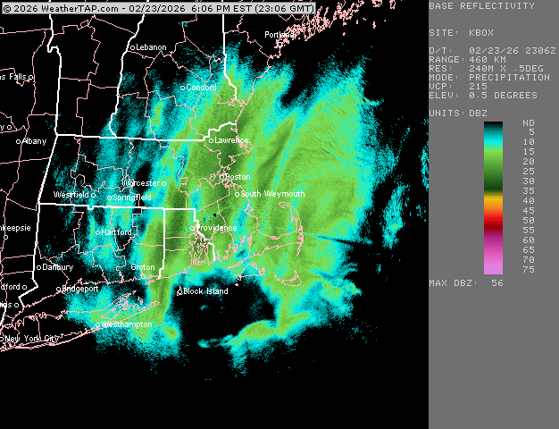
PVD is showing 35.5" for 2/23 and 6.7" for 2/22. That's 42.2" for those counting at home. I'm not sure if this is correct yet, but thats what the two daily CLI summaries show right now. edit: I'm an idiot, that was monthly total on 2/22....yeah they are still 37,9 as CLI on 2/22 was 2.4
-
"Don’t do it" 2026 Blizzard obs, updates and pictures.
ORH_wxman replied to Ginx snewx's topic in New England
Yo, Midlo in the house....thanks man. My front yard looks like yours usually does now. -
I mean, there' always way for torches to fail here in this time of year, even if it "verifies" And by "verifies", i mean it actually ends up AN, but the pretty colors at 850 and 500 are way underpeforming at the sfc with CAD systems or light onshore flow. A 60F torching cutter turns into a cold 37F rain or even ice/rain.
-
Not sure why the BOS and ORH totals are wrong there, but BOS is over 60" now and ORH is actually 75.4" and not 77.5"
-
"Don’t do it" 2026 Blizzard obs, updates and pictures.
ORH_wxman replied to Ginx snewx's topic in New England
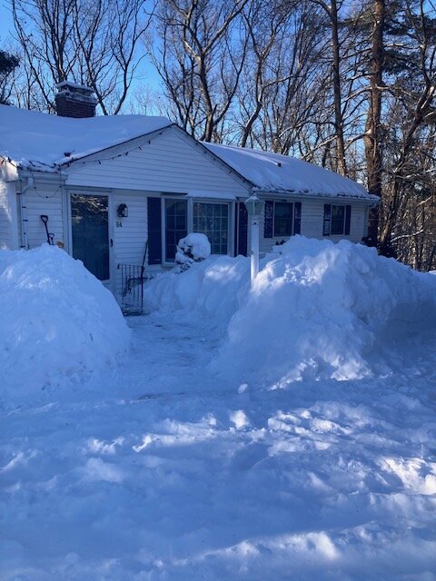
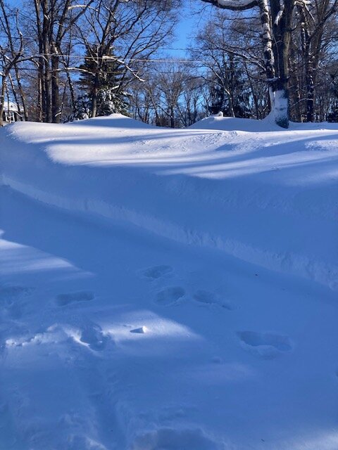
A few pics. I’m posting the pic I took Sunday morning too. The “before” pic for comparison.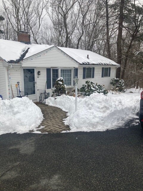
-
Call it 19.5” in Holliston
-
"Don’t do it" 2026 Blizzard obs, updates and pictures.
ORH_wxman replied to Ginx snewx's topic in New England
That is epic for Fall River. I was wondering what they got down there. They were in the meat of that 40+ dbz band for as long as anyone. I think it’s probably real…or at worst, within the margin of error measuring this. -
"Don’t do it" 2026 Blizzard obs, updates and pictures.
ORH_wxman replied to Ginx snewx's topic in New England
ORH was also the previous record 33.0” in the 3/31-4/1 ‘97 storm and then 32.9” in the Dec 1992 storm before that. Ironically, I think the previous 14 years, the record holder was PVD again with that 28.6 in 1978. -
"Don’t do it" 2026 Blizzard obs, updates and pictures.
ORH_wxman replied to Ginx snewx's topic in New England
I def thought you might get deformed like Mar 2018 when this was shifting a bit east. But luck of the draw sometimes in strong coastals. Too bad the ULL didn’t stay further west under E LI because then nobody gets slotted or exhaust in SNE. -
"Don’t do it" 2026 Blizzard obs, updates and pictures.
ORH_wxman replied to Ginx snewx's topic in New England
Might pick up there in a few. That band is trying to backbuild a bit into Middlesex county