ORH_wxman
-
Posts
93,099 -
Joined
-
Last visited
Content Type
Profiles
Blogs
Forums
American Weather
Media Demo
Store
Gallery
Everything posted by ORH_wxman
-
Everything is too far west initially…almost looks like some of the garbage western trough patterns we had in recent winters…but I think once we get to the 16th or so we’ll have a few chances as the mean trough moves pretty close to us over the apps.
-
Feels like we slightly underperformed on lift/QPF too. Ended up closer to the more flaccid guidance. Those big solutions down here were ripping an inch and quarter of QPF easy in the pike corridor
-
Might happen for Wednesday. But we should torch for a few days before that.
-
Yep. Decent western ridge progged and some good cold to tap into. Hopefully the synoptic pieces line up as we get closer but the longwave pattern will want to give us a couple chances I’d think. 11-15 is actually reasonably snowy. Esp northern half of New England but I think everyone is fair game.
-
Everything iced. A little sleet here but not much.
-
There should be a few hour period of pretty damned strong lift ahead of that sharp height fall/dryslot. That should start reaching us within an hour or so…sooner out west. If Ray’s area can flip to snow pretty quickly during that, then def several inches is on the table. But if it stays very mixy…
-
Lower atmosphere is prob loaded with salt nuclei with this ENE flow. When you have a higher concentration, they can form ice crystals as warm as like -4C or -5C. So that crappy needles are prob a sign it’s right near the threshold in the cold layer.
-
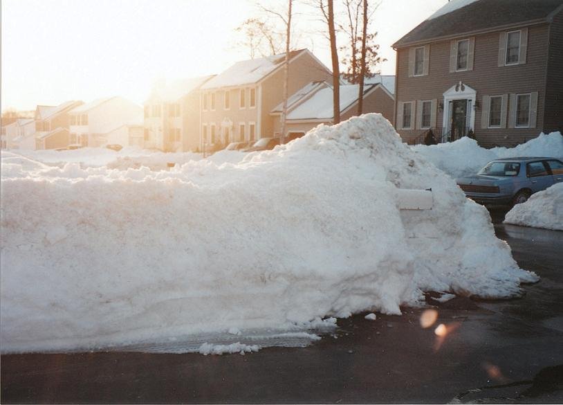
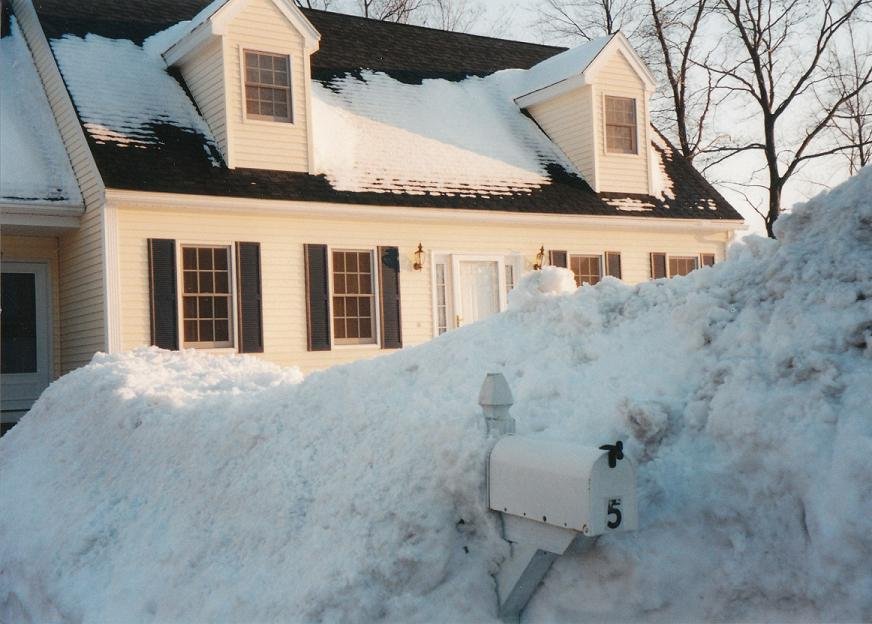
Yeah imagine that falling on top of the snow in those pics I posted above. It’s why I still have March 2001 as the king of snow pack in all my winters. Feb 2015 was super impressive but it did not have the amount of water the 2001 pack had at its peak.
-
He also authored the original Wintertime Instability Index (WINDEX) paper. Dude’s def a winter weather legend in the field
-
You guys are prob good for at least solid advisory. If you can flip to 100% snow sooner rather than later, could be a higher surprise.
-
These two pictures were taken March 8, 2001 in ORH. There would actually be another storm the next day that dumped 6-10” from interior MA up into CNE. Coastal MA got some too but more on the lower end.
-
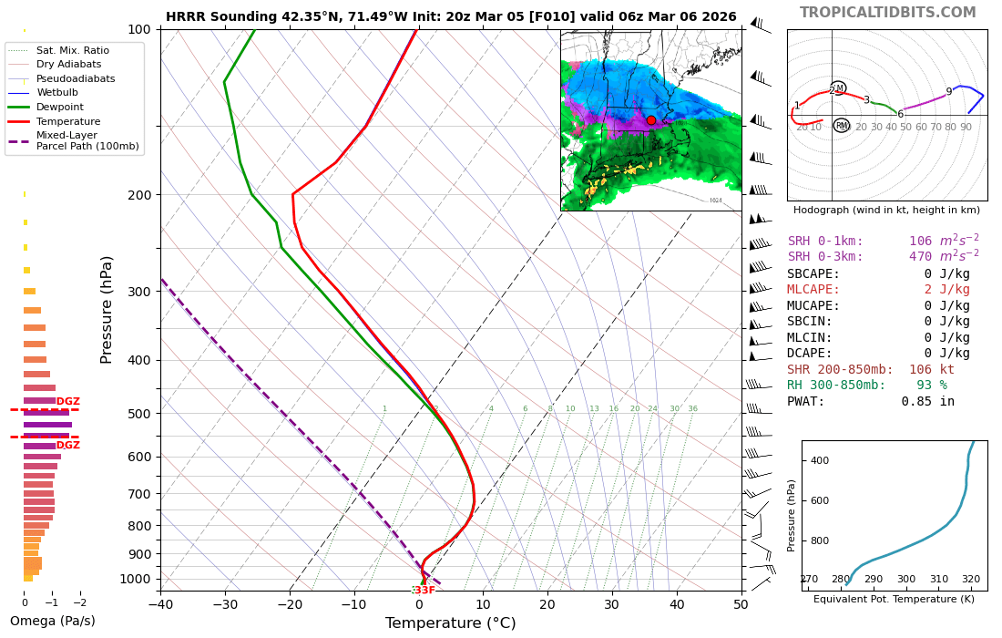
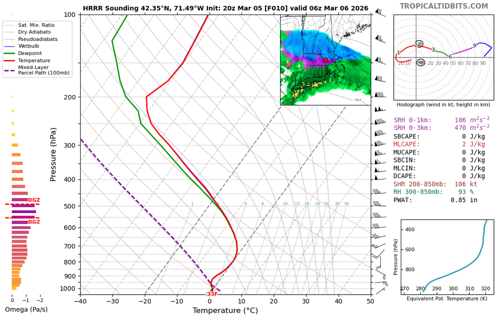
33F and rain here. If we can get pingers by 03-04z, prob a decent sign we can flip to snow by 06z assuming we’re ripping big omega. But otherwise I’m keeping expectations pretty low here. I’d feel pretty decent NE of about BED for at least advisory stuff.
-
Near midnight and just beyond is when you see the sounding try and go nuts....if we get big omega, then we can prob flip to paste....otherwise lot of sleet and mangled flakes probably....but you can see here what the HRRR is tryong to do (other guidance was similar)....you start blasting the DGZ with deep lift, then you can really latently cool the column efficiently. And almost every single sounding has that warm layer really thin too. So you know this could be a rate-dependent type of system.
-
FIT or ORH? Typically ORH is gonna have lower dewpoints because of the elevation difference. But if you’re a rad pit, you may start off the day artificially low because of extra moisture that was lost from the atmosphere when you condensed frost or dew.
-
KFIT is prob kind of fake because they radiated so well earlier. ORH has been rotting at 29F dewpoint for hours....briefly spiked to 31F when rain moved in, but fell again when it tapered.
-
Nothing scream busting colder right now. Not overly impressed with the dewpoints yet in SE NH/E MA. PSM is 29F dew. Need that at least 4-5F lower. Or at the very least, 2-3F colder with a corresponding SFC temp drop so that it’s the same difference for wetbulb…if we’re trying to bust colder. It’s fairly close to most guidance.
-
These usually “bust” on the warmer side when you are waiting for cold air to advect in…sometimes they work out. But I’d want to see an acceleration of the better airmass and more importantly, I want to see big omega tonight.
-
Need to see dews dropping well into the 20s I think by mid-late afternoon to feel more frozen with this one. This feels like one of those events where a ton of QPF is wasted on 33-36F rain. But we’ll see.
-
Lol. His jackpot fetish has only increased as he’s gotten older. Didn’t mellow at all. Pretty on he’ll be doing 5 page write ups on a 1-2” event if Boston and ORH will miss it.
-
Difference is lift between the NAM and those shorter term mesos. Those shorter mesos just go bonkers. NAM is more subdued. Lots of 33F rain on NAM.
-
12z RAP might have even been more violent than the HRRR. It has like 8-10” of spackle even on kuchera maps. It’s an isothermal blue bomb for pike region over to Scooter and BOS and north to Ray.
-
Let’s get a March 24, 1993 mini blue bomb at Logan (over 8” of pure spackle on a weak but juicy system running into a Quebec high with marginal antecedent airmass)
-
Ray will get 4-5” while everyone else gets slop or nothing and he will declare it the best event since 1/7/24.
-
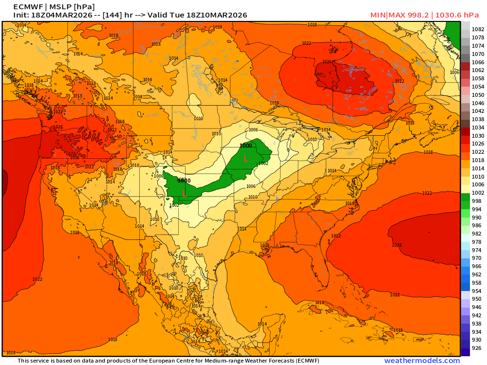
18z euro starting to show the dendrite-drift on the high middle of next week. That’s gonna be my new term for Quebec highs trying to nose down and ruin torches. It’s the high pressure version of the messenger shuffle. @dendrite gets the honors since his area is usually first on tap to get screwed by these.
-
Yeah that def helps too. We'll see what the real dews do to it early next week.