ORH_wxman
-
Posts
93,092 -
Joined
-
Last visited
Content Type
Profiles
Blogs
Forums
American Weather
Media Demo
Store
Gallery
Everything posted by ORH_wxman
-
That airmass is legit, if the system taps into that on the backside, then it's going to snow right to the coast. It's a needle-threader for sure though....you're trying to time the shortwave so that the CCB is over the region while the high is building in. Most guidance actually shows this so there's decent agreement. It's just a precarious setup and they could lose it.
-
The last one got way too political. We tried it for months and it eventually got worse and worse. People couldn’t behave themselves so it stays off the wx side. Ya’ll can go discuss it on Ampol or somewhere else. I’m not a fan of censorship but this is a wx forum and we’ve always been strict about keeping politics off the wx side. The covid thread was an exception...and then it ultimately proved why we keep politics out of here.
-
Yeah I missed this one. But your idea reminds me of the days we did radio shows. We usually only do them for KU type threats for the mid-Atlantic but we could totally utilize zoom for some bigger New England-centric threats.
-
This thread is becoming too covid-centric. We got rid of the other one for a reason.
-
Ray try this. I think it has ukmet on there (MetOffice) https://climate.copernicus.eu/charts/c3s_seasonal/ There’s an “NCEP” option. Not sure if that is the CFS or not. Probably is since I’m not aware of another domestic seasonal model.
-
Yeah...great find by radarman and interesting paper but it was definitely 1994. I do remember that 1999 event...starting off absolutely frigid and then going to 50+. Almost like a different January 1994 event where we were snowing and like 7F and then 10 hours later we were 50-55F with steaming snow banks before the front put the deep freeze back on everyone later that night. I actually think you’ve mentioned that storm before Tip when you were up at Lowell.
-
There was actually a paper published on the January ‘94 storm that dropped the OES with sleet. It was back when Weymouth Naval Air Station still existed with obs (code KNZW I recall)...they were reporting heavy snow with sleet and under quarter mile vis. Almost the snow production was between 975-875 millibars with a max cold layer around -13C...with a thin elevated warm layer around 750mb. Wish I could find the paper. Perfect heavy snow dendrites from OES while the synoptic stuff was producing pingers. Hilarious.
-
The largest percent positive spike has occurred amongst the age 5-17 group in the past few weeks. So I wouldn’t be surprised if CFR is even a little lower than the summer peak....hopefully that is the case.
-
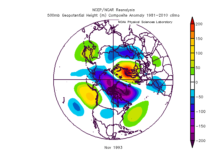
There’s always exceptions to the rule but you’d rather not have one. Btw i wouldn’t classify Nov 1993 as a pig month. Def huge +AO but it had ridging approaching the EPO region.
-
Nov 2010 def had a November pig, it was kind of an exception to the Nov pig rule. But I do recall vividly that the vortex was forecasted to break down mid-month...it ended up lasting closer to thanksgiving but it did break down before the month was over, so it never looked very bleak.
-
Alyeska ski area averages like 700” but they aren’t nearly in the highest spot or probably even the best spot. I’d guess there’s probably locations there that average well over 1000 inches per year but there’s nobody to record it. You’d probably die from avalanches being near those spots, lol.
-
Where the hell is that? Maybe the Chugash mountains or something in Alaska?
-
You don’t want the AK pig in mid to late November. It’s ok if it’s in the first half of month and transient. If that GEFS pattern is what we have through late month, then it’s very worrisome. Judah is right though that the EPS isn’t all that bad. It actually has a -WPO pattern.
-
https://apps.ecmwf.int/webapps/opencharts/products/seasonal_system5_nino_plumes?base_time=202010010000&nino_area=NINO3-4
-
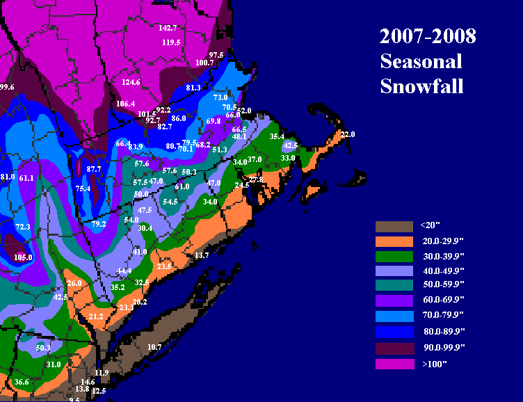
52.0" to be exact. I think they are officially listed as 51.2" because somehow the 0.8" from 12/31/07 never made it into the database even though it was on the PNS, lol. But I have the correct 52.0 on my map.
-
You could argue Logan was low relative to its surroundngs.
-
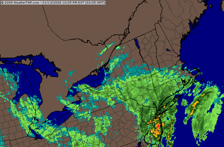
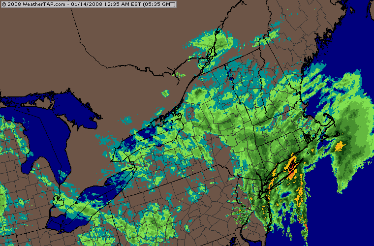
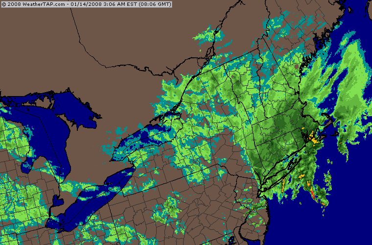
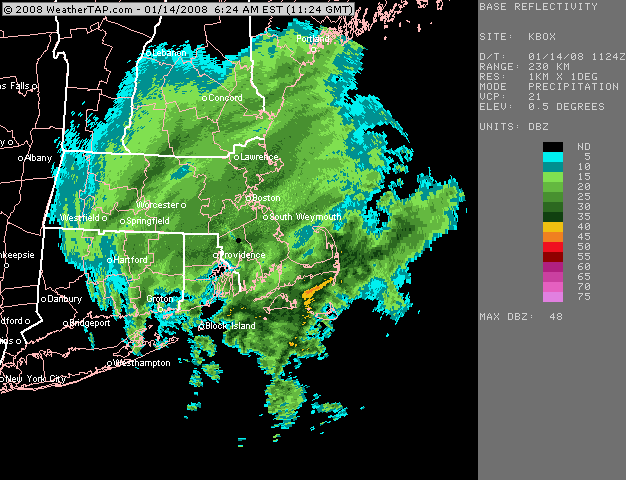
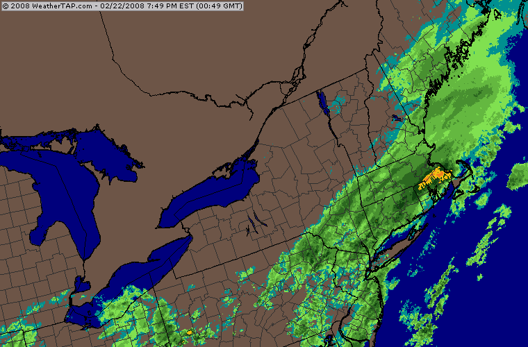
This was actually a nice storm in January 2008....infamous for the huge bust in NYC (almost all rain there when they had a warning out for like 5-8"). I think BOS had about 7-8" and I had just under 10". It was my largest storm of the season....barely (12/16/07, 12/13/07, and 2/22/08 were like all an inch less)
-
Chane the values in the "override default contour interval" feature near the bottom before submitting the map. Go like "interval = 0.1" "High 1.5" :Low = -1.5"
-
Do you have a telescope available to view that gif?
-
Yep. Overrunning storm that basically lasted all afternoon and evening. Mixing tickled the pike late in the event, never quite got IMBY.
-
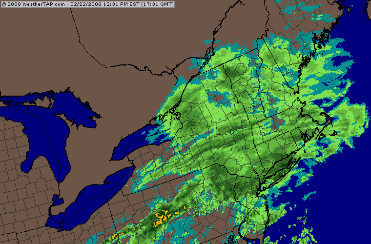
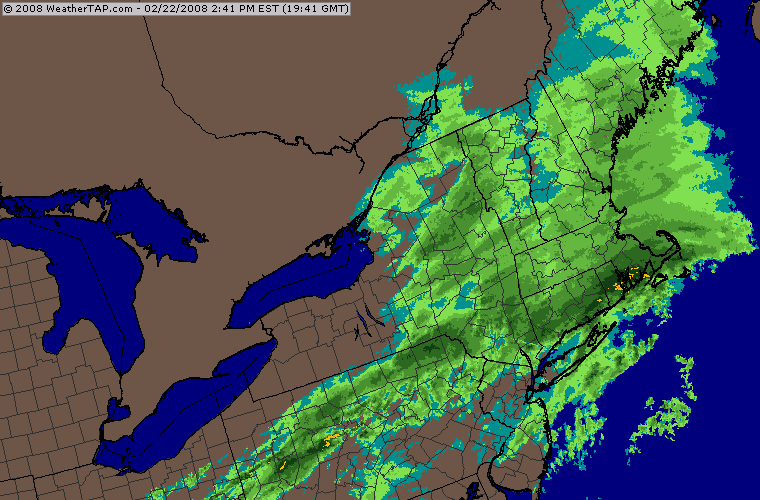
Feb '08 was pretty good in the interior....had the snow to big icing event on 2/13/08 (this event narrowly missed a Dec '08 type disaster), then the big 2/22 storm that got most of SNE with 7-12" and then two more events....a nice overperformer front ender on 2/26 and then the clipper redeveloper 2/29-3/1.
-
Yeah we were prob slightly unlucky in Feb considering it was cold and pretty active still. But then again we kept pulling triple 7s on the slot machine in January so I guess we were due for a few misses. One of these years we’ll keep it going. Might be a one in 200 year type lucky break, but eventually there will be the January 2011 pattern (or feb 2015) and instead of things basically ending, you continue it on a less obscene scale but it drives the winter into unprecedented territory. I sort of picture something like ‘95-‘96 without the 2nd half of January utter meltdown pattern or maybe 2010-2011 where we get a little luckier in February/March. Something like that. Hopefully we’re alive to see it, lol.
-
It was better the further north you went. Pike region got hit pretty hard during the Groundhog Day two part system. There was a big thaw mid-month that lasted 3-4 days for the meat of it. Knocked my pack down from like 38” to 20” or so. There was a pretty good snow to ice back to snow event for CNE on 2/25/11...really hammered over from Brian’s area to southern ME (apparently only moderately fringed tamarack’s area per an earlier post about this storm) where they had a foot-plus in some spots....down here we had like 1-2” on the front end and then had another 1-2” when it flipped back. A lot of ZR in between in ORH. I don’t think there was much down in your hood. Maybe an inch or so but you prob had some ZR for a while. Then on 2/27 there was a clipper/redeveloper that was really good for the MA/NH border region. We had like 3” in ORH but Megan was living up in North Chelmsford at the time and I was actually up there for that event and measured 7.5”. The jackpot was just a tad further north than that from Ray’s current area into SE NH where they had 9” I believe. Big positive bust system up in that general area...a really heavy band blew up as the system was exiting stage-right. Then yet another system the next day started...big icing over interior ORH area we had like 3/8th of ice and started getting a few power issues before it ended as 33-34 rain. Winter basically ended after that around here....there was the really tight gradient WNW to ESE frontal system that hammered powderfreak’s area on 3/6-7 I believe but virtually nowhere else in New England got in on that....the rare almost-exclusively longitude system We did get s few cameo events such as around the equinox and then again on 3/31-4/1 but by then the pack had mostly been eradicated and the winter feel was gone.
-
72/56 here....pretty much perfect weather.
-
Here's some winters that were pretty good La Ninas with a bit of strength to them (i.e. I didn't include weak Ninas like 1995-1996 and 2000-2001 that behaved almost like El Ninos)