ORH_wxman
-
Posts
93,098 -
Joined
-
Last visited
Content Type
Profiles
Blogs
Forums
American Weather
Media Demo
Store
Gallery
Everything posted by ORH_wxman
-
That algorithm looks pretty optimistic based on what I saw....but it would definitely still be solid advisory snows over the interior....maybe NW Berks and S VT/Monads could squeeze 6.
-
06z Euro looks like it's going to be flatter than 00z.
-
The sheared monster coming to get us last night. This fast flow is relentless. Definitely a flatter theme in the overnight runs. Hopefully we can slow things down just a smidge on today’s runs. That said, obviously still a decent shot at first flakes and maybe some accumulation.
-
Yeah it’s going to move. But it will max out too and then start weakening. Where the convergence of it maxing out and residence time is the highest is where someone will get smoked. Like for example, most everyone is getting moderate rain and then as that vort swings up the precip starts intensifying and it flips to snow at Mitch’s in S VT....and the band really starts going to town big time...then it maxes out over SW NH and N MA and then collapses SE slowly weakening (but still intense). In that scenario we’d prob see the highest snows from near Mitch (who was snow the longest but maybe not quite where the band reached peak intensity) to SW NH (which was snow the 2nd longest but saw the most intense period of the band)...and then the amounts would be less to the southeast but still mostly everyone sees at least some period of snow.
-
Yeah that has the look of cold rain to hearing pellets hammering the skylights and windshields for maybe an hour or two and then flashing to heavy snow. Some impressive dynamics on this whole setup. As long as the southern vort can maintain its integrity long enough, I think someone will see a really intense period of snow...location TBD as we get closer.
-
Yeah the NAM was about to hammer interior SNE if we had another frame. That cold was collapsing SE really quickly with a shortwave that was still pretty deep.
-
I found one of the old threads. Kind of funny seeing some of the old handles that are preserved in quotes (CT_blizz, cpick79, Hubbdave, capecodweather.net, wxwatcher91)....of course many of us have not changed handles. https://www.americanwx.com/bb/topic/28304-second-winter-storm-threat-oct-2930/page/25/
-
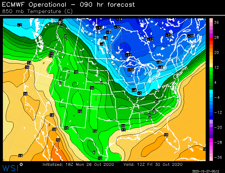
Yeah we had 2-3” from that in ORH. It was crazy enough that we were getting measurable in October nevermind a historic blockbuster brewing right behind it. Yeah it might have even been a little colder than that. I feel like it was -6 at 900....and like -7 or -8 at 850 in the CCB. The only thing it didn’t really have was a legit high placement....it had a high but it was actually kind of retreating a bit toward Nova Scotia as the event unfolded. That’s probably what cost places like BOS (or at least immediate suburbs) from getting crushed.
-
2011 was different in that the antecedent airmass was very cold. It wasn’t a system that was “waiting for the cold air” like this one is. It did trend a bit colder as we got closer though. Euro latched on first about 4 days out or so (maybe 4.5-5...can’t quite recall), and then other guidance started falling in line. Ironically we were kind of distracted by a rain to snow event on 10/27 preceding it. So we were trying to forecast for that while wondering if 10/29-30 was actually going to happen as some guidance showed or if we would see a last minute Lucy....given how historic it was, it was easy to be skeptical until quite close.
-
18z euro was definitely a little more crunched S than the 12z. But I wish we could see another panel or two. That was probably going to hammer CNE and SNE those next couple frames.
-
It rips for a few hours and its cold....I don't think you have to downplay the ratios too hard in the CCB part of the storm....the front side up north (esp lower elevations)? Yeah, I think you'd be a little more conservative, but once everything is collapsing SE, it gets really cold quickly. It's just a matter now if we keep the look or if this trends further north and tries to run into the Hudson Valley....or gets sheared apart on futures. Either could happen.
-
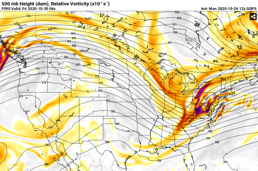
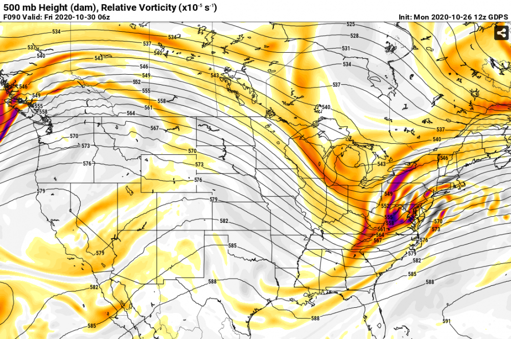
It's all about the southern stream phase and how far west it happens...there's competing forces here. You have the big southern stream bowling ball that wants to send this thing into Ottawa if it fully phases, however, the screaming PJ to the north is ripping in and trying to squeeze or pinch the bowling ball as it gains latitude and that acts to shove the storm east. So if the bowling ball stays unphased longer, you get a more sheared storm and further SE. You get an earlier and more fully phased solution (like today;s Euro/Ukmet), then it's going to try and hug the coast for a while before it finally gets crunched E.
-
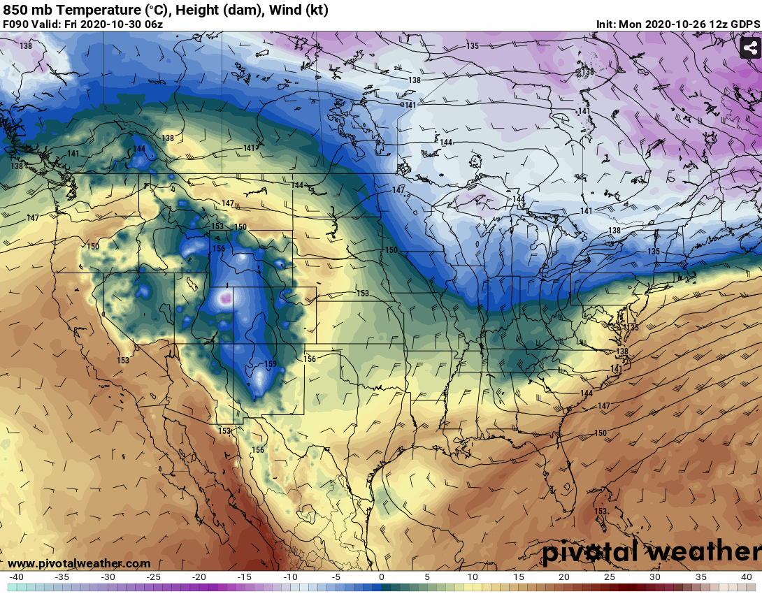
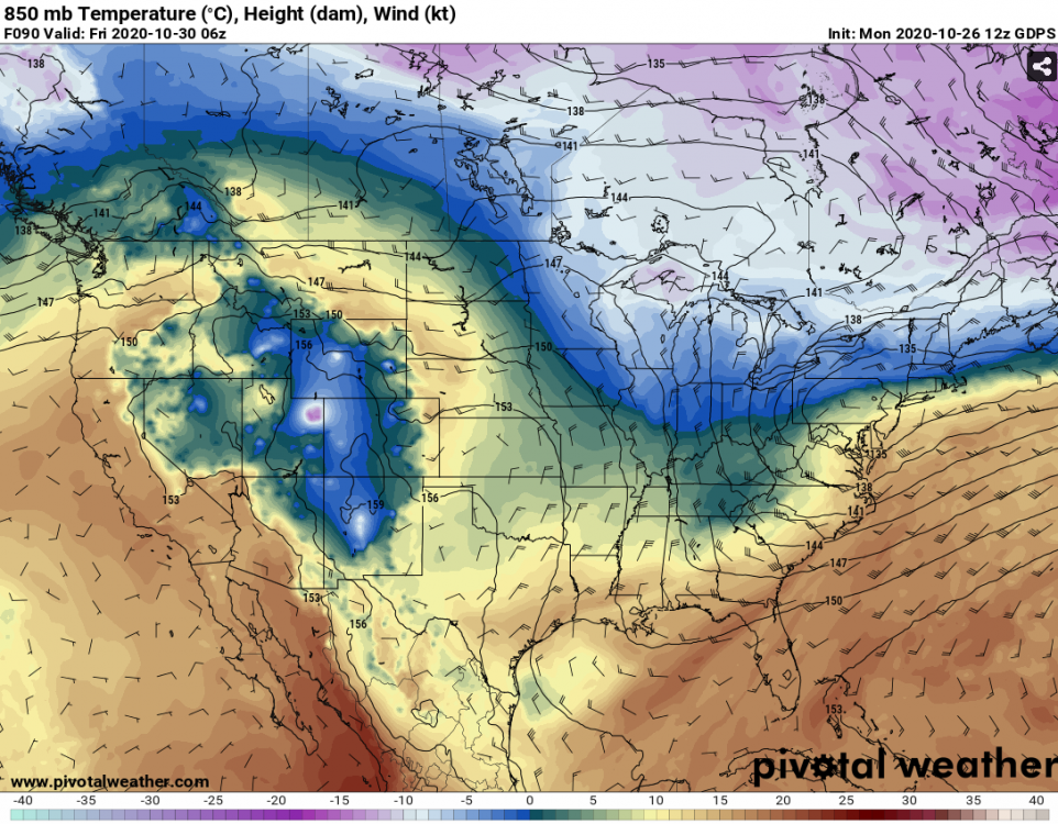
That would be absolutely nightmare driving if it plays out like that...it's showing basically a flash freeze late afternoon/early evening across a chunk of the interior. Not typically what you see in October snow systems. It's a very cold airmass getting drawn in.
-
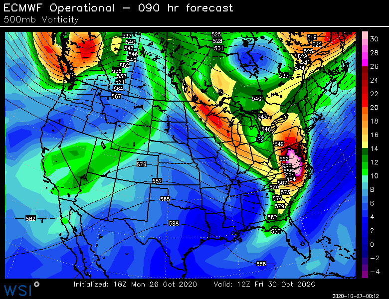
Southern bowling ball phases in this run. By far the biggest difference from the 00z run.
-
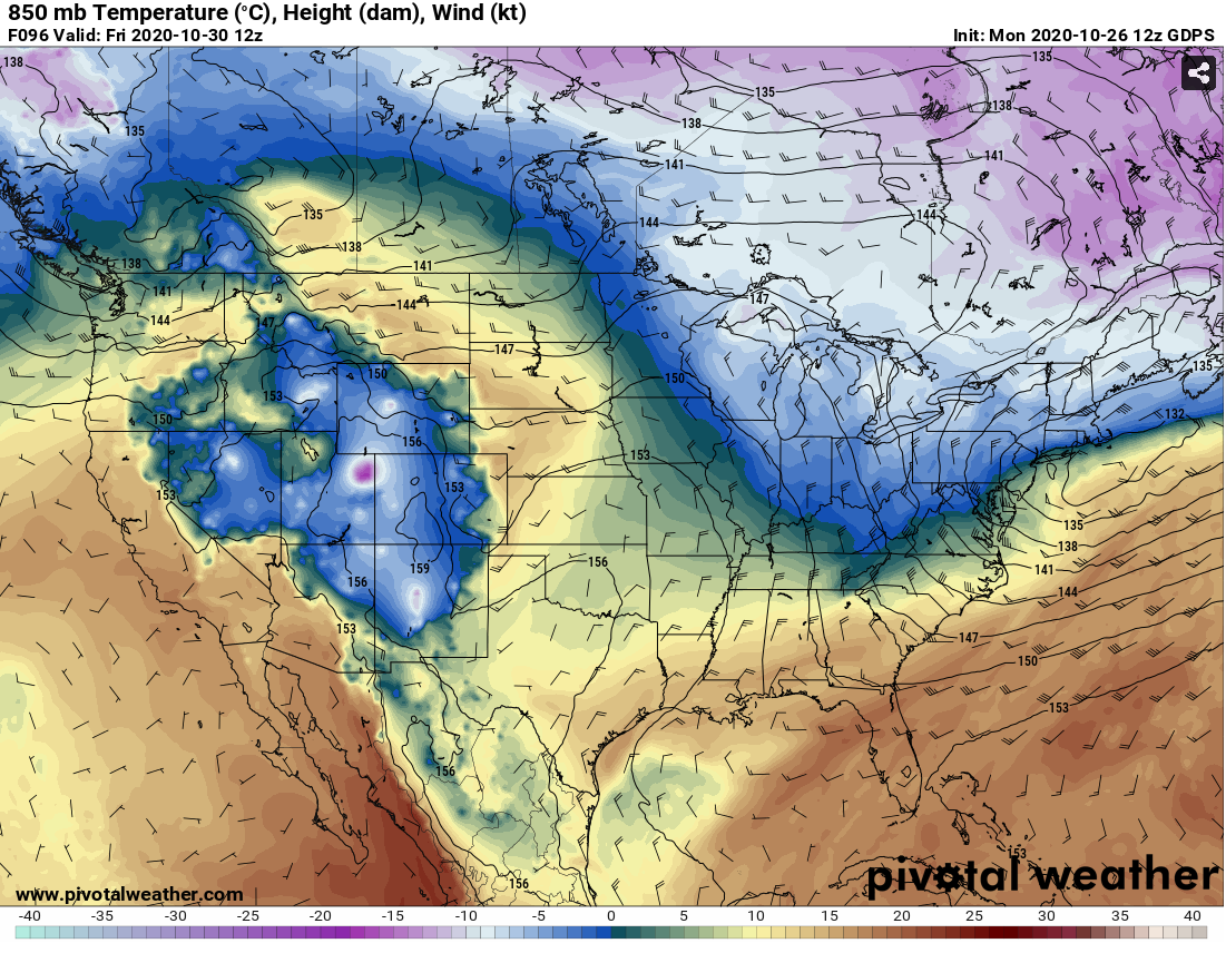
-5 to -6C at 925mb wrapping into it.
-
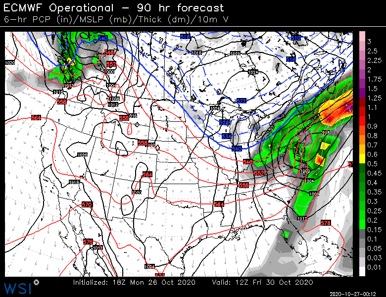
Nice little CCB over eastern SNE Friday afternoon/evening.
-
Euro looks like it's gonna be pretty good for some areas...esp CNE but also into SNE.
-
Yeah that ukie solution is a little far northwest for SNE to maximize the snowfall but it gets squeezed so quickly, that it would still give a flash over and prob 1-2" for a chunk of SNE....while CNE/NNE would get warning snows out of that. You get a compromise solution of the Ukie and some of the further SE guidance, that's when the alarm bells would go off for SNE peeps.
-
It's quickly collapsing SE at that point...prob changes most of SNE over to snow quickly after that frame. The detailed maps are not out yet on pivotal though so I can't see it. But even a pretty far west amped solution is going to produce some snow. We want the happy medium of amped, but not obscenely tucked west, which I'm less afraid of in this super fast pattern than I am of something hideously sheered.
-
The strong anti-cyclonic flow over Maine and Quebec at H85 is a good giveaway too. That is just rushing into the deepening ML center on that type of setup. Here's the next frame in case you didn't already get the idea

-
GGEM kind of shows what I was just discussing with Ginx and Scott. You can see the southern stream bowling ball gets more involved with the northenr stream here and by the time that happens, take a look a H85....it's over...the outcome is cemented from that point. Everything collapses SE. Thats close to what you are looking for in a snowier solution. Maybe even more wrapped up as it goes south of us, but that is the idea.
-
I thought rain was implied given the month....but yeah. Rain is still the most likely ptype of many.
-
Yeah it feels counter-intuitive at first glance to want the ULL more amped for better snow in SNE, but I think that would produce more snow ultimately than a flatter solution. Yeah, it might initially shove the precip pretty far N and NW, but as it gets squeezed, you'd see the R/S line collapse very quickly SE and probably produce a really intense area of frontogenesis over SNE before it exits.
-
I changed the title of the thread to make it a little clearer....I moved Ray's joke to the subtitle, lol.