

ORH_wxman
-
Posts
93,092 -
Joined
-
Last visited
Content Type
Profiles
Blogs
Forums
American Weather
Media Demo
Store
Gallery
Everything posted by ORH_wxman
-
First Legit Storm Potential of the Season Upon Us
ORH_wxman replied to 40/70 Benchmark's topic in New England
NAM looks exceptional in the soundings too during the evening hours for a time. Lots of cross hair sig showing up. Hopefully it’s correct. -
First Legit Storm Potential of the Season Upon Us
ORH_wxman replied to 40/70 Benchmark's topic in New England
One thing that might help is that when looking at these soundings, the DGZ is pretty deep. So if we can get any type of decent deep layer lift, I’m guessing ratios will be pretty good even for a “wet snow”….its pretty cold off the deck during the meat of it so even 31-32F at the sfc could produce what I call “dry wet snow”. It’s kind of superficially wet maybe on the very sfc but it still is dry enough to hold lots of air if the snow growth is good. Just something to keep an eye on. If we see a lot of 5-6” amounts where 0.3-0.4” of QPF is being progged, it might not be a QPF bust, but better-than-expected ratios. Now if we just get lighter crap, none of this will even be relevant. -
First Legit Storm Potential of the Season Upon Us
ORH_wxman replied to 40/70 Benchmark's topic in New England
I’m actually liking my spot tomorrow. Far enough inland with a little elevation to avoid major temp issues, but far enough east to hopefully get some good bands even on an 18z scenario. I still think SE MA is going to rip for a while. Might have to wait until 00z for the real goods but they should arrive. I think the midday/PM stuff could be kind of banded/spotty…if it isn’t, that’s a positive sign. -
First Legit Storm Potential of the Season Upon Us
ORH_wxman replied to 40/70 Benchmark's topic in New England
I’d like to see that early band showing up more robustly on other guidance. Some guidance shows legit snow in that while others are kind of insignificant (like maybe an inch or so). -
First Legit Storm Potential of the Season Upon Us
ORH_wxman replied to 40/70 Benchmark's topic in New England
Hard to see 8” back into the deeper interior. -
First Legit Storm Potential of the Season Upon Us
ORH_wxman replied to 40/70 Benchmark's topic in New England
Yeah today was just a disaster on model guidance. Euro prob did the best but even it didn’t quite capture it accurately. -
First Legit Storm Potential of the Season Upon Us
ORH_wxman replied to 40/70 Benchmark's topic in New England
Yeah this is why we don’t really over analyze the NAM. 3k isn’t even that similar to 12k this run. -
First Legit Storm Potential of the Season Upon Us
ORH_wxman replied to 40/70 Benchmark's topic in New England
It’s the NAM though, so whatever. No use in over analyzing it. -
First Legit Storm Potential of the Season Upon Us
ORH_wxman replied to 40/70 Benchmark's topic in New England
Maybe a bit east, but yes, decent overlap. -
First Legit Storm Potential of the Season Upon Us
ORH_wxman replied to 40/70 Benchmark's topic in New England
Best dynamics this run are actually from about 495 back through Kevin’s area and CT -
First Legit Storm Potential of the Season Upon Us
ORH_wxman replied to 40/70 Benchmark's topic in New England
One mild negative this run is the vort doesn’t look like it has as good of a “curl” to it by 21h -
First Legit Storm Potential of the Season Upon Us
ORH_wxman replied to 40/70 Benchmark's topic in New England
NAM looks a little more amped through 15h…we’ll see how it handles as it climbs latitude. -
Another Coating of Snow Saturday - "It's all we Got"
ORH_wxman replied to Sey-Mour Snow's topic in New England
Coming down moderate here now. Finally starting to stick to everything except pavement. 33F. -
First Legit Storm Potential of the Season Upon Us
ORH_wxman replied to 40/70 Benchmark's topic in New England
All about rates for eastern zones imho….hard to have major ptype issues if 925 is like -3 with good rates. If the rates are crappy, it will be white rain. But as I always say, “if the rates are so crappy you can’t snow in that thermal profile, you weren’t missing out on much anyway.” -
First Legit Storm Potential of the Season Upon Us
ORH_wxman replied to 40/70 Benchmark's topic in New England
Regular EPS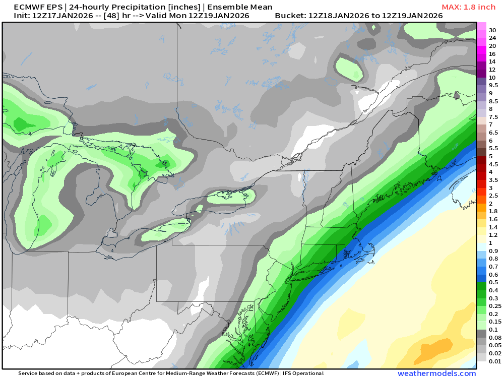
-
Another Coating of Snow Saturday - "It's all we Got"
ORH_wxman replied to Sey-Mour Snow's topic in New England
Actually snowing good here now. Just got in on the edge. We’ll see for how long. Temp 33.5.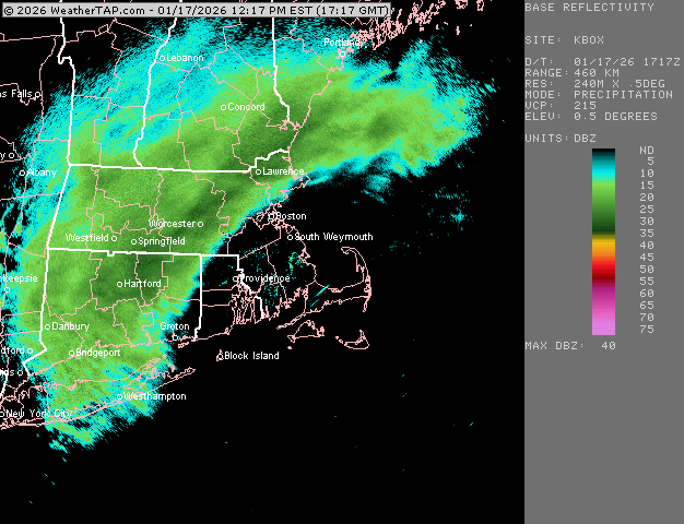
-
Another Coating of Snow Saturday - "It's all we Got"
ORH_wxman replied to Sey-Mour Snow's topic in New England
Yeah both were consistently SE of other guidance on this. -
Another Coating of Snow Saturday - "It's all we Got"
ORH_wxman replied to Sey-Mour Snow's topic in New England
That band is crushing ORH KORH 171754Z 21008KT 1/4SM R11/2200V2800FT +SN FZFG VV009 M01/M02 A2994 RMK AO2 SLP153 P0003 60005 T10111017 10006 21039 58033
-
Another Coating of Snow Saturday - "It's all we Got"
ORH_wxman replied to Sey-Mour Snow's topic in New England
Kind of weird being on the line here. We get occasional weenie flakes and then it will stop and then start again. Temp has been around 33-34F but literally like 5-7 miles S or E is 37-40F…it’s like we’re getting a bit of evap cooling being on the edge -
First Legit Storm Potential of the Season Upon Us
ORH_wxman replied to 40/70 Benchmark's topic in New England
That’s pretty good poundtown near BOS down through south shore tomorrow evening and early overnight hours on the euro. -
First Legit Storm Potential of the Season Upon Us
ORH_wxman replied to 40/70 Benchmark's topic in New England
Might lose a couple tenths of QPF down near buzzards bay. But if euro is right you’d still be near warning criteria despite that. -
First Legit Storm Potential of the Season Upon Us
ORH_wxman replied to 40/70 Benchmark's topic in New England
12z euro just for tomorrows storm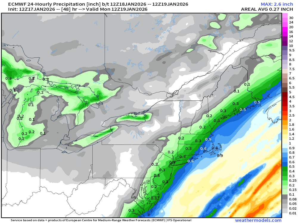
-
First Legit Storm Potential of the Season Upon Us
ORH_wxman replied to 40/70 Benchmark's topic in New England
That’s a big hit for SE Ma on euro. Even up into BOS. -
First Legit Storm Potential of the Season Upon Us
ORH_wxman replied to 40/70 Benchmark's topic in New England
Canadian ticked west. Really nice look for SE MA on that run. -
First Legit Storm Potential of the Season Upon Us
ORH_wxman replied to 40/70 Benchmark's topic in New England
OP GFs sfc kind of escaped east that run so it wasn’t quite as juiced with the main stuff. Still has moderate stuff pretty far west though. It actually might have trended slightly better over interior while being a bit worse for coast.


