

ORH_wxman
-
Posts
93,099 -
Joined
-
Last visited
Content Type
Profiles
Blogs
Forums
American Weather
Media Demo
Store
Gallery
Everything posted by ORH_wxman
-
January 2026 regional war/obs/disco thread
ORH_wxman replied to Baroclinic Zone's topic in New England
You were Arnold in Commando a few years ago and now you’re the dude from Indiana Jones and the last Crusade who drinks from the wrong cup. -
January 2026 regional war/obs/disco thread
ORH_wxman replied to Baroclinic Zone's topic in New England
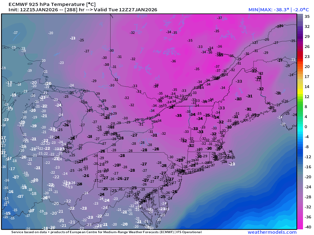
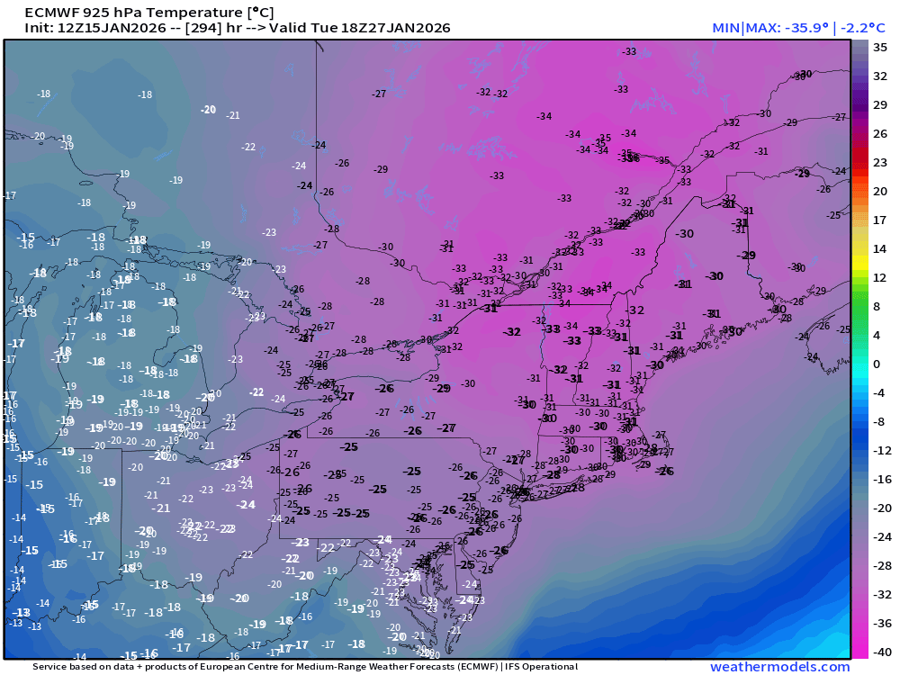
Ok these are the cold events that @dendrite and I like to track. Cold worth tracking. Pure clown range fantasy but it’s so anomalous its worth posting…. Not sure I’ve seen -30C at 925 over such a large area. This would be almost perfect too if the timing happened this way because you wouldn’t get the cheap midnight high. Real push arrives between 00z-06z and its so strong that we get like a Xmas 1980 type daytime with highs near -10F even over interior SNE.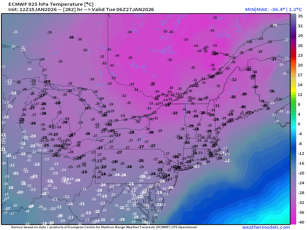
-
First Legit Storm Potential of the Season Upon Us
ORH_wxman replied to 40/70 Benchmark's topic in New England
EPS actually looked slightly better vs 00z…that isn’t saying much though. But it gets 1-2” to south shore area and Cape. -
January 2026 regional war/obs/disco thread
ORH_wxman replied to Baroclinic Zone's topic in New England
The irony in the 1/18 disaster….model guidance today got a lot more interesting for next week and weekend. Some legit hits showing up. Ensembles have always liked this period so let’s see if they bag a win. -
January 2026 regional war/obs/disco thread
ORH_wxman replied to Baroclinic Zone's topic in New England
@CoastalWx
-
First Legit Storm Potential of the Season Upon Us
ORH_wxman replied to 40/70 Benchmark's topic in New England
Lots of “interest” these days but can never bring home the bacon. Whether it’s the models or FSG, same idea. -
Another Coating of Snow Saturday - "It's all we Got"
ORH_wxman replied to Sey-Mour Snow's topic in New England
NAM looks totally different and starts it predawn. Most of the euro stuff is afternoon/early evening. Most other guidance is closer to euro on evolution of Saturday stuff. -
First Legit Storm Potential of the Season Upon Us
ORH_wxman replied to 40/70 Benchmark's topic in New England
Hopefully they can get another 6”+ event like last year. -
Another Coating of Snow Saturday - "It's all we Got"
ORH_wxman replied to Sey-Mour Snow's topic in New England
Yeah could start at 33-35ish but 925 is like -2 or -3 so should easily wetbulb/latently cool down to 31-32. I’m a little skeptical of sfc warming from like 28 to 35 though over interior in a few hours….esp high terrain. -
Another Coating of Snow Saturday - "It's all we Got"
ORH_wxman replied to Sey-Mour Snow's topic in New England
Yeah that’s the best chance of getting everything covered before the cold shot early next week. Esp for central and western areas. Eastern areas will have more trouble Saturday and they have a better chance of getting a few inches from the actual coastal. -
First Legit Storm Potential of the Season Upon Us
ORH_wxman replied to 40/70 Benchmark's topic in New England
Watch 00z trend hard back west again. -
Another Coating of Snow Saturday - "It's all we Got"
ORH_wxman replied to Sey-Mour Snow's topic in New England
Euro actually has a nice slug of snow Saturday PM from Kevin up through ORH county. Could be a solid 2-3 -
First Legit Storm Potential of the Season Upon Us
ORH_wxman replied to 40/70 Benchmark's topic in New England
OP euro looks like a clean whiff. Might be the furthest east now. -
First Legit Storm Potential of the Season Upon Us
ORH_wxman replied to 40/70 Benchmark's topic in New England
Yep. One of them is gonna crash and burn and it’s prob gonna be the AI guidance. But no guarantees. We wait and see. -
First Legit Storm Potential of the Season Upon Us
ORH_wxman replied to 40/70 Benchmark's topic in New England
In a synoptic threat 3-4 days out, it’s going to be extremely tough to defeat the Euro/GFS and their ensembles if they are in close agreement. I’d want to see the 12z euro improve at least…otherwise I’d be more inclined to punt the AIs. However, a 70/30 compromise in favor of the OP models will still produce some accumulating snow in eastern zones, but obviously not a big event. -
January 2026 regional war/obs/disco thread
ORH_wxman replied to Baroclinic Zone's topic in New England
Gonna be a couple threats next week…Friday looking like the most threatening, but perhaps a smaller one on Wednesday. Most are focused on the 1/18 failure, but next week may fly under the radar until then. -
First Legit Storm Potential of the Season Upon Us
ORH_wxman replied to 40/70 Benchmark's topic in New England
GEFS are pretty damned close to EPS now as well. A little better than the OP runs but not by a lot. Maybe an inch or two for eastern areas. -
First Legit Storm Potential of the Season Upon Us
ORH_wxman replied to 40/70 Benchmark's topic in New England
Wagons east on the Ukie. Whiff. -
First Legit Storm Potential of the Season Upon Us
ORH_wxman replied to 40/70 Benchmark's topic in New England
You could argue it never bought into the deep ULL traveling south of us for 1/15 when the other guidance was trying to show it. It turned out more correct. But that wasn’t nearly as high stakes imho than this one. This one is definitely more of a fundamental difference. I’m skeptical AI will score the coup but this is a good test. -
First Legit Storm Potential of the Season Upon Us
ORH_wxman replied to 40/70 Benchmark's topic in New England
Yeah that’s actually a tick worse than 06z. No difference to us, but at least 06z was getting outer Cape and islands into decent stuff. -
First Legit Storm Potential of the Season Upon Us
ORH_wxman replied to 40/70 Benchmark's topic in New England
This is actually the best test yet because we have definitive camps for the AI models on both GFS and Euro. Big difference in the same direction between OP runs and the skynet runs. -
First Legit Storm Potential of the Season Upon Us
ORH_wxman replied to 40/70 Benchmark's topic in New England
Pretty much on par with 06z on OP run. Skynet actually trended better. -
First Legit Storm Potential of the Season Upon Us
ORH_wxman replied to 40/70 Benchmark's topic in New England
OP run looks like ka-ka through 72 -
First Legit Storm Potential of the Season Upon Us
ORH_wxman replied to 40/70 Benchmark's topic in New England
If we can get that MN kicker s/w to keep digging west, that is going to help. You want to do anything to help the southern vort gain latitude without sacrificing too much eastward longitude. NAM is digging it further west which was good…not that the NAM is good, but that’s what you’ll want to see on other model guidance. -
First Legit Storm Potential of the Season Upon Us
ORH_wxman replied to 40/70 Benchmark's topic in New England
Prob a scraper for SE areas. Not relevant though at this time range.


