

ORH_wxman
-
Posts
93,099 -
Joined
-
Last visited
Content Type
Profiles
Blogs
Forums
American Weather
Media Demo
Store
Gallery
Everything posted by ORH_wxman
-
Another Coating of Snow Saturday - "It's all we Got"
ORH_wxman replied to Sey-Mour Snow's topic in New England
Kind of weird being on the line here. We get occasional weenie flakes and then it will stop and then start again. Temp has been around 33-34F but literally like 5-7 miles S or E is 37-40F…it’s like we’re getting a bit of evap cooling being on the edge -
First Legit Storm Potential of the Season Upon Us
ORH_wxman replied to 40/70 Benchmark's topic in New England
That’s pretty good poundtown near BOS down through south shore tomorrow evening and early overnight hours on the euro. -
First Legit Storm Potential of the Season Upon Us
ORH_wxman replied to 40/70 Benchmark's topic in New England
Might lose a couple tenths of QPF down near buzzards bay. But if euro is right you’d still be near warning criteria despite that. -
First Legit Storm Potential of the Season Upon Us
ORH_wxman replied to 40/70 Benchmark's topic in New England
12z euro just for tomorrows storm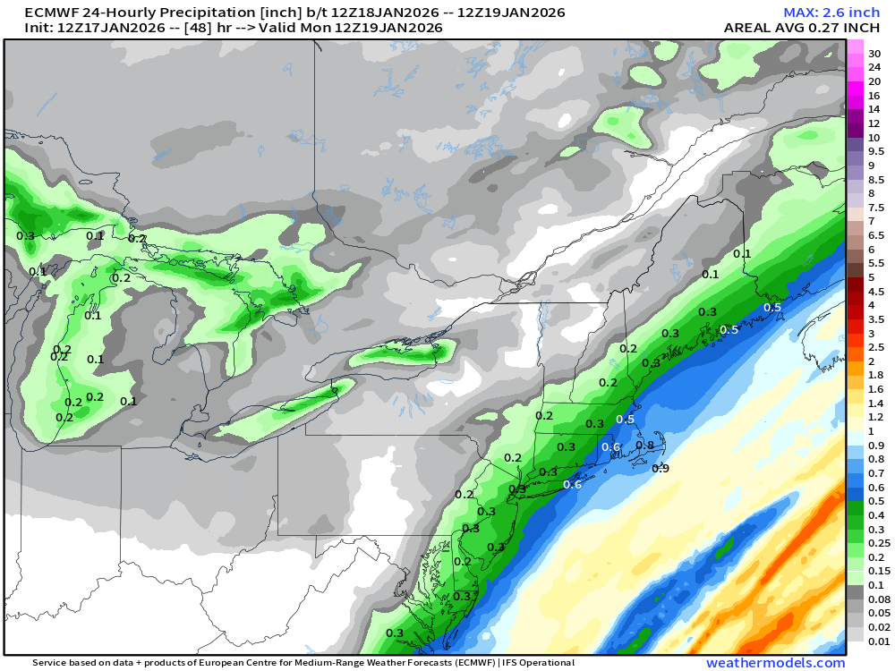
-
First Legit Storm Potential of the Season Upon Us
ORH_wxman replied to 40/70 Benchmark's topic in New England
That’s a big hit for SE Ma on euro. Even up into BOS. -
First Legit Storm Potential of the Season Upon Us
ORH_wxman replied to 40/70 Benchmark's topic in New England
Canadian ticked west. Really nice look for SE MA on that run. -
First Legit Storm Potential of the Season Upon Us
ORH_wxman replied to 40/70 Benchmark's topic in New England
OP GFs sfc kind of escaped east that run so it wasn’t quite as juiced with the main stuff. Still has moderate stuff pretty far west though. It actually might have trended slightly better over interior while being a bit worse for coast. -
First Legit Storm Potential of the Season Upon Us
ORH_wxman replied to 40/70 Benchmark's topic in New England
That model was jacking the Berkshires overnight. Pretty useless more than 24h out. Looks like it’s starting to come back to reality. -
First Legit Storm Potential of the Season Upon Us
ORH_wxman replied to 40/70 Benchmark's topic in New England
Has that nice curl to it -
First Legit Storm Potential of the Season Upon Us
ORH_wxman replied to 40/70 Benchmark's topic in New England
Looking a little more amped -
First Legit Storm Potential of the Season Upon Us
ORH_wxman replied to 40/70 Benchmark's topic in New England
Prob borderline warning here. Not buying that much yet but hopefully rest of 12z guidance keeps ticking W -
First Legit Storm Potential of the Season Upon Us
ORH_wxman replied to 40/70 Benchmark's topic in New England
I feel like it overdoes diabatic warming when there’s no obvious high or ageo flow from the north. Esp beyond 24h…euro actually used to to this pretty bad too but now it’s much better than a few years back. -
First Legit Storm Potential of the Season Upon Us
ORH_wxman replied to 40/70 Benchmark's topic in New England
Yeah it’s prob a little on the warm side…just not egregiously so. I’d prob shave a couple degrees off it around here. Euro seemed more realistic. -
First Legit Storm Potential of the Season Upon Us
ORH_wxman replied to 40/70 Benchmark's topic in New England
Yeah I don’t see an issue with this run. All guidance has 32-35 tomorrow during the day until it falls late afternoon. The real snow doesn’t happen until then anyway. There’s some front-running stuff that has been a relatively recent development on most guidance that falls morning/midday but it’s not the main show…at least for eastern areas it isn’t. -
First Legit Storm Potential of the Season Upon Us
ORH_wxman replied to 40/70 Benchmark's topic in New England
Icon was more amped too. -
First Legit Storm Potential of the Season Upon Us
ORH_wxman replied to 40/70 Benchmark's topic in New England
The vort didn’t quite curl like 00z but everything started west so the end result was pretty similar to 00z…it was heftier south of here. Maybe a bit better on south shore as well. -
First Legit Storm Potential of the Season Upon Us
ORH_wxman replied to 40/70 Benchmark's topic in New England
06z NAM is coming in more amped than 00z through 27h -
First Legit Storm Potential of the Season Upon Us
ORH_wxman replied to 40/70 Benchmark's topic in New England
Yeah look at that vortmax. Much better on the 00z run. That’s what we need to watch. If you can allow that to stay more consolidated with a bit of H5 curl, you can escalate things pretty fast. -
First Legit Storm Potential of the Season Upon Us
ORH_wxman replied to 40/70 Benchmark's topic in New England
Man, if we could get a last second trend of trying to curl this vortmax under SNE, we could escalate the totals pretty quick. Only problem with such a fine trigger is it doesn’t take much to make this a whiff in the other direction. -
First Legit Storm Potential of the Season Upon Us
ORH_wxman replied to 40/70 Benchmark's topic in New England
Didn’t you say it was already pretty far NW earlier…must be zonked now -
First Legit Storm Potential of the Season Upon Us
ORH_wxman replied to 40/70 Benchmark's topic in New England
That’s a pretty solid advisory event for eastern third….maybe even flirting with low end warning type stuff in far SE MA -
First Legit Storm Potential of the Season Upon Us
ORH_wxman replied to 40/70 Benchmark's topic in New England
NAM significantly west -
First Legit Storm Potential of the Season Upon Us
ORH_wxman replied to 40/70 Benchmark's topic in New England
Yeah as bad as this stretch has been, I haven’t sniffed futility. ORH hasn’t had a season below 40” during this stretch and even here they’ve all been over 30”. Terrible seasons but just mundanely terrible and wouldn’t be particularly noteworthy if they were surrounded by normal or AN winters….its just the fact we’ve gotten several in a row. -
First Legit Storm Potential of the Season Upon Us
ORH_wxman replied to 40/70 Benchmark's topic in New England
Probably nobody. Though ironically your area is prob the best chance even though you also have the best chance of getting shutout (actually prob just barely to your east has the best shot at getting shutout from both…like Windham county up 495 belt) -
First Legit Storm Potential of the Season Upon Us
ORH_wxman replied to 40/70 Benchmark's topic in New England
Yeh I was gonna respond and forgot…but eerily similar if you just look at relative heights…gotta adjust for era, but those ‘79-80 heights relative to eachother are pretty close to this year so far. Go figure, I used to post that map as an example of a decent winter pattern where we just got boned. Happens again 46 years later. Maybe we’ll break the bad juju with this two week stretch coming up where we’ll have plenty of chances. But if we roll snake eyes during that too….we can throw this winter into the wood chipper. Irredeemable at that point. I’d revert myself to hoping for an exotic HECS in March.

