

ORH_wxman
-
Posts
93,099 -
Joined
-
Last visited
Content Type
Profiles
Blogs
Forums
American Weather
Media Demo
Store
Gallery
Everything posted by ORH_wxman
-
Rise of the Machines: January 18-19 Winter Storm Obs Thread
ORH_wxman replied to WxWatcher007's topic in New England
Growth a little better in that band down here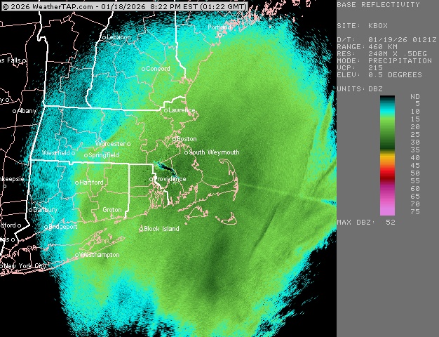
-
Rise of the Machines: January 18-19 Winter Storm Obs Thread
ORH_wxman replied to WxWatcher007's topic in New England
-
Rise of the Machines: January 18-19 Winter Storm Obs Thread
ORH_wxman replied to WxWatcher007's topic in New England
Some good bands getting going over interior
-
Rise of the Machines: January 18-19 Winter Storm Obs Thread
ORH_wxman replied to WxWatcher007's topic in New England
Sneaky decent winter so far on the Cape. -
Rise of the Machines: January 18-19 Winter Storm Obs Thread
ORH_wxman replied to WxWatcher007's topic in New England
Snow growth is still pretty crappy here but it’s like that 1/2 mile fog stuff. It’s dense but piling up. Some darker bands trying to get going…when we’ve occasionally had a little pulse of those, we’ve gotten better growth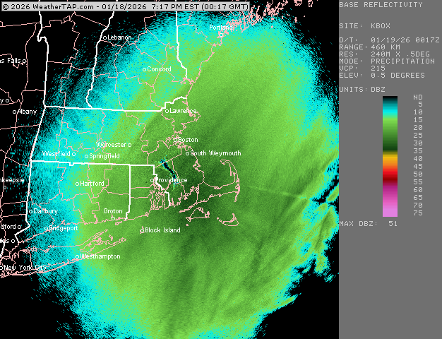
-
Rise of the Machines: January 18-19 Winter Storm Obs Thread
ORH_wxman replied to WxWatcher007's topic in New England
SE MA is cleaning up right now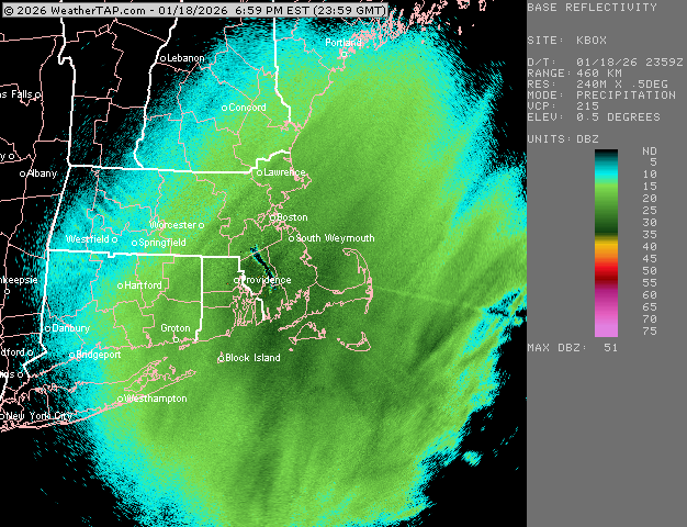
-
Rise of the Machines: January 18-19 Winter Storm Obs Thread
ORH_wxman replied to WxWatcher007's topic in New England
Snow growth def isn’t that good yet. It’s snowing easily moderate and sticking but it’s more like something slightly better than baking powder. But the best progs on soundings were more like 8pm through midnight or so over eastern areas. That’s when the lift got deeper into DGZ, so hopefully we start seeing that. -
Rise of the Machines: January 18-19 Winter Storm Obs Thread
ORH_wxman replied to WxWatcher007's topic in New England
Between now and about 1am is poundtown for eastern areas. Might get some good high ratio fluff after that but the real meat is the next 6-7 hours. -
Rise of the Machines: January 18-19 Winter Storm Obs Thread
ORH_wxman replied to WxWatcher007's topic in New England
Impressive bands starting to develop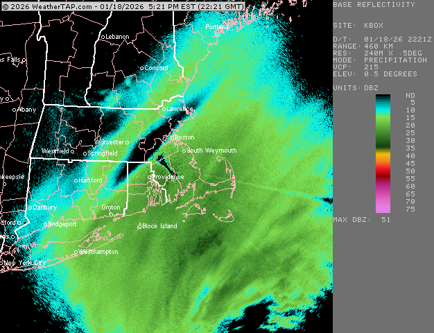
-
Rise of the Machines: January 18-19 Winter Storm Obs Thread
ORH_wxman replied to WxWatcher007's topic in New England
WCB stuff currently south of LI was never gonna hit us anyway with any real force unless maybe clipping the cape. It’s all about the stuff to the west of that blossoming. -
Rise of the Machines: January 18-19 Winter Storm Obs Thread
ORH_wxman replied to WxWatcher007's topic in New England
That’s good stuff too. Not super heavy but prob a much colder BL near the coast by that point with steep lapse rates and decent snow growth with lots of salt nuclei on those IVT lower level lift setups. Kind of thing where you can weasel another 1-2” out of 0.07 QPF or something. -
Rise of the Machines: January 18-19 Winter Storm Obs Thread
ORH_wxman replied to WxWatcher007's topic in New England
You’ll need ratios to get that much. -
January 2026 regional war/obs/disco thread
ORH_wxman replied to Baroclinic Zone's topic in New England
AIs are liking the overrunning system while OPs suppressing it. Let’s see how consistent AI is in the coming few days vs the OPs. Wonder if we see another bias-correction win for the AIs….I had mentioned just a couple posts up how you often see those types of systems come north. I wonder if the AI models already know that from past data and are correcting for it. It will be interesting to track either way. -
Rise of the Machines: January 18-19 Winter Storm Obs Thread
ORH_wxman replied to WxWatcher007's topic in New England
Don’t think the rates are there for a lot of warning amounts. But there will def be some good snow growth I think got a few hours this evening. -
January 2026 regional war/obs/disco thread
ORH_wxman replied to Baroclinic Zone's topic in New England
Always watch massive gulf-infused overrunning setups. They love to come north. So seeing them down south right now at this juncture isn’t the worst thing. There’s clearly a lot of spread anyway…EPS has QPF well into New England on these 24h panels.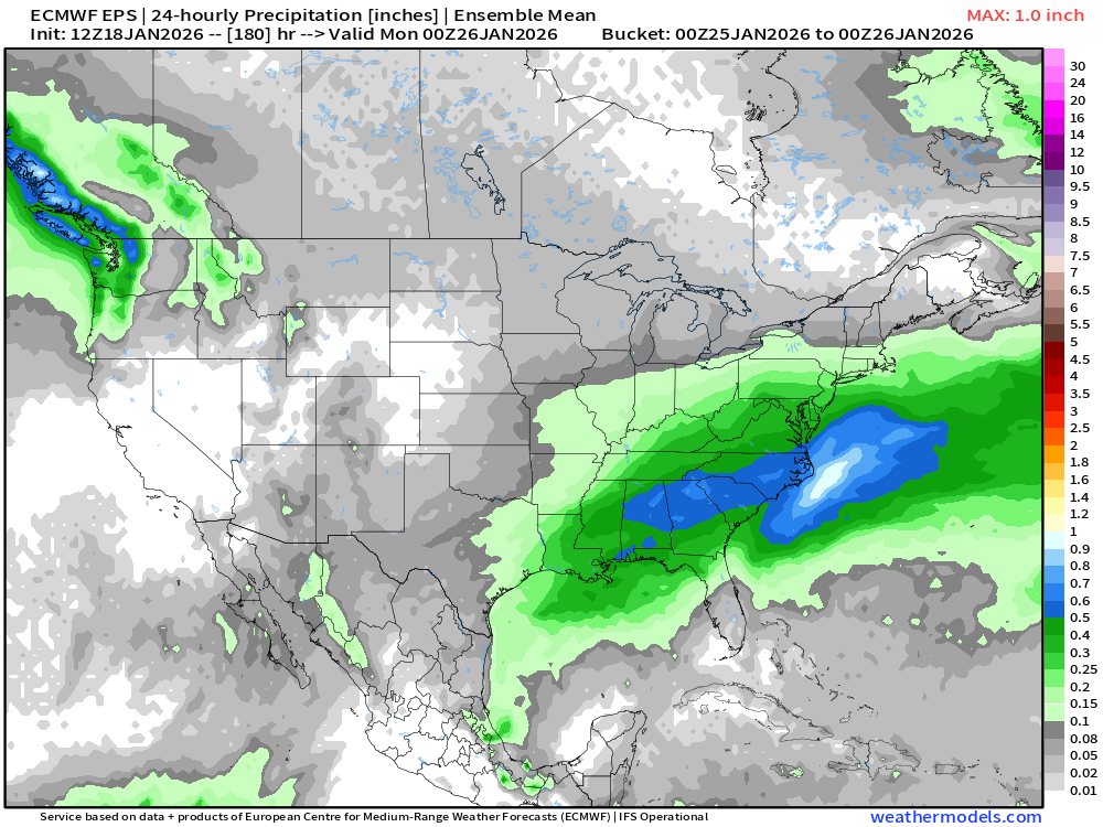
-
First Legit Storm Potential of the Season Upon Us
ORH_wxman replied to 40/70 Benchmark's topic in New England
Fwiw, I think it’s good to talk about it a lot because the more we all recognize and point out where the AIs were successful, then we can start to pick up patterns….maybe they are good in some types of setups and crappier in others relative to the OP guidance. -
First Legit Storm Potential of the Season Upon Us
ORH_wxman replied to 40/70 Benchmark's topic in New England
Yes but we just don’t use it in the shorter term since we have great short term models. If we can rely on AI as a solid tool for medium range, then that has a lot of value. -
Rise of the Machines: January 18-19 Winter Storm Obs Thread
ORH_wxman replied to WxWatcher007's topic in New England
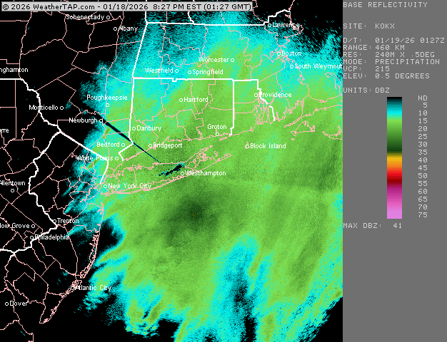
It’s gonna look mostly like crap for a while if guidance is correct. It will start to look better to our south and southwest around mid afternoon….youll see precip start to blossom and expand over NJ and south of LI. -
First Legit Storm Potential of the Season Upon Us
ORH_wxman replied to 40/70 Benchmark's topic in New England
Not very good in short term. It def kicked the operational’s butts though in that D3-5 period. -
Rise of the Machines: January 18-19 Winter Storm Obs Thread
ORH_wxman replied to WxWatcher007's topic in New England
Yeah I think you guys will stack decently between 00z and 06z. Prob will be slow going until then. That’s true for most of us actually. Central’ and western CT folks a little earlier on the meat of the stuff. -
Rise of the Machines: January 18-19 Winter Storm Obs Thread
ORH_wxman replied to WxWatcher007's topic in New England
This is what I was talking about earlier on a lot of these runs this evening. That heavier stuff is slamming the DGZ pretty hard…this is the latest hrrr but NAM has been showing it pretty consistently for several hours….so there could be some pretty efficient QPF to accumulation ratios if that pans out (and as a rule, you can lower that DGZ a little for us in SNE since we tend to have a lot of salt nuclei in the clouds here versus much of the country further away from the ocean)
-
Rise of the Machines: January 18-19 Winter Storm Obs Thread
ORH_wxman replied to WxWatcher007's topic in New England
14z run def looks healthier. Hopefully it’s catching a real trend. -
January 2026 regional war/obs/disco thread
ORH_wxman replied to Baroclinic Zone's topic in New England
Feb 2023 was bare ground. But we had snow pack for Jan 2019, late Dec 2017/early Jan 2018, and Feb 2016. Any other arctic outbreaks since 2016 that I didn’t list were prob pretty meh so they don’t stick out to me. But that Feb ‘23 outbreak was so impressive considering it was bare ground and yet it fell in prestigious company for all time lows at some of the major SNE sites. -
Rise of the Machines: January 18-19 Winter Storm Obs Thread
ORH_wxman replied to WxWatcher007's topic in New England
That band in SE MA is crushing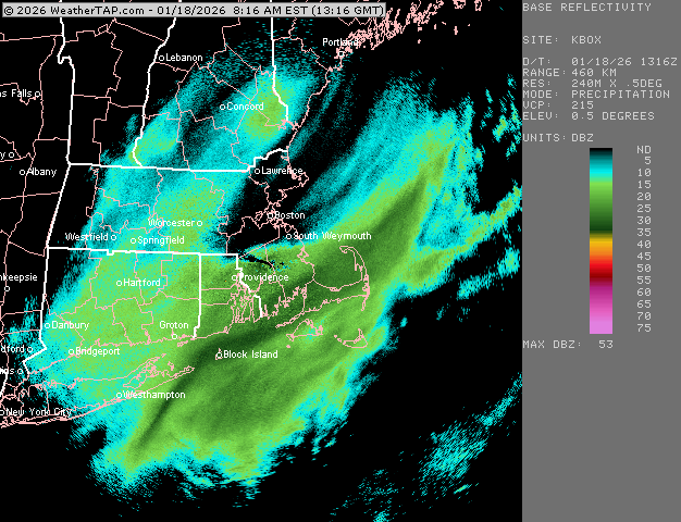
-
Rise of the Machines: January 18-19 Winter Storm Obs Thread
ORH_wxman replied to WxWatcher007's topic in New England
Could be a SE MA special. The trend since last night has been to reduce the vort curl. That will limit how far west the good stuff makes it.


