ORH_wxman
-
Posts
93,095 -
Joined
-
Last visited
Content Type
Profiles
Blogs
Forums
American Weather
Media Demo
Store
Gallery
Everything posted by ORH_wxman
-
Wow. Legit whiteout here
-
March 2022 Obs/Disc: In Like a Lamb, Out Like a Butterfly
ORH_wxman replied to 40/70 Benchmark's topic in New England
Sfc usually CADs, so yeah…they’d be 37 degree rainstorms with maybe a spike to 50 for a few hours before the front passes. Rinse repeat. That’s why I’ll root for snow well into March unless it’s the rare pattern that can support a 2010 or 2012 where we get lots of 60s and 70s. I have no use for 38 and rain or 48 and sunny. Delay the spring misery as long as possible. -
March 2022 Obs/Disc: In Like a Lamb, Out Like a Butterfly
ORH_wxman replied to 40/70 Benchmark's topic in New England
Yep. Might as well get some threats in that pattern rather than talk about how nice the 47F faux warmth feels with -5C 850 temps….or actually freezing our balls off when the occasional -20c shot gets us. -
March 2022 Obs/Disc: In Like a Lamb, Out Like a Butterfly
ORH_wxman replied to 40/70 Benchmark's topic in New England
GFS trying to make 3/5-6 interesting -
March 2022 Obs/Disc: In Like a Lamb, Out Like a Butterfly
ORH_wxman replied to 40/70 Benchmark's topic in New England
EPS looks pretty cold going into mid-March but the period from like 3/5-3/8 or so looks torchy. -
March 2022 Obs/Disc: In Like a Lamb, Out Like a Butterfly
ORH_wxman replied to 40/70 Benchmark's topic in New England
Lol…I always have told myself that if I become mobile to the point of being able to leave in the middle of a school year (so prob not until after my kids are older), I would flee this place in late March or early April and not return until maybe Memorial Day (maybe earlier if weather permits as you said). Just an abysmal time of the year around here. -
March 2022 Obs/Disc: In Like a Lamb, Out Like a Butterfly
ORH_wxman replied to 40/70 Benchmark's topic in New England
Yeah that vortex needs to come south. As modeled right now it’s too warm. It lifts out on the next panel or two and allows the western storm to cut. -
March 2022 Obs/Disc: In Like a Lamb, Out Like a Butterfly
ORH_wxman replied to 40/70 Benchmark's topic in New England
What a weenie EPS run today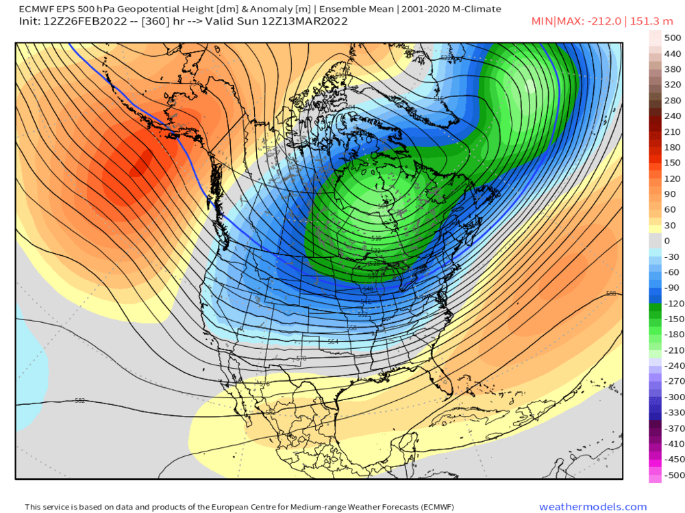
-
March 2022 Obs/Disc: In Like a Lamb, Out Like a Butterfly
ORH_wxman replied to 40/70 Benchmark's topic in New England
Lol. Probably. Although GGEM wasn’t far off from that. Maybe a tenth less LE across the board. GfS looks a little disorganized. -
March 2022 Obs/Disc: In Like a Lamb, Out Like a Butterfly
ORH_wxman replied to 40/70 Benchmark's topic in New England
Ukie is pretty aggressive for the 3/2-3/3 clipper. Basically turns it into a high end advisory/low end warning event. -
March 2022 Obs/Disc: In Like a Lamb, Out Like a Butterfly
ORH_wxman replied to 40/70 Benchmark's topic in New England
“40s” referred to seasonal total. Not percent of normal. A low 40s total in ORH is like 60% of average. -
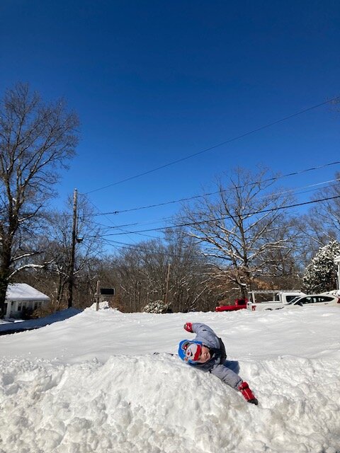
Bluebird day after 9.5”. Always fun for the kids
-
Yeah once you dryslot above 700mb, it gets difficult to maintain heavy rates. We saw the snow continue most of yesterday but the truly heavy stuff down in SNE and S NH shut off late morning once the 500-700 layer dryslot punched through. Probably a good nugget to keep in the back of our minds on the next one.
-
March 2022 Obs/Disc: In Like a Lamb, Out Like a Butterfly
ORH_wxman replied to 40/70 Benchmark's topic in New England
I think you need to use standard deviation to really determine ratter status. Some places hardly ever get under 50% of their average. ORH hasn’t had a winter below 50% of their average since 1999-2000 when they had 30.2”. But years like 2001-2002, 2011-2012, and 2015-2016 all had in the 40s and I’d consider them ratters. -
ORH had 0.95” (but 8.2” of snow so it was dense) but that’s the closest I found to an inch for first order sites. Didn’t see cocorahs down here yet. But yeah, this was a little underperforming on the QPF. I was pretty sure there would be a stripe of 12-15” amounts from this but I was wrong. I figured as the strong ML warm front slowed and then slid east, someone on the north side of that would just get croaked but it seems like it just couldn’t maintain intensity as it did that. We’ve seen these types of 12”+ amounts previously when you get the whole thing slowing and then sliding east (2/5/14 or 12/19/08).
-
March 2022 Obs/Disc: In Like a Lamb, Out Like a Butterfly
ORH_wxman replied to 40/70 Benchmark's topic in New England
Yeah you’d prob need like a moderate storm of 6-10” and then cash in on a big dog of 12-18”+. Maybe another smaller nuisance event or two mixed in there somewhere before mid-April and there’s your 30”+ to get you to normal. -
The 1980s were very anomalous when it comes to snow in New England. It’s not a great baseline to use.
-
About 9.5” total. Depth currently a little over 8” as the stuff from earlier this morning settled a bit.
-
March 2022 Obs/Disc: In Like a Lamb, Out Like a Butterfly
ORH_wxman replied to 40/70 Benchmark's topic in New England
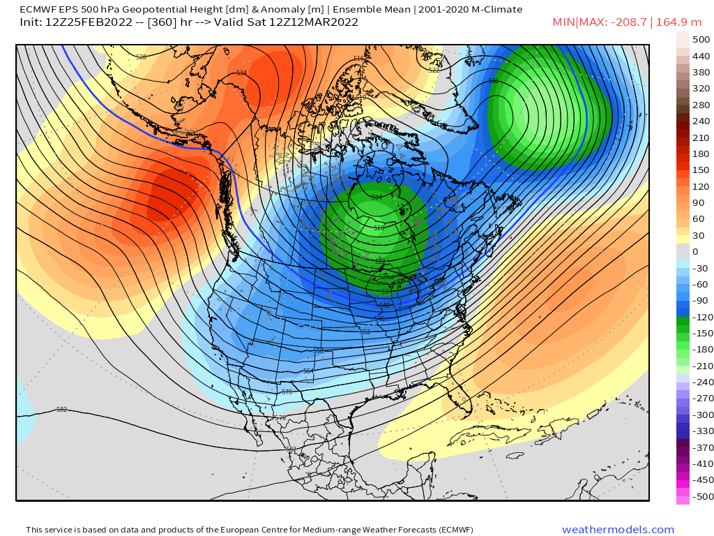
The PNA index just measures where the height anomalies are within the PNA domain loading pattern. So because we have higher heights out toward the Aleutians and lower heights over western Canada, it’s going to produce a -PNA (RNA) number. It doesn’t mean the PV has to get sucked down into Washington and Oregon like it did back in December during that obscene pattern. The PV being over Hudson Bay will help with overrunning threats that might otherwise be cutters. You can see though how the mean trough is further east by the end of EPS run though. It’s more sitting over the central US instead of further west so it would give us a better shot at a Miller B. -
March 2022 Obs/Disc: In Like a Lamb, Out Like a Butterfly
ORH_wxman replied to 40/70 Benchmark's topic in New England
Looks like a 2-3 days moderation after the 5th or so....but EPS and GEFS are both pretty bullish for continued winter threats after that. The trough actually moves east a bit, so perhaps we'd have more support for a coastal after 3/10 or so. Here's the LR EPS....GEFS is pretty similar too. (edit: GEFS was posted above while I was making this post)
-
Euro lost them...GFS/GGEM/Ukie still have at least one of them. Ukie still has both, GFS likes 3/1 while GGEM likes 3/3.
-
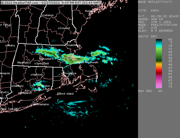
NAM and esp 3km NAM at 18z have another round between 6-8pm hitting eastern MA/SE NH....but HRRR and RAP not as excited....more like a flurries on the latter while the 3km NAM probably has another inch or so from that. So some discrepancy on the short term guidance for later...we'll just have to watch.
-
You're telling me that George had inflated expectations on a storm? Hard to believe.....
-
Models did bad with the CF....never got here even though most of them pushed it like 10 miles west of me. Swinging back east faster too than most guidance had it. Legit flash freeze potential near the coast where it got to 33-34F for several hours.
-
What did you have in the 1/7 storm? I probably have a but more than you because of that one storm. I had like a 10-11" of fluff in that one.