ORH_wxman
-
Posts
93,095 -
Joined
-
Last visited
Content Type
Profiles
Blogs
Forums
American Weather
Media Demo
Store
Gallery
Everything posted by ORH_wxman
-
March 2022 Obs/Disc: In Like a Lamb, Out Like a Butterfly
ORH_wxman replied to 40/70 Benchmark's topic in New England
3/12-3/20 is definitely the time frame for something decent. I’d punt 3/7-8 south of NNE. That one looks putrid. -
March 2022 Obs/Disc: In Like a Lamb, Out Like a Butterfly
ORH_wxman replied to 40/70 Benchmark's topic in New England
925 is really marginal south of the pike. Could go either way. -
March 2022 Obs/Disc: In Like a Lamb, Out Like a Butterfly
ORH_wxman replied to 40/70 Benchmark's topic in New England
EPS has a western ridge spike around 3/14-3/15....if we've got one more big dog left this season, that's probably the most likely period to get it....tons of cold around too when that happens. We'll see how this looks in another few days.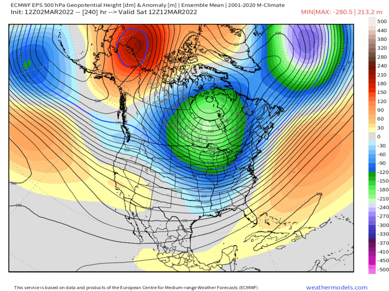
-
March 2022 Obs/Disc: In Like a Lamb, Out Like a Butterfly
ORH_wxman replied to 40/70 Benchmark's topic in New England
Today's guidance is breaking it down a little faster than yesterday too.....so I think we have about a 7-8 day window between 3/12-3/20 IMHO. Any western ridging during that period will have to be watched since there will be plenty of cold loading already. Things could obviously change again, but as of now, that looks like the prime period if we have one more big dog threat in us....STJ down south is still ejecting shortwaves too from time to time....so if we can line up all the ducks, then there's a chance. -
March 2022 Obs/Disc: In Like a Lamb, Out Like a Butterfly
ORH_wxman replied to 40/70 Benchmark's topic in New England
The block is over the Bering strait prior to 3/10...it rolls into a more favorable position after that further east. It might not be technically as strong as it is on 3/9 or 3/10 (though we won't know for sure until we are closer), but it's effectively more potent there in terms of impacting our sensible wx. -
March 2022 Obs/Disc: In Like a Lamb, Out Like a Butterfly
ORH_wxman replied to 40/70 Benchmark's topic in New England

-
March 2022 Obs/Disc: In Like a Lamb, Out Like a Butterfly
ORH_wxman replied to 40/70 Benchmark's topic in New England
Yeah way up north might be able to salvage 3/7.....we'll see. -
March 2022 Obs/Disc: In Like a Lamb, Out Like a Butterfly
ORH_wxman replied to 40/70 Benchmark's topic in New England
Aside from maybe a brief burst of moderate to heavy snow tonight, close the shades until after 3/10....the pattern still does look quite good after that point though. I'd be surprised if we don't have another legit threat. May not pan out, but hard to see not having a threat or two. -
March 2022 Obs/Disc: In Like a Lamb, Out Like a Butterfly
ORH_wxman replied to 40/70 Benchmark's topic in New England
Been getting weenie flakes here for the past 10-15 min. -
March 2022 Obs/Disc: In Like a Lamb, Out Like a Butterfly
ORH_wxman replied to 40/70 Benchmark's topic in New England
Seems like the blocking goes nuclear after the 9th or 10th though. I think we'll have chances mid-month...but I agree. If we could have kept this weekend south and added to the snow pack, it would have added to the wintry appeal...but when you are dealing with a White Snake winter, you take what you can get. Deal with the meltouts. -
March 2022 Obs/Disc: In Like a Lamb, Out Like a Butterfly
ORH_wxman replied to 40/70 Benchmark's topic in New England
Fixed your post. -
March 2022 Obs/Disc: In Like a Lamb, Out Like a Butterfly
ORH_wxman replied to 40/70 Benchmark's topic in New England
Yeah those are your personal preferences. They just aren't everyone's. When I was in Texas, it was not nearly as bad to tolerate playing golf midday in the summer when I went to courses northwest of Austin in 100F heat with dews in the 50F range as it was when I'd play further east when it was 94/73. The latter was so much more taxing on the body. -
March 2022 Obs/Disc: In Like a Lamb, Out Like a Butterfly
ORH_wxman replied to 40/70 Benchmark's topic in New England
I don't want 57 and overcast or drizzle...I just said I'd take it over nasty 90s with 70s dews. Ideal weather is warm and dry. I play golf. I hike. I take my kids outdoors a lot to ride bikes and playgrounds. Those all suck ASS in hot and humid weather just as much as 50s does (hiking actually might be way better with temps in the 50s). -
March 2022 Obs/Disc: In Like a Lamb, Out Like a Butterfly
ORH_wxman replied to 40/70 Benchmark's topic in New England
If RGEM is correct, then I could see a nicer looking swath of snow....but GFS is bringing the low almost on top of me so I'd expect the best to be north....there will be a band of WAA precip ahead of it, but it's not as ideal as something like the RGEM which would prob have a quasi-stationary band somewhere down in SNE. If we can trend everything south another tick, then maybe it gets interesting for potential advisory snows. -
March 2022 Obs/Disc: In Like a Lamb, Out Like a Butterfly
ORH_wxman replied to 40/70 Benchmark's topic in New England
Spring is mostly dogshit around here....it's somewhat better where you are being WOR and southwest, but out east, it's usually trying to put lipstick on a pig when hyping up spring. Once in a while we get a great one, but usually I'm expecting pretty regular rounds of garbage weather (sheet drizzle, cold rain, lot of clouds, etc) -
March 2022 Obs/Disc: In Like a Lamb, Out Like a Butterfly
ORH_wxman replied to 40/70 Benchmark's topic in New England
Seems like precip might be a bit showery with the best forcing to the north in NNE....but can't rule out an inch or two....esp interior hills. -
March 2022 Obs/Disc: In Like a Lamb, Out Like a Butterfly
ORH_wxman replied to 40/70 Benchmark's topic in New England
I'll take 57 and drizzle over 92/70 any day unless I'm going to the beach or pool. -
March 2022 Obs/Disc: In Like a Lamb, Out Like a Butterfly
ORH_wxman replied to 40/70 Benchmark's topic in New England
If you can have sun with low wind this time of the year, it's usually pretty nice. Even when it's cold. It's those nasty CAA windy cold shots that are the worst....that and CAD cold rain. Not looking forward to Thursday's CAA cold shot. -
March 2022 Obs/Disc: In Like a Lamb, Out Like a Butterfly
ORH_wxman replied to 40/70 Benchmark's topic in New England
Nobody honestly knows about snow threats at this point anyway....people might pretend they do, but when you start shortening the wavelengths in March, it becomes even harder to see storms from more than a few days out. I mostly just look to see if there is a cold source that any potential system could tap into...and that ingredient seems to be there mid-month, so to me that says a legit storm could be possible. But can't say anything beyond that. It could just be a 42F day that warms your ass in the seat of the car too. -
March 2022 Obs/Disc: In Like a Lamb, Out Like a Butterfly
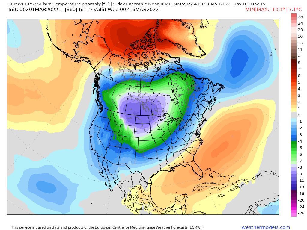
ORH_wxman replied to 40/70 Benchmark's topic in New England
The pattern might bust, but that's probably got some solid cold shots in it if that look pans out. You don't load up Canada with huge negative anomalies like that and usually escape....sometimes you do, but most of the time you will not. -
March 2022 Obs/Disc: In Like a Lamb, Out Like a Butterfly
ORH_wxman replied to 40/70 Benchmark's topic in New England
What's your prediction for the 3/10-3/17 period? -
March 2022 Obs/Disc: In Like a Lamb, Out Like a Butterfly
ORH_wxman replied to 40/70 Benchmark's topic in New England
New normals though....we got rid of a lot of the cold 1980s summers when they updated the normals last year. -
March 2022 Obs/Disc: In Like a Lamb, Out Like a Butterfly
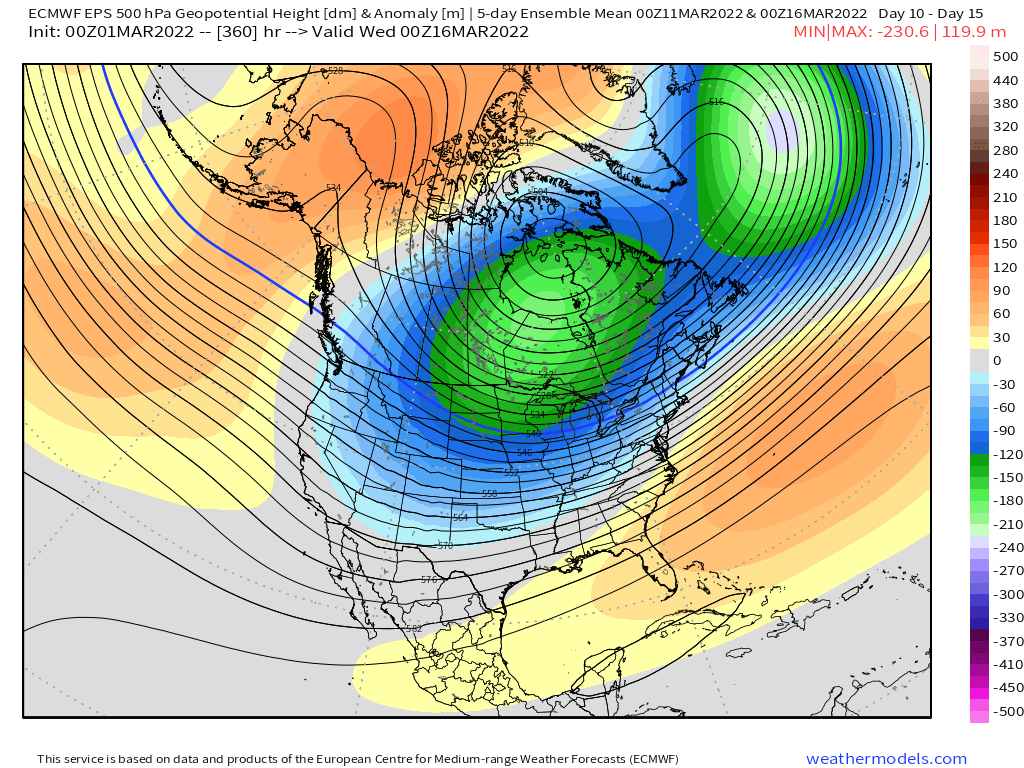
ORH_wxman replied to 40/70 Benchmark's topic in New England
Can't call it on snow threats yet with the way the pattern looks after 3/10. Here's the 5 day mean for 00z 3/11 to 00z 3/16...way too much cold loading into the source region.
-
March 2022 Obs/Disc: In Like a Lamb, Out Like a Butterfly
ORH_wxman replied to 40/70 Benchmark's topic in New England
Unless we get CAD'd at the surface which is very possible. Then it's complete trash with maybe a little icing and cold rain. -
March 2022 Obs/Disc: In Like a Lamb, Out Like a Butterfly
ORH_wxman replied to 40/70 Benchmark's topic in New England
Trough out west gets super deep....so the 3/5-3/8 period looks mostly like trash....maybe some brief 'bouts of winter wx on the front end, but I think mid-month (beyond 3/10) is a lot more likely for the next real winter threat.