ORH_wxman
-
Posts
93,095 -
Joined
-
Last visited
Content Type
Profiles
Blogs
Forums
American Weather
Media Demo
Store
Gallery
Everything posted by ORH_wxman
-
March 2022 Obs/Disc: In Like a Lamb, Out Like a Butterfly
ORH_wxman replied to 40/70 Benchmark's topic in New England
Sucks up there in March…that’s supposed be prime skiing time in NNE. Maybe 60 is ok on reggaefest weekend at the end of March if it’s sunny/dry with the slopes covered in feet of snow. NNE has been pretty unlucky the past couple Marches and this one isn’t starting good either. I would’ve figured they’d do well with the look the past week and upcoming week but it hasn’t really happened. Phin’s area is probably due for one of those 50-60 inch months in March. -
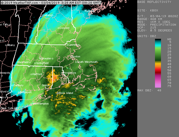
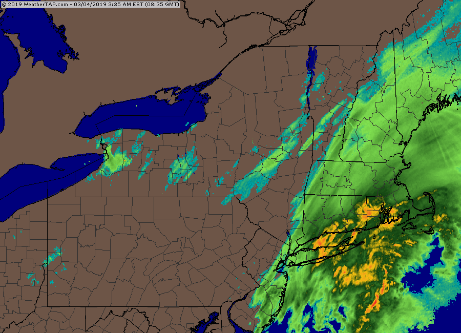
The Mar 2, 2019 storm was kind of disappointing in that for a couple runs it was absolutely crushing E MA/RI. We’re talking like a foot of snow…it ended up weaker and south so it was just an advisory type event in the end….but that would have been something to get back to back 12”+ storms 2 days apart.
-
March 2022 Obs/Disc: In Like a Lamb, Out Like a Butterfly
ORH_wxman replied to 40/70 Benchmark's topic in New England
I’d look at two periods…first one is maybe 3/11 where a front running wave tries to get us. Not super excited about that one but it’s been on and off guidance for a few cycles now. The better window is prob like 3/14-3/17. There’s a western ridge that spikes a bit around then (see below EPS)….no guarantees for anything but that is synoptically the best window if we have one more good one in us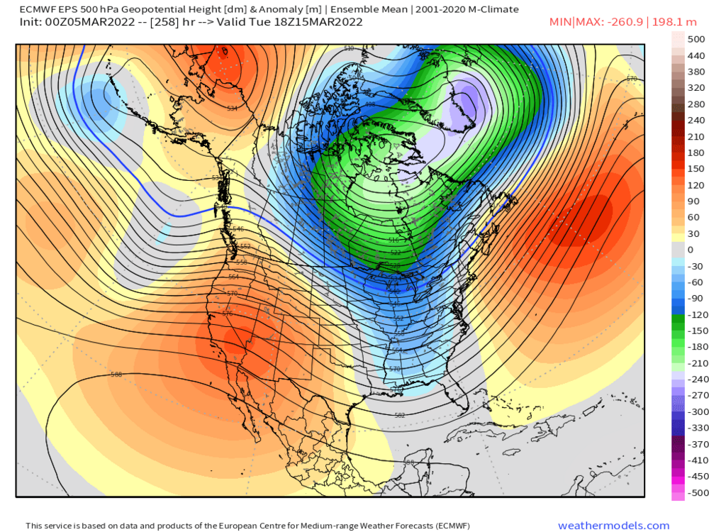
-
March 2022 Obs/Disc: In Like a Lamb, Out Like a Butterfly
ORH_wxman replied to 40/70 Benchmark's topic in New England
3/11-12 never looked that good. Mid-month has more going for it. But some of the guidance has a front-running wave on 3/10 that is kind of interesting. -
March 2022 Obs/Disc: In Like a Lamb, Out Like a Butterfly
ORH_wxman replied to 40/70 Benchmark's topic in New England
I had the grayskull castle. -
March 2022 Obs/Disc: In Like a Lamb, Out Like a Butterfly
ORH_wxman replied to 40/70 Benchmark's topic in New England
Nice pattern on the 12 Euro:
-
March 2022 Obs/Disc: In Like a Lamb, Out Like a Butterfly
ORH_wxman replied to 40/70 Benchmark's topic in New England
It might have been better to be in LA for that one than here...I think BOS had 2 inches of sand in that while the Cape was getting their 2-3 foot blizzard. Cutoff was really sharp around the canal....even East Wareham had "only" a foot or so. -
March 2022 Obs/Disc: In Like a Lamb, Out Like a Butterfly
ORH_wxman replied to 40/70 Benchmark's topic in New England
The Cape got a few good ones in the 1980s....my PTSD storm in Feb 1989 smoked them too. They had over a foot in the Dec '82 storm too (the famous snow plow game at Foxborough) -
March 2022 Obs/Disc: In Like a Lamb, Out Like a Butterfly
ORH_wxman replied to 40/70 Benchmark's topic in New England
3 and a half inches of QPF with 28 inches of snow.....man pack. -
March 2022 Obs/Disc: In Like a Lamb, Out Like a Butterfly
ORH_wxman replied to 40/70 Benchmark's topic in New England
That was another big interior season....coast struggled (except the Cape got a private blizzard) -
March 2022 Obs/Disc: In Like a Lamb, Out Like a Butterfly
ORH_wxman replied to 40/70 Benchmark's topic in New England
2000-2001 incoming -
March 2022 Obs/Disc: In Like a Lamb, Out Like a Butterfly
ORH_wxman replied to 40/70 Benchmark's topic in New England
First time for everything....ORH hadn't seen even 3 consecutive winters without a 10"+ storm on record from 1892-1988....then with perfect precision after I move back to ORH from Texas as a little kid, we get not only 3 in a row, but FOUR in a row without a 10"+ storm. Maybe you get that in Methuen after moving there like I did with ORH. -
March 2022 Obs/Disc: In Like a Lamb, Out Like a Butterfly
ORH_wxman replied to 40/70 Benchmark's topic in New England
Too bad we couldn't lock in the GGEM....like 2 feet of snow next weekend from 2 systems. What a clown model that is. -
March 2022 Obs/Disc: In Like a Lamb, Out Like a Butterfly
ORH_wxman replied to 40/70 Benchmark's topic in New England
No sustained warmth at all on guidance...White Snake pattern. Hope for one more big dog to track mid-month. -

-
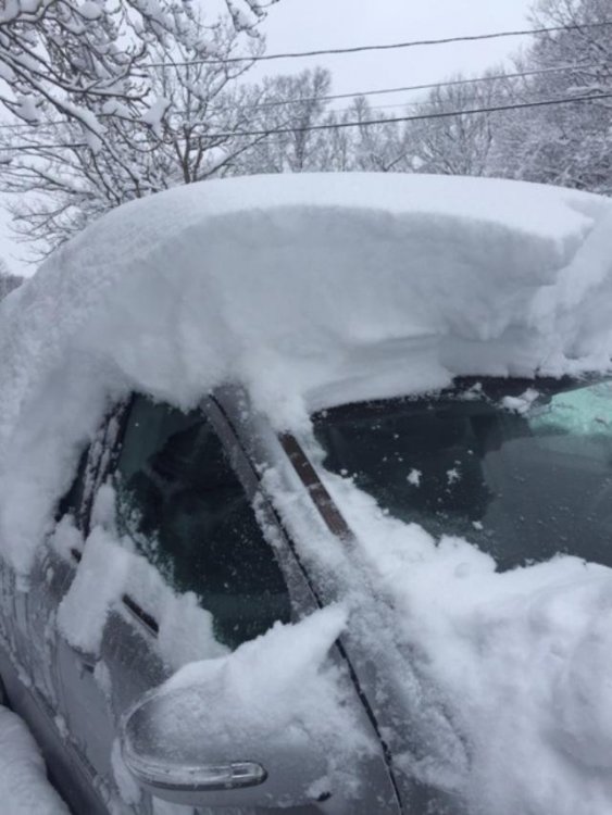
That 3/4/19 storm had some of the heaviest rates I've had in the last 5+ years. I had 4-5 inches per hour for a while. Managed 17" of which most fell in about 4 hours.
-
March 2022 Obs/Disc: In Like a Lamb, Out Like a Butterfly
ORH_wxman replied to 40/70 Benchmark's topic in New England
18z GFS way south now....lol. -
March 2022 Obs/Disc: In Like a Lamb, Out Like a Butterfly
ORH_wxman replied to 40/70 Benchmark's topic in New England
Yeah I don't really like that storm very much for winter wx...could change, but it seems too early in the pattern shift for a good snow event. Our window of potential is more between 3/12-3/20 IMHO....prob centered in the 3/13-3/17 time range. -
March 2022 Obs/Disc: In Like a Lamb, Out Like a Butterfly
ORH_wxman replied to 40/70 Benchmark's topic in New England
GFS might be interesting for 3/10 -
March 2022 Obs/Disc: In Like a Lamb, Out Like a Butterfly
ORH_wxman replied to 40/70 Benchmark's topic in New England
Yeah I remember the torch March talk a couple weeks back. This early March cold period is actually verifying pretty nicely, but we couldn't get anything to amplify into the cold.... We'll see if the reload mid-month bears fruit. Almost reminds me a little of how Mar 2007 unfolded. We started the month brutally cold (colder than this outbreak....it was breaking records). Then we had a big relaxation between the 10th and 15th or so. I even remember being near 70F a couple days before the big 3/16-17/07 storm. Then we went cold again for the storm and up until the final week when we torched again. We snuck in another small event on 3/24 before it torched. -
March 2022 Obs/Disc: In Like a Lamb, Out Like a Butterfly
ORH_wxman replied to 40/70 Benchmark's topic in New England
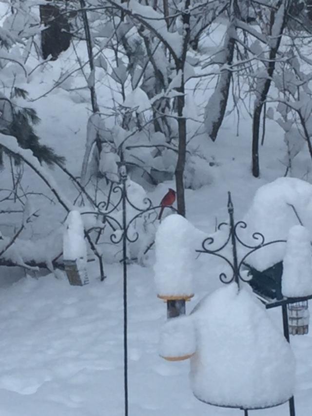
Winter hill this morning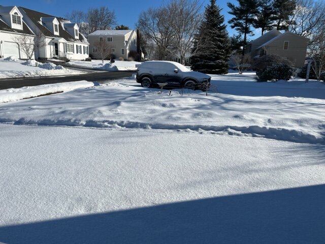
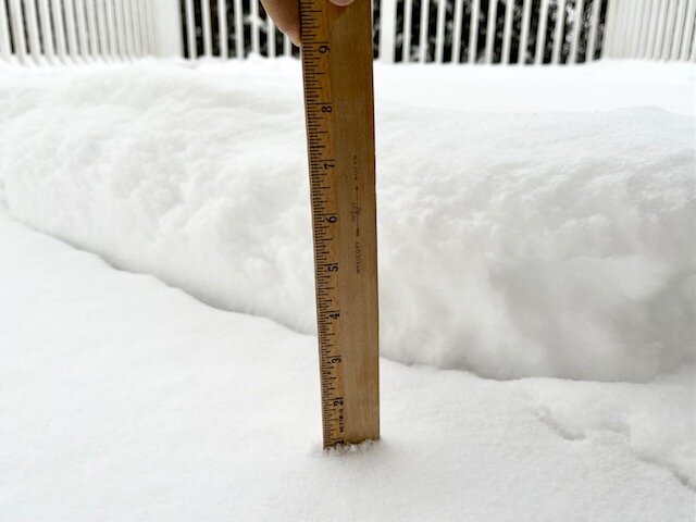
-
March 2022 Obs/Disc: In Like a Lamb, Out Like a Butterfly
ORH_wxman replied to 40/70 Benchmark's topic in New England
Monday is toast for us....enjoy the rain. NNE could cash in on that. After Monday we could get something....some guidance trying for 3/12 but I feel like more toward 3/14-3/15 period is a better setup. -
March 2022 Obs/Disc: In Like a Lamb, Out Like a Butterfly
ORH_wxman replied to 40/70 Benchmark's topic in New England
Seems like the pike was pretty close to the dividing line. 925 was pretty dicey south of that. AWT. -
March 2022 Obs/Disc: In Like a Lamb, Out Like a Butterfly
ORH_wxman replied to 40/70 Benchmark's topic in New England
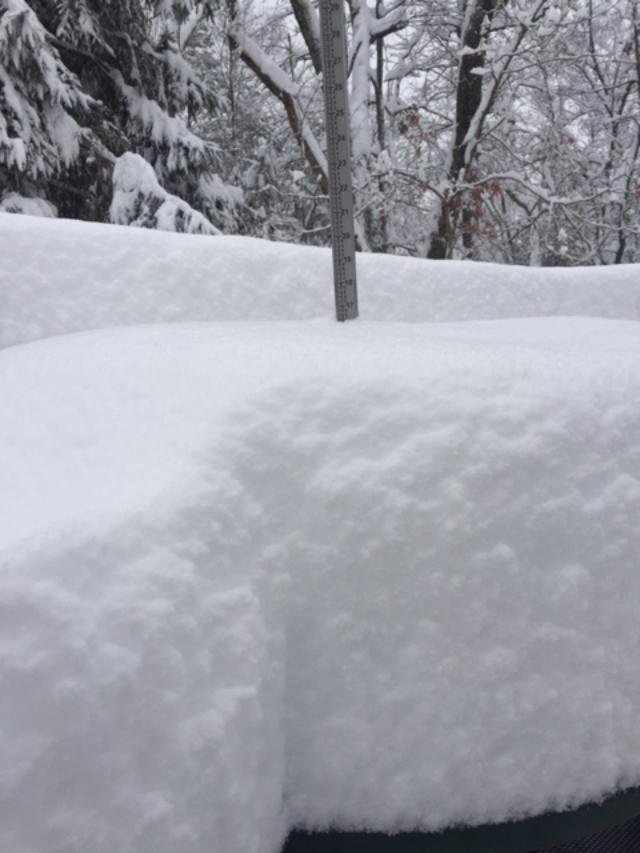
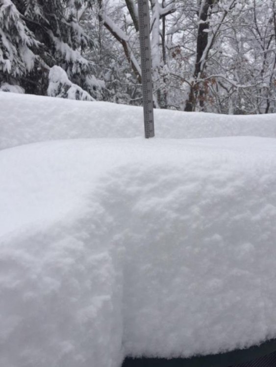
Almost an inch on winter hill. -
March 2022 Obs/Disc: In Like a Lamb, Out Like a Butterfly
ORH_wxman replied to 40/70 Benchmark's topic in New England
That anniversary date (3/13) looks pretty favorable right now. Another pretty good storm happened on that date too 25 years before that. Hopefully we get one more biggie to track.