ORH_wxman
-
Posts
93,095 -
Joined
-
Last visited
Content Type
Profiles
Blogs
Forums
American Weather
Media Demo
Store
Gallery
Everything posted by ORH_wxman
-
March 9: Little Critter that could part 2.
ORH_wxman replied to Sey-Mour Snow's topic in New England
Kevin whines non-stop anytime people talk about areas outside of northern CT. -
March 9: Little Critter that could part 2.
ORH_wxman replied to Sey-Mour Snow's topic in New England
Yeah prob starts there around 1...maybe a little sooner. Hasn't started here yet either. Having the bulk after 3pm will definitely help with the sun angle issues, though anyone inside those heavier bands will overwhelm the sun angle. But certainly for when it lightens up a bit, it's good to have the sun lower. -
March 9: Little Critter that could part 2.
ORH_wxman replied to Sey-Mour Snow's topic in New England
PSF reporting heavy snow now in that band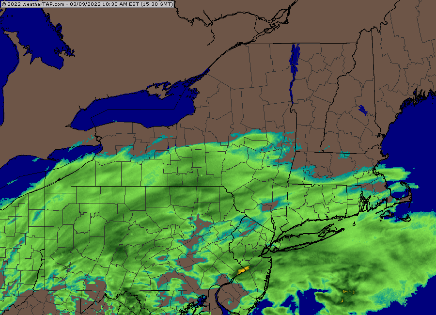
-
March 9: Little Critter that could part 2.
ORH_wxman replied to Sey-Mour Snow's topic in New England
They have a couple additional advantages....some elevation and the best snows there won't be until after 3-4pm, so they will be doing it with the sun getting low in the sky. -
March 9: Little Critter that could part 2.
ORH_wxman replied to Sey-Mour Snow's topic in New England
Someone up in N ORH county or monads is gonna get a little fluff bomb I think...maybe back to N Berks and Mitch in S VT too. Best H7 fronto sort of goes right along the pike and a little north of that is where the jack will be IMHO....really good crosshair sig up in that area too. -
March 9: Little Critter that could part 2.
ORH_wxman replied to Sey-Mour Snow's topic in New England
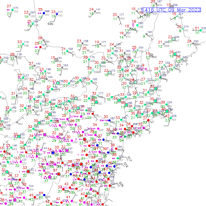
The stuff out in PA is really where the best forcing is....and you can see it on the obs too, lots of 1/4 and 1/2 SM obs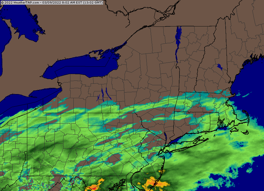
-
March 9: Little Critter that could part 2.
ORH_wxman replied to Sey-Mour Snow's topic in New England
There’s going to be a band up north somewhere (whether it’s the pike, rt 2, or near the NH border) that probably does better than forecasts. Prob like a 6” fluff job because the crosshair sig is really good there. -
March 9: Little Critter that could part 2.
ORH_wxman replied to Sey-Mour Snow's topic in New England
06z runs are coming in pretty zonked so far after 00z was a bit tame. -
March 9: Little Critter that could part 2.
ORH_wxman replied to Sey-Mour Snow's topic in New England
Euro cut back some from its really bullish 12z solution. More toward the middle of the model consensus now. I think most of those 2-4” lolli 5” forecasts are good. Someone might get smoked with a 6 spot if they can get into a band but I wouldn’t actually forecast that for a specific spot. But someone with a bit of elevation and north could do it since there’s a strong crosshair sig up there. Maybe someone in the Berkshires. -
March 2022 Obs/Disc: In Like a Lamb, Out Like a Butterfly
ORH_wxman replied to 40/70 Benchmark's topic in New England
Time to see if Euro is going to pull of the coup or not like the old days. I ain’t buying it. I bet it goes back west. -
March 9: Little Critter that could part 2.
ORH_wxman replied to Sey-Mour Snow's topic in New England
The extremely low dews are the sign that the airmass is pretty cold from a wetbulb perspective. Pretty classic for March actually. -
March 9: Little Critter that could part 2.
ORH_wxman replied to Sey-Mour Snow's topic in New England
Not surprised it's cooling a bit at the sfc....925 is pretty damned cold to be supporting 33-34F at the sfc. -
Most of that was already priced into the market the last few days when we saw the initial spike. It’s hard to say exactly how high it goes because the market can be irrational for periods of time even though it eventually settles onto the supporting fundamentals. There’s multiple variables too…is opec going to pump more? Will the United States signal that they are going to ramp up their own production going forward? Does the world economy stay tanking? (All of those would act to try and bring prices down)
-
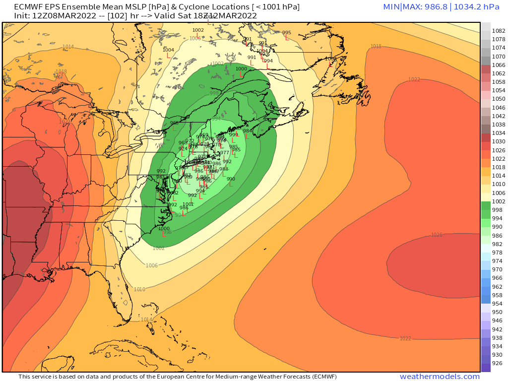
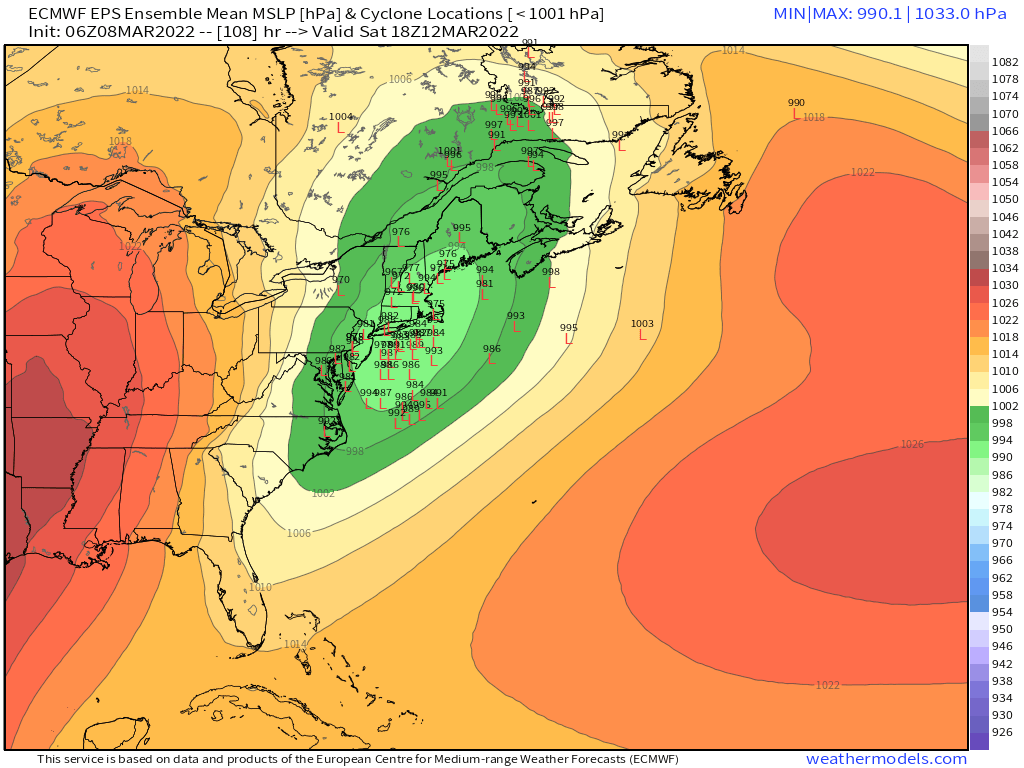
March 2022 Obs/Disc: In Like a Lamb, Out Like a Butterfly
ORH_wxman replied to 40/70 Benchmark's topic in New England
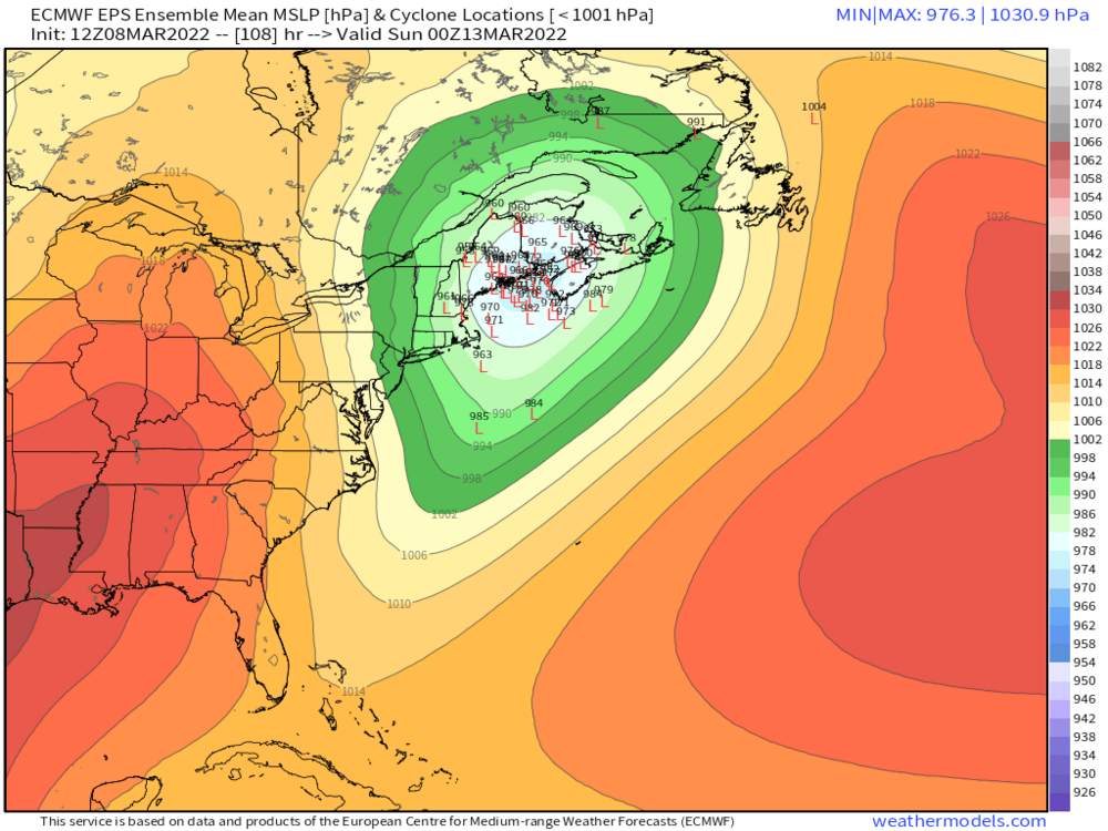
12z EPS
-
March 9: Little Critter that could part 2.
ORH_wxman replied to Sey-Mour Snow's topic in New England
Tries to prolong it too in the evening with that nice closed off low at 925 and almost does it at 850 -
March 2022 Obs/Disc: In Like a Lamb, Out Like a Butterfly
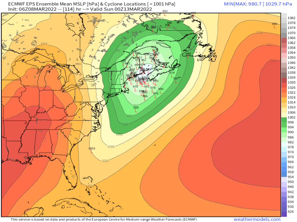
ORH_wxman replied to 40/70 Benchmark's topic in New England
Euro may have trended even a little more SE for Saturday from 00z, but pretty close. That would actually be interesting for many. But want to see a bit more support before really buying something like that. -
March 9: Little Critter that could part 2.
ORH_wxman replied to Sey-Mour Snow's topic in New England
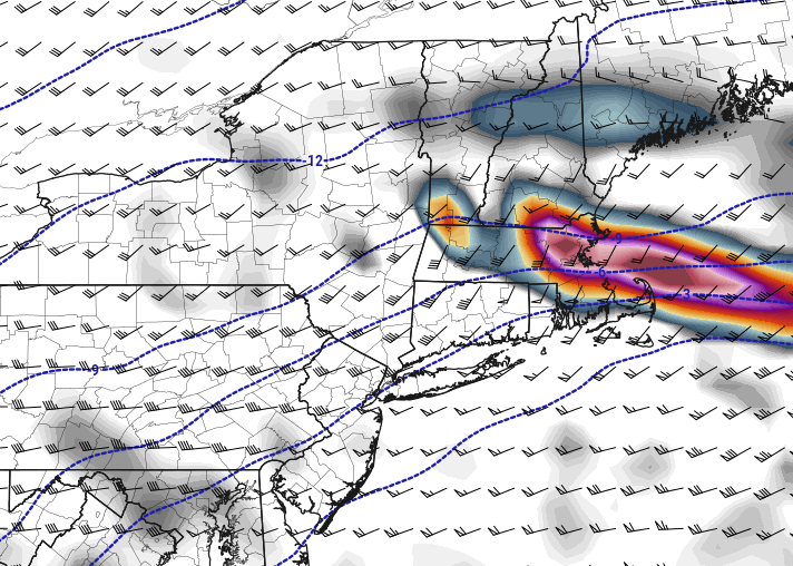
Someone will prob do really well in a band. There's a pretty potent banding sig....so I wonder if it could be one of those things where even down in the valley someone gets 4-5" if they end up under a band for 2-3 hours but then not too far away where they miss the meat of the band is struggling in 33F 1 mile vis SN-. 925mb is like -4C so once under a band, I think it would wetbulb/latently cool down to 32F near the sfc. Def a steep low level lapse rate though so elevation will do well...esp if it's lighter. -
March 9: Little Critter that could part 2.
ORH_wxman replied to Sey-Mour Snow's topic in New England
Woah...Euro gone wild...esp down in CT. Large area of over half inch LE. -
March 2022 Obs/Disc: In Like a Lamb, Out Like a Butterfly
ORH_wxman replied to 40/70 Benchmark's topic in New England
Yeah I'm selling any snow here except maybe a touch at the end...not even sure if it's enough to accumulate. -
March 9: Little Critter that could part 2.
ORH_wxman replied to Sey-Mour Snow's topic in New England
Yeah 12 days from the equinox is equivalent to October 1st or OCtober 2nd sun angle. -
March 2022 Obs/Disc: In Like a Lamb, Out Like a Butterfly
ORH_wxman replied to 40/70 Benchmark's topic in New England
I don't think SNE is required to get drenched for NNE to score here (well maybe southeast SNE would need to be)...this has a big longitude component to it. Could be the type of system where it's ripping snow in western MA and western CT right up into VT/NH/W ME while it's raining in eastern Maine -
March 9: Little Critter that could part 2.
ORH_wxman replied to Sey-Mour Snow's topic in New England
It's not going to be a big system I don't think....but there will be some 3-5" amounts I think in areas that get lucky banding while some other areas may have light snow at 33F that has trouble accumulating efficiently. -
March 9: Little Critter that could part 2.
ORH_wxman replied to Sey-Mour Snow's topic in New England
It has some good H7 fronto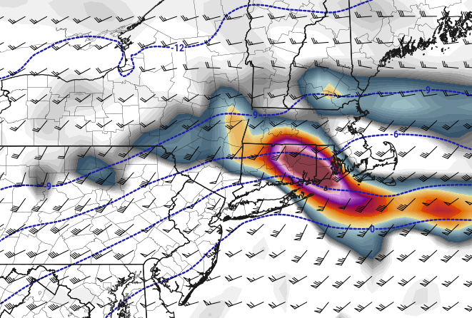
-
March 9: Little Critter that could part 2.
ORH_wxman replied to Sey-Mour Snow's topic in New England
There's some good crosshair sig in there too on a lot of these soundings. -
March 2022 Obs/Disc: In Like a Lamb, Out Like a Butterfly
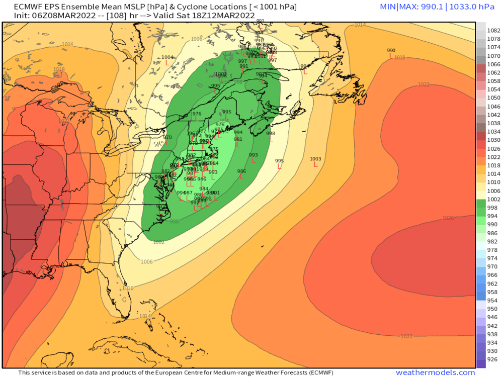
ORH_wxman replied to 40/70 Benchmark's topic in New England
This is looking pretty nice for NNE....we'll see how far southeast the snows can get into SNE. Here's 06z EPS