ORH_wxman
-
Posts
93,095 -
Joined
-
Last visited
Content Type
Profiles
Blogs
Forums
American Weather
Media Demo
Store
Gallery
Everything posted by ORH_wxman
-
She probably did more to help disadvantaged communities in a year with her outreach than most people do in their lifetimes. You are still coming across as an asshole in this thread.
-
March 2022 Obs/Disc: In Like a Lamb, Out Like a Butterfly
ORH_wxman replied to 40/70 Benchmark's topic in New England
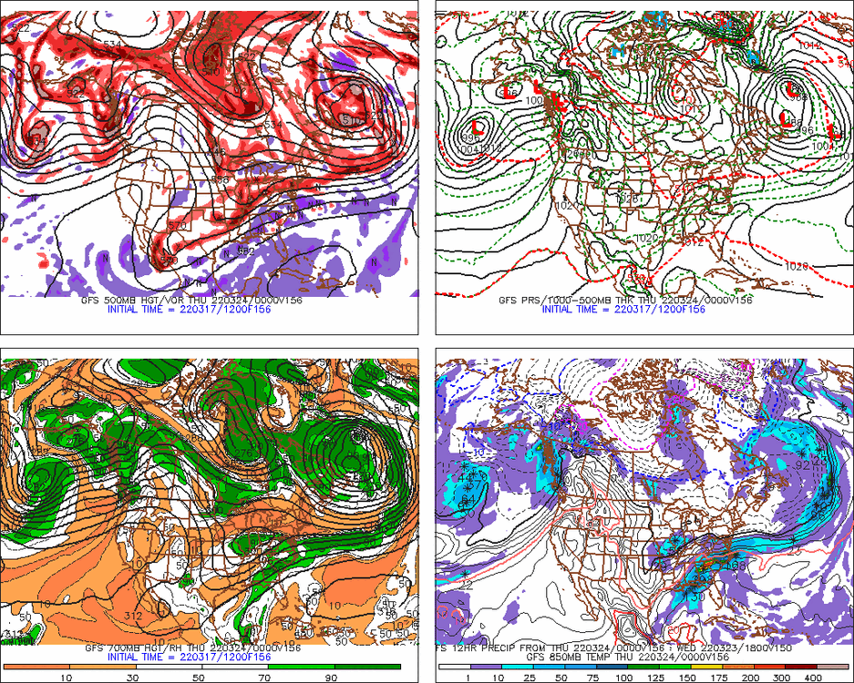
The larger scale features are interesting on the 12z runs....you have the massive PV lobe acting as the 50/50 low in Labrador/New Foundland and a trough ejecting out of the central CONUS. I'd like the trough to be a little more organized....seems kind of disjointed a little and positively tilted, but those are details we know can change easily at this lead time
-
March 2022 Obs/Disc: In Like a Lamb, Out Like a Butterfly
ORH_wxman replied to 40/70 Benchmark's topic in New England
It was...mostly just January and a few fleeting periods in February. I'm still annoyed at December where the pattern wasn't that far from being really good. We just somehow managed to get a -20 sigma PNA when a merely solidly negative PNA would have been fine. -
March 2022 Obs/Disc: In Like a Lamb, Out Like a Butterfly
ORH_wxman replied to 40/70 Benchmark's topic in New England
Wow that sounds almost like a carbon copy of ORH in 1996-1997 going into the blizzard....I think ORH had 54.5" going into the '97 storm. Then 33" from the blizzard. -
March 2022 Obs/Disc: In Like a Lamb, Out Like a Butterfly
ORH_wxman replied to 40/70 Benchmark's topic in New England
Yeah really convoluted blocky setup....could support something pretty big, but it would also be no surprise at all if we got nothing out of it. -
March 2022 Obs/Disc: In Like a Lamb, Out Like a Butterfly
ORH_wxman replied to 40/70 Benchmark's topic in New England
Yeah I was gonna mention that one but we were focusing on big late season storms in crappy winters....and '81-'82 was a good winter even before the April blizzard. At any rate, GFS is still interested in the threat late next week. -
March 2022 Obs/Disc: In Like a Lamb, Out Like a Butterfly
ORH_wxman replied to 40/70 Benchmark's topic in New England
I went to Sunday River that year....they got buried in late January and February 1997. -
March 2022 Obs/Disc: In Like a Lamb, Out Like a Butterfly
ORH_wxman replied to 40/70 Benchmark's topic in New England
While it's nothing compared to 1997, April 2016 also had a very cold moderate snow event after a garbage season. 1944 also had a pretty large storm around the equinox after a pathetic winter. -
March 2022 Obs/Disc: In Like a Lamb, Out Like a Butterfly
ORH_wxman replied to 40/70 Benchmark's topic in New England
I'm not sure if missing out on a moderate event in late March is a defining feature of a rat season. -
Both times it happened to me here was in early May. They just mangled them and bent the metal posts they were on as if they were a paper clip. The power it must have taken was impressive.
-
March 2022 Obs/Disc: In Like a Lamb, Out Like a Butterfly
ORH_wxman replied to 40/70 Benchmark's topic in New England
Still gotta watch late next week/next weekend....guidance all over the place on that car crash in the north atlantic giving us a 50/50 low and a big trough ejecting from the central CONUS. Could get interesting....it could easily fail too, but worth keeping an eye on for now. -
Mish Michaels went to my alma mater for meteorology. Maybe 11-12 years before me. I met her at in 2002 at the storms conference. Very kind woman. She was always doing outreach programs around Boston helping kids get into science and weather. Tragic loss.
-
March 2022 Obs/Disc: In Like a Lamb, Out Like a Butterfly
ORH_wxman replied to 40/70 Benchmark's topic in New England
AWT -
Decades in forecasting...an analog is just something comparable to another thing. You can use any variable you want for an analog. The analogs were more primitive the further back you go. Some mets would just look at fall temps and precip and compare those to past years. In the late 1980s/1990s, ENSO probably became the major factor in analogs. It became the primary factor once certain distinct patterns were showing up on ENSO that often repeated themselves. (such as cooler wx in the southeast US and warmer in the upper plains during El Ninos) Now we have better observations of solar, QBO, snow cover, etc. New England itself is tougher IMHO because we have a low correlation with ENSO and many other variables compared to places like the southeast or northern plains or Pacific northwest. That's why I have never really attempted seasonal forecasting for winter in New England....but I applaud those who try. Someone will eventually find a better way to forecast here in advance.
-
You can actually do a pretty decent seasonal forecast without looking at a single model....most will look at ENSO conditions along with solar, QBO, etc. Those are real-time obs so they don't require models. But you cannot do a skilled seasonal forecast without looking at past seasons (i.e. analogs). We have to look at them to know how variables like ENSO affect the pattern.
-
There's no such thing as seasonal forecasting without looking at past seasons....unless you are just going to rip and read a CFS or ECMWF seasonal forecast.
-
March 2022 Obs/Disc: In Like a Lamb, Out Like a Butterfly
ORH_wxman replied to 40/70 Benchmark's topic in New England
The cold was only decent for a 2-3 week period in January....otherwise mostly dogshit. I had a lot of "pack days" but so many of them were 2-3" glacier pack days that are not great. I had like 1 snow event all winter that fell on top of a pack that was more than 3 inches. This winter was a solid D+/C- here....maybe it can salvage a C/C+ if we get one more decent event. -
March 2022 Obs/Disc: In Like a Lamb, Out Like a Butterfly
ORH_wxman replied to 40/70 Benchmark's topic in New England
Yeah most of my DPW clients would wait until around 4/15 or so unless there was an obvious threat approaching. Though they'd start telling their contractors a little earlier than that sometimes assuming they could probably get away with their domestic supply if an April event happened. -
March 2022 Obs/Disc: In Like a Lamb, Out Like a Butterfly
ORH_wxman replied to 40/70 Benchmark's topic in New England
Most snow events in April and May won't require DPW road crews to do much....at least outside the higher elevations. Late March is a bit more likely to need man power on the roads. -
March 2022 Obs/Disc: In Like a Lamb, Out Like a Butterfly
ORH_wxman replied to 40/70 Benchmark's topic in New England
His clients are most likely concerned with snow when they mean "winter". Though it might depend on who they are....most of my clients back when i worked in the field were DOT/DPW clients so they cared about snow...less about temps unless it was in context with the storm so they could know how much brine or salt they needed. -
Yeah that was a sweet couple of storms. I rode that snowpack into the first couple days of April iirc. prob my best March since 2001. Though 2013 was close.
-
The 2017 storm was one of the better front enders I’ve been in. We had about 14-15” and most of it fell in about 5-6 hours. Very good rates. We never actually changed over to sleet even though I thought we would. Just got mid-level dryslotted and went to cruddy flakes and snow grains. It was a very meaty snow though. Prob 10 to 1 ratios at most. The snow pack easily stuck around until the very end of the month.
-
March 2022 Obs/Disc: In Like a Lamb, Out Like a Butterfly
ORH_wxman replied to 40/70 Benchmark's topic in New England
Yeah the Euro schooled the GFS last storm in the medium range. We’ll see if it’s got it’s mojo back or if it’s still in a dogfight for supremacy. -
March 2022 Obs/Disc: In Like a Lamb, Out Like a Butterfly
ORH_wxman replied to 40/70 Benchmark's topic in New England
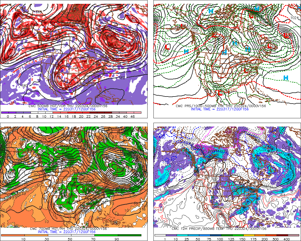
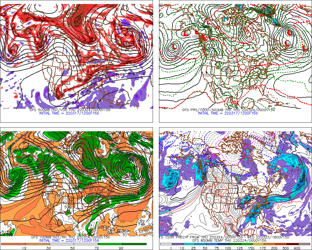
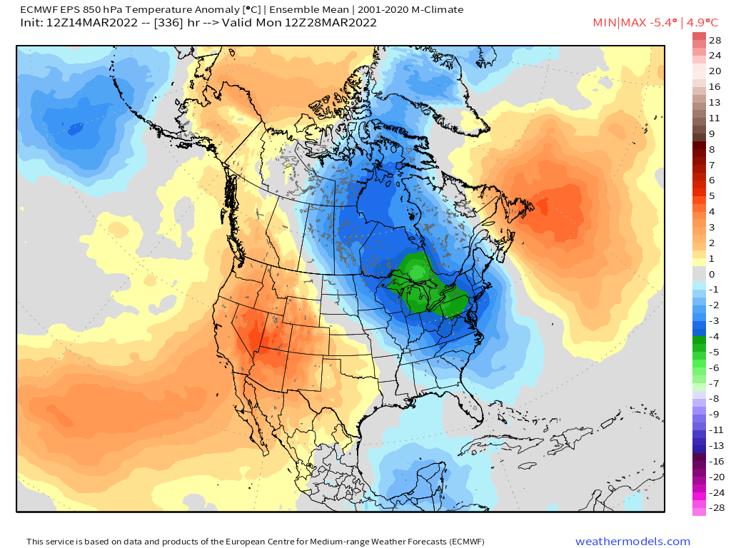
One final hurrah in the final week of March? Heres 5 day EPS mean H5 and then 850 anomaly below…you can see cold source temporarily gets re-established for a winter threat potential…and yea, clown range ensemble caveats still apply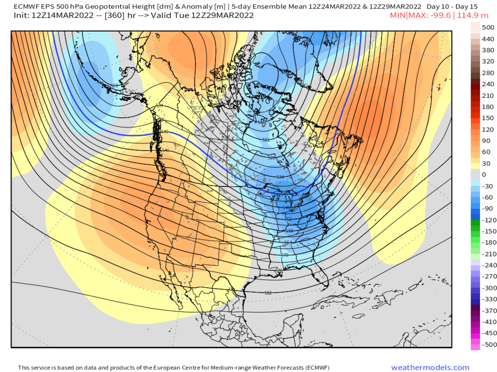

-
March 2022 Obs/Disc: In Like a Lamb, Out Like a Butterfly
ORH_wxman replied to 40/70 Benchmark's topic in New England
Ha, I prob went down those same trails a few days later. It was definitely an incredible ski weekend....some of the best conditions I've skied in when you combine the snow and temps. It was like mid to upper 20s and chalky snow on the groomers despite late March and the woods were just buried. Hopefully similar dumpage this year.