ORH_wxman
-
Posts
93,095 -
Joined
-
Last visited
Content Type
Profiles
Blogs
Forums
American Weather
Media Demo
Store
Gallery
Everything posted by ORH_wxman
-
Saturday, March 26, 2022 Convective Grauple/Small Hail/gusty Showers
ORH_wxman replied to weatherwiz's topic in New England
We had TTs around 60 in the 1/28/10 WINDEX event. The main reason it was so prolific. You had saturation up higher than 500mb. Similar look today except we might not have quite as much lift focused along one area…but the higher lapse rates in the low levels can make up for some of that. Id expect any potent storms or squalls to be frozen precip whether it’s graupel/hail or just flipping to straight snow in the higher terrain. -
March 2022 Obs/Disc: In Like a Lamb, Out Like a Butterfly
ORH_wxman replied to 40/70 Benchmark's topic in New England
June can really suck sometimes. Esp the first 2 weeks. Usually it’s summer by late June but we’ve had some epically bad days in recent years early month. I think it might have been 2015 when we had back to back highs in the 40s early in the month. -
March 2022 Obs/Disc: In Like a Lamb, Out Like a Butterfly
ORH_wxman replied to 40/70 Benchmark's topic in New England
Yeah I’ve actually been on the “first week of April” bandwagon for several days now on a period of interest. Despite the 3/31 system cutting, the blocking pattern remains supportive for a late season threat. -
March 2022 Obs/Disc: In Like a Lamb, Out Like a Butterfly
ORH_wxman replied to 40/70 Benchmark's topic in New England
Guidance is now CADing us for the 3/31 event today....figured it would trend into that trash....couldn't even get a nice warm sector out of the cutter. -
March 2022 Obs/Disc: In Like a Lamb, Out Like a Butterfly
ORH_wxman replied to 40/70 Benchmark's topic in New England
Let’s break some record low maxes for Monday. ORH record is 28F and BOS record is 33F. -
March 2022 Obs/Disc: In Like a Lamb, Out Like a Butterfly
ORH_wxman replied to 40/70 Benchmark's topic in New England
No the longwave pattern is still pretty similar. The storm is there it just cuts well west because of some phasing with the PV lobe in central Canada. It was a period of interest given the pattern but we never got a legit threat out of it. -
March 2022 Obs/Disc: In Like a Lamb, Out Like a Butterfly
ORH_wxman replied to 40/70 Benchmark's topic in New England
Yeah we never had a distinct threat. We had a decent synoptic pattern for 3/31ish but big phasing in central US is going to make that a cutter. There’s still plenty of residual blocking though behind that system so I wouldn’t be surprised if a threat does materialize the first week of April. -
March 2022 Obs/Disc: In Like a Lamb, Out Like a Butterfly
ORH_wxman replied to 40/70 Benchmark's topic in New England
Most of Boston’s 25” fell in about 7-8 hours. It was insane overnight. -
March 2022 Obs/Disc: In Like a Lamb, Out Like a Butterfly
ORH_wxman replied to 40/70 Benchmark's topic in New England
This winter had way too many cutters. We didn't really have a signature period where we were solid cold....even some past rats have had that like Jan 2000 or even Feb '95....this year we couldn't sustain anything. January could've been exceptional had that BGM-track storm on 1/17 been a further east track like might happen the other 99 times out of 100 we simulate that pattern. Then it would've been basically been from 1/7 until month-end of snow/cold combo. -
Saturday, March 26, 2022 Convective Grauple/Small Hail/gusty Showers
ORH_wxman replied to weatherwiz's topic in New England
Gonna have to watch for very intense localized snow squalls too into Saturday night....esp high terrain. The lapse rates are crazy insane for a cold season event. This is the ORH sounding at 03z Saturday evening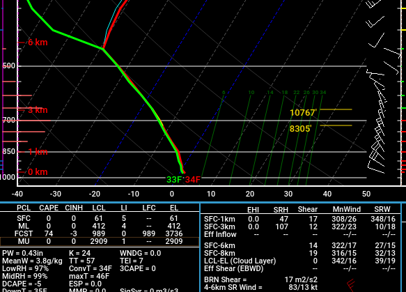
-
March 2022 Obs/Disc: In Like a Lamb, Out Like a Butterfly
ORH_wxman replied to 40/70 Benchmark's topic in New England
You’re talking Boxing Day 2010 right? That was a good one for BOS. They had the CF jackpot. You might be thinking of 12/29/12 which was a lot of rain there and we had 8-10” over the interior. There was also a storm a few days before that on 12/26-27/12 that was a snow to ice situation over the interior but mostly rain on the coast. -
March 2022 Obs/Disc: In Like a Lamb, Out Like a Butterfly
ORH_wxman replied to 40/70 Benchmark's topic in New England
Boxing day was good where scooter was. CF nailed them and up into BOS. Firehose storm was about 15” where I was working in BOS at the time but I think Logan airport had closer to 12-13”. -
March 2022 Obs/Disc: In Like a Lamb, Out Like a Butterfly
ORH_wxman replied to 40/70 Benchmark's topic in New England
They were dumb enough to start getting buds early....they deserve my wrath of anger during useless late season cold. -
March 2022 Obs/Disc: In Like a Lamb, Out Like a Butterfly
ORH_wxman replied to 40/70 Benchmark's topic in New England
Honestly, I'd rather have the -20C 850s if the alternative is "mundane" -15C 850 temps. Might as well try and go for a daily record if it's going to be cold....it's not like getting a high of 35F with wind is going to salvage this dogshit from being any less annoying....might as well be 25F and tag 2022 as the daily record for that date. -
March 2022 Obs/Disc: In Like a Lamb, Out Like a Butterfly
ORH_wxman replied to 40/70 Benchmark's topic in New England
We definitely might sneak in a nape-tanner on Friday if we can clear out well. Saturday is a little more iffy to me.....classic self-destructive sunshine day where it might start decent in the morning, but then by early afternoon, we're popping showers....some prob graupel or snow showers in high terrain. Maybe eastern areas near the coast might hold that off until later in the afternoon as the deep ULL affects the western zones sooner. -
March 2022 Obs/Disc: In Like a Lamb, Out Like a Butterfly
ORH_wxman replied to 40/70 Benchmark's topic in New England
Wouldn't surprise me if we had a threat well into April too....like the first week-plus of the month looks ripe too. I'm bracing for mostly dogshit, but hopefully we can get the stars to line up on one of them. -
March 2022 Obs/Disc: In Like a Lamb, Out Like a Butterfly
ORH_wxman replied to 40/70 Benchmark's topic in New England
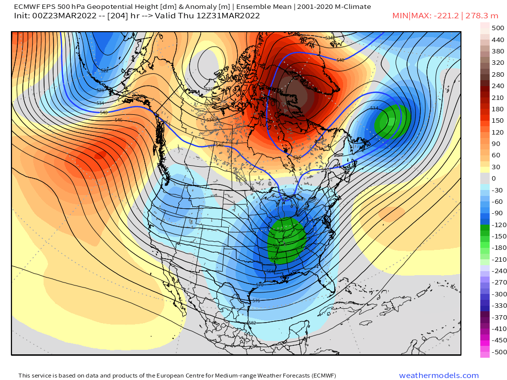
If you're trying to get a good late season snow event, best window on the EPS is for 3/31ish......the synoptic pieces are all there (big Davis Strait block, 50/50 low, and trough moving into the OH Valley)
-
March 2022 Obs/Disc: In Like a Lamb, Out Like a Butterfly
ORH_wxman replied to 40/70 Benchmark's topic in New England
He's been trying the Kevin reverse psych angle for like a week-plus now. If he keeps saying it will never happen, maybe it will? But yeah, even though this is a pretty good pattern coming up for a late season snow threat, you still need a lot to go right...esp down there. Not as hard for a place like ORH county or NW MA. Most will at least see flakes this weekend though under that ULL for Saturday/Sunday. -
March 2022 Obs/Disc: In Like a Lamb, Out Like a Butterfly
ORH_wxman replied to 40/70 Benchmark's topic in New England
It was later than that....pretty sure it was 4/12/13 -
March 2022 Obs/Disc: In Like a Lamb, Out Like a Butterfly
ORH_wxman replied to 40/70 Benchmark's topic in New England
Get ready for some bare ground and teens next week when walking out the door. At least in years like 2017 and 2018, I still had a deep snow pack at this point, so it wasn't all bad having cold....but I Agree this is probably the absolute worst. -
March 2022 Obs/Disc: In Like a Lamb, Out Like a Butterfly
ORH_wxman replied to 40/70 Benchmark's topic in New England
No it could absolutely deliver a winter threat. It’s below normal heights and below normal temps but you can easily get 38F rain on that in late March and early April. -
March 2022 Obs/Disc: In Like a Lamb, Out Like a Butterfly
ORH_wxman replied to 40/70 Benchmark's topic in New England
EPS looks like a ‘rhea pattern all the way to the end of the run. -
March 2022 Obs/Disc: In Like a Lamb, Out Like a Butterfly
ORH_wxman replied to 40/70 Benchmark's topic in New England
Nothing was worse than April '95 IMHO....that was the worst. Full sun with bare ground on April 5th but a high in the mid 20s with 30-40mph CAA gusts. http://www.meteo.psu.edu/fxg1/NARR/1995/us0405.php -
March 2022 Obs/Disc: In Like a Lamb, Out Like a Butterfly
ORH_wxman replied to 40/70 Benchmark's topic in New England
I agree....we've had relatively few "deep CAD" events....where you have strong CAD in the 850-sfc layer and it's torching higher up. It seems those types of events have trended more strung out the past couple winters so they don't end up as mixed....we had a few down here this winter, but the mix zones were relatively narrow with maybe the exception of the 2/4 event. But that kind of matches the longwave pattern....we've had some crappy Pacific setups where the NAO muted the torch at times....like last January/early Feb and this past December where we had a trough digging down to Cabo but a big -NAO block that ground everything to a pulp. -
March 2022 Obs/Disc: In Like a Lamb, Out Like a Butterfly
ORH_wxman replied to 40/70 Benchmark's topic in New England
Too bad we couldn't see one more panel on the Euro....guidance has definitely been targeting month-end to 4/2 range as winter storm potential.