ORH_wxman
-
Posts
93,095 -
Joined
-
Last visited
Content Type
Profiles
Blogs
Forums
American Weather
Media Demo
Store
Gallery
Everything posted by ORH_wxman
-
March 2022 Obs/Disc: In Like a Lamb, Out Like a Butterfly
ORH_wxman replied to 40/70 Benchmark's topic in New England
3rd consecutive pathetic March here....we managed to do ok in 2019 largely on the back of the 3/4/19 system. We're now paying for that good stretch of Marches we had 2013-2019....though down here 2014 was brutal...while you were getting buried up there, we had the frigid cold but not much snow as most of the storms skillfully avoided dropping snow here despite frigid temps on each side of them. -
Also a top 10 coldest March in New England which didn't hurt the pack retention up there....didn't crack a March that cold region-wide again until we did it in 2014 30 years later.
-
That front-running system is the reason the big one was as good as it was. It kept the trailing larger 3/31 shortwave south enough to close off in a great spot for SNE.
-
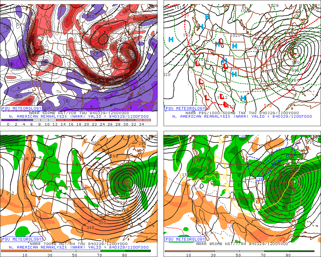
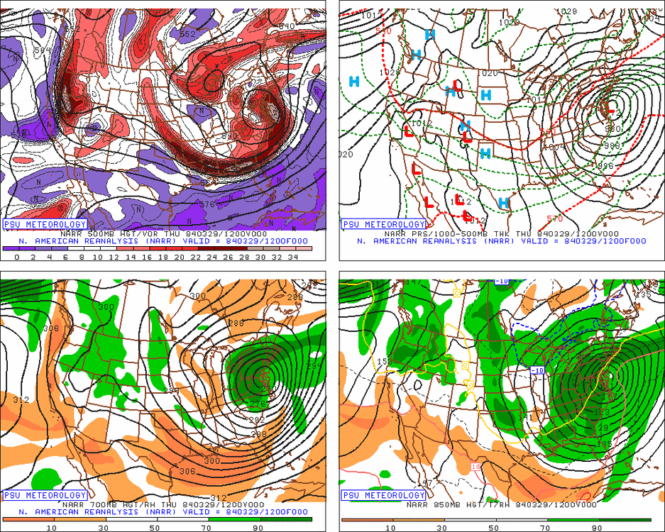
Not a snow map, but the storm was a beast on the synoptic maps
-
The Bruins pull-over starter jacket is epic. LOL Yeah, I wish we had the more modern-looking radar, but even on that loop you can see a ton of 30+ dbz just destroying eastern/central MA and RI for long periods of time....it doesn't take long to add up when you have dbz over 30. We had TSSN when I was getting out of school around 2:15pm....the light was almost a purplish tint likely due to how heavy the snow was and being near peak sun angle...the thunder was only about 4-5 seconds behind so it was less than a mile away. We actually got into a sucker hole for about 90 minutes to 2 hours between roughly 4pm and 6pm. But even at the time I wasn't worried about it because you could see the firehose starting to set up on radar...just ripping out of the ESE from SE MA and RI. What an epic storm that was. I agree that would be crazy on the forums nowadays with the real-time obs of rain flipping to snow. My guess is modern NWP would predict the change-over better than back then. It would still probably happen faster than model guidance predicts though because when you have heights crashing like that, often the model guidance just can't latently cool the atmosphere fast enough compared to reality.
-
Yep…late March is often the “secret” for New England skiing. Most of my best days have come in March. Photos look great everyone…thanks for sharing. I didn’t get out this season which was a bummer but I’ll definitely be getting out next year. My son is ready to hit the slopes for the first time.
-
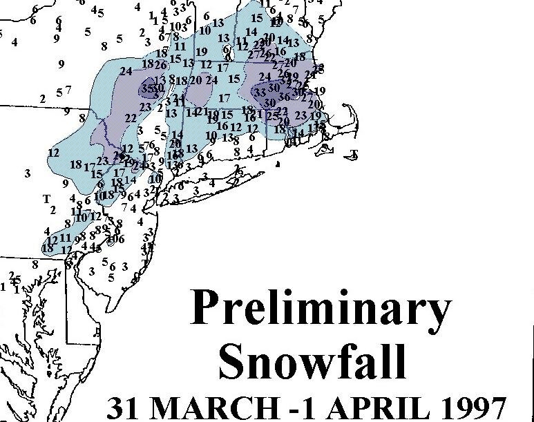
Such an amazing storm. Rain was forecasted to change to snow around early to mid afternoon in ORH. When we started mixing around 930 and flipped completely by 10am, I figured it was going to overperform. But I had no idea just how much it would eventually dump.
-
March 2022 Obs/Disc: In Like a Lamb, Out Like a Butterfly
ORH_wxman replied to 40/70 Benchmark's topic in New England
I was in the grand canyon in July 1991. I couldn’t believe the heat down in the canyon. Then a ranger told us it was actually a bit cooler than usual. I remember looking it up years later and he was right. The southwest was cooler than usual that month. Lol. But it’s all relative. 105 felt hot down in the canyon even if 110 was normal. -
The microburst in Southborough is always really weird to me in that storm. But it was definitely legit. Pretty fun getting blizzard conditions and then a microburst hits.
-
March 2022 Obs/Disc: In Like a Lamb, Out Like a Butterfly
ORH_wxman replied to 40/70 Benchmark's topic in New England
Excellent...might as well set some records if it's going to be like this. -
March 2022 Obs/Disc: In Like a Lamb, Out Like a Butterfly
ORH_wxman replied to 40/70 Benchmark's topic in New England
Congrats to the WOR crowd...cool streamer. -
March 2022 Obs/Disc: In Like a Lamb, Out Like a Butterfly
ORH_wxman replied to 40/70 Benchmark's topic in New England
Snowing lightly here, but no real accumulation....not heavy enough...a few little areas of coating where it swirls into a corner. -
Yeah and they will come down some as interest rates rise.
-
March 2022 Obs/Disc: In Like a Lamb, Out Like a Butterfly
ORH_wxman replied to 40/70 Benchmark's topic in New England
Do you remember late March 1998? I think we hit mid 80s even in ORH during that stretch. Some spots in the CP must have been flirting close to 90F. We went to the Cape to visit my grandparents that Saturday (I think day 2 of the heat dome) and got greeted with 47F and a stiff southwest breeze…even with sun still shining. What an absolute disaster that was. Then of course you prob remember how that heat ended with the backdoor CF from hell. Think we went into the 30s on 4/1 after a cheap midnight high in the 60s of what must have felt like a balmy early summer evening….then seeing 37F stratiform rain and a stiff northeast breeze during the day. -
5% is still pretty low historically speaking. But it’s high for recent years. There’s a good chance it will rise even more and it will start affecting the housing market. We haven’t been above 5% since during the mortgage crisis in the mid-2000s.
-
March 2022 Obs/Disc: In Like a Lamb, Out Like a Butterfly
ORH_wxman replied to 40/70 Benchmark's topic in New England
Yeah I’d agree with this. The ocean is a real detriment the further east you go (and on the south coast of RI). A place like SW CT will absolutely avoid the dogshit days better than us. I’ve seen some days where it’s 85 there and 50s are banked up against the ORH hills and everyone to the east of that. Or you get those days where it’s 80F at 11am in eastern MA but by 2pm it’s 63F on an east wind while people in the CT river valley are jumping in pools at 88F. -
March 2022 Obs/Disc: In Like a Lamb, Out Like a Butterfly
ORH_wxman replied to 40/70 Benchmark's topic in New England
That’s the biggest problem with May and early June. It’s akin to winter in late November and very early December. Yes, we can definitely get snow and cold during that period but it’s almost never sustained enough to keep a pack around and there’s a lot of years we get nothing at all during that period except maybe a couple chilly days here and there to remind you that the seasons are changing…but nobody would call it deep winter when you have a couple days below freezing mixed with a cutter and a downslope dandy torch day. Same applies to summer season. We can easily pick off a few mid 80s (and 90+ in the torch downslope spots) in late May and early June but so frequently it will be mixed in with some 52F clunkers on an east wind and some years we don’t even sniff the heat until mid/late June at all. Those 73-76F days are awesome, don’t get me wrong because I’d love to keep that all summer, but nobody would really call it deep summer where you go to the beach and pools just like nobody is confusing highs around 40 near T-day as deep winter. -
March 2022 Obs/Disc: In Like a Lamb, Out Like a Butterfly
ORH_wxman replied to 40/70 Benchmark's topic in New England
July and August are usually pretty summery, but we aren't discussing that part of summer....it was late may and early June. This is like claiming our winters are pretty cold and snowy after someone called you out for saying Thanksgiving is deep winter. -
March 2022 Obs/Disc: In Like a Lamb, Out Like a Butterfly
ORH_wxman replied to 40/70 Benchmark's topic in New England
You dont have any credibility on these discussions. You try to tell us November is deep winter each year. -
March 2022 Obs/Disc: In Like a Lamb, Out Like a Butterfly
ORH_wxman replied to 40/70 Benchmark's topic in New England
These types of cold shots after big warmups earlier in the month are when I'm glad most of the trees around here won't start budding early. It usually looks like a nuclear crater here until at least the 3rd or 4th week of April and I doubt that will change this year looking at the pattern over the next 2 weeks. In 2017, we didn't get much green at all until May. I wasn't here in 2012, so that would've been interesting to see. Ditto 2010. Those two years had the earliest leaf-out in ORH I ever remember. -
March 2022 Obs/Disc: In Like a Lamb, Out Like a Butterfly
ORH_wxman replied to 40/70 Benchmark's topic in New England
Late June was usually fine....but early June was like an ice bath. -
March 2022 Obs/Disc: In Like a Lamb, Out Like a Butterfly
ORH_wxman replied to 40/70 Benchmark's topic in New England
My cousins had a pool with a solar cover when i was growing up....the few times it was even open around Memorial day or the first week in June, it felt like diving into Glacier Bay Alaska even if it was 85-90 outside. Pool season is two months here unless you have a heater or get lucky enough to avoid nights in the 40s in the first couple weeks of September. -
Massachusetts is fine for the most part. It’s in the state constitution that they need a balanced budget. There’s still accounting gimmicks that go on to produce that every year…MA has some fairly high pension fund liabilities years down the road but they aren’t nearly as bad as states like Illinois/CT/NJ in that department.
-
March 2022 Obs/Disc: In Like a Lamb, Out Like a Butterfly
ORH_wxman replied to 40/70 Benchmark's topic in New England
Lol at playing up late May/early June in New England as deep summer. Listen to some of yourselves. -
That is sort of fake because of the Covid funds. There’s a lot of states with very bad structural long term deficits that will need major overhauls to close those future obligations.