ORH_wxman
-
Posts
93,095 -
Joined
-
Last visited
Content Type
Profiles
Blogs
Forums
American Weather
Media Demo
Store
Gallery
Everything posted by ORH_wxman
-
The last hurrah? Putting all the eggs in the Tuesday 3/14 basket
ORH_wxman replied to Ginx snewx's topic in New England
Bottom line is you're going to need huge rates in this one (thankfully it looks like that might happen) outside of the highest terrain. You also need a good track. Everything will have to go right to get a higher end storm or it could end up as a lot of lower end warning criteria or advisory criteria slop (with maybe some double digits in the hills/mountains). -
The last hurrah? Putting all the eggs in the Tuesday 3/14 basket
ORH_wxman replied to Ginx snewx's topic in New England
Quite a different setup. That one had a beast high pressure up in Quebec/Nova Scotia. -
The last hurrah? Putting all the eggs in the Tuesday 3/14 basket
ORH_wxman replied to Ginx snewx's topic in New England
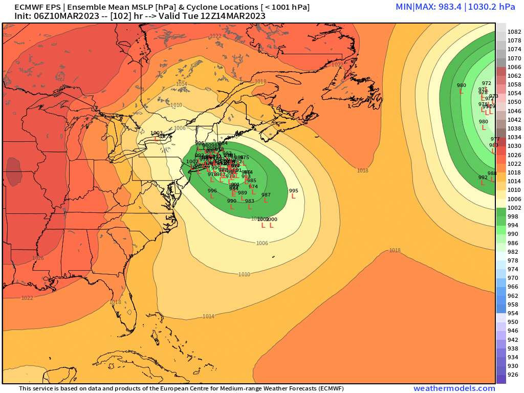
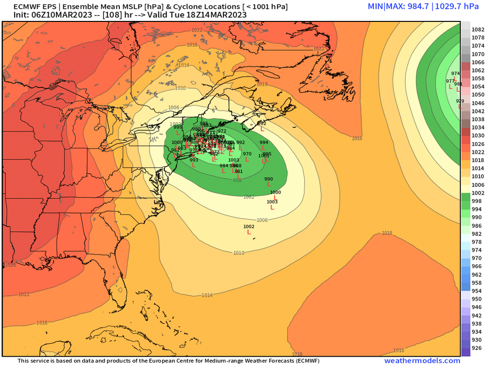
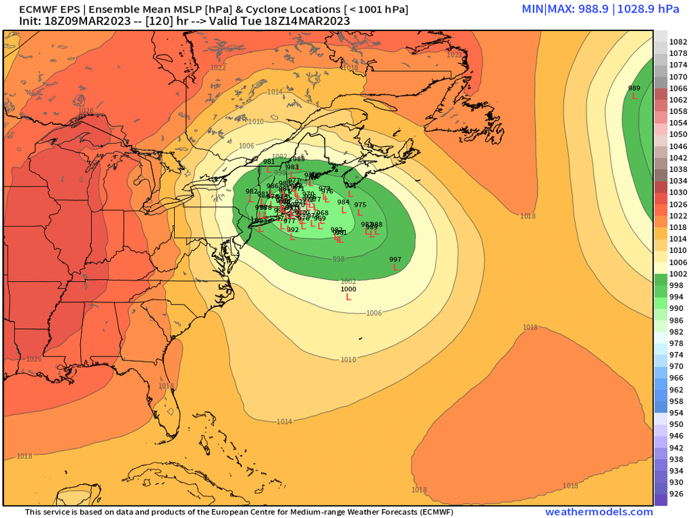
Yeah here's the 2 most relevant panels for SNE....you can see how the tightest cluster is still near that out Cape/Islands area.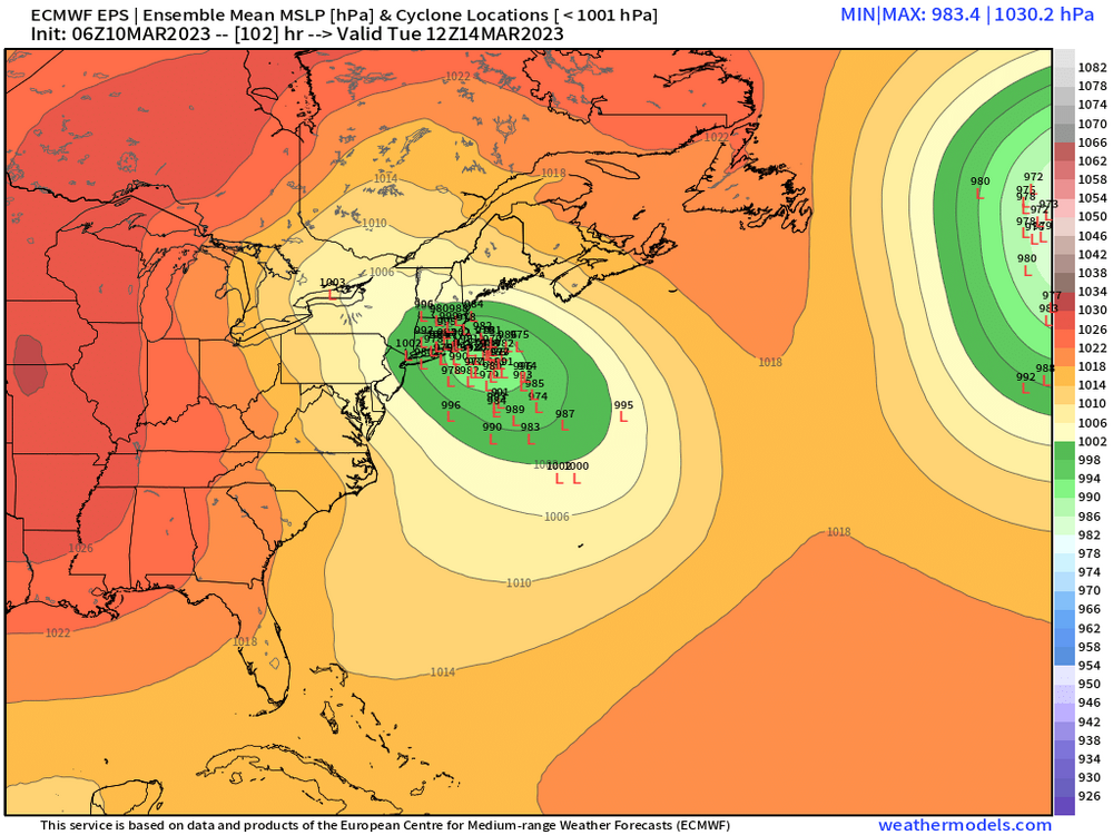
-
The last hurrah? Putting all the eggs in the Tuesday 3/14 basket
ORH_wxman replied to Ginx snewx's topic in New England
Def east of 00z but the spread increased. There’s more offshore and more inland members. The tightest cluster is still near the cape but maybe slightly east of the tightest 00z cluster. -
The last hurrah? Putting all the eggs in the Tuesday 3/14 basket
ORH_wxman replied to Ginx snewx's topic in New England
Looks like end of 06z euro run is a bit more subdued than 00z. We’ll see if that makes a difference on the ensemble run in a bit. -
The last hurrah? Putting all the eggs in the Tuesday 3/14 basket
ORH_wxman replied to Ginx snewx's topic in New England
We also don’t want that northern stream dropping in any earlier. In fact, I already think it’s dropping in too early and the only reason the euro/Ukie runs were good is because the southern stream took a wide turn. If they didn’t, this would be up the Hudson valley or CT valley. Looks like eps is putting this on the Cape/Islands still. There’s still a number of inland members…though only 2 of them are west of ORH. Most run them over BOS area and the largest cluster remains on the cape. -
The last hurrah? Putting all the eggs in the Tuesday 3/14 basket
ORH_wxman replied to Ginx snewx's topic in New England
Rgem still looks pretty ugly. I’ll bet GGEM comes in running into SNE again. -
The last hurrah? Putting all the eggs in the Tuesday 3/14 basket
ORH_wxman replied to Ginx snewx's topic in New England
It has a better look in Maine than the globals. That would’ve been really interesting if we could go out further. -
The last hurrah? Putting all the eggs in the Tuesday 3/14 basket
ORH_wxman replied to Ginx snewx's topic in New England
I think you mean 2011. -
The last hurrah? Putting all the eggs in the Tuesday 3/14 basket
ORH_wxman replied to Ginx snewx's topic in New England
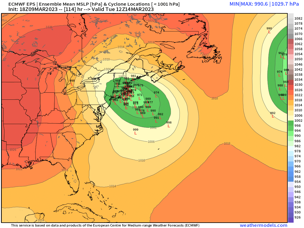
EPS lost a lot of interior lows but it has a much bigger cluster near and over the cape now.

-
The last hurrah? Putting all the eggs in the Tuesday 3/14 basket
ORH_wxman replied to Ginx snewx's topic in New England
Yes
-
March 10-11 light snow threat for SW New England.
ORH_wxman replied to Sey-Mour Snow's topic in New England
There's definite upside bust potential in W CT with that ULL. Too bad there wasn't a fresher airmass in place....prob would be talking more widespread double digit potential. -
Palisades may change to rain at 6300 feet, though it probably won't last super long as snow levels drop again later Friday....Alpine may stay all snow as snow levels prob don't rise above 7k (or if they do, it's quite brief). Still looking at 4 to 8 feet of new snow there.
-
March 10-11 light snow threat for SW New England.
ORH_wxman replied to Sey-Mour Snow's topic in New England
Upton doesn't cover Hartford county -
The last hurrah? Putting all the eggs in the Tuesday 3/14 basket
ORH_wxman replied to Ginx snewx's topic in New England
Yeah was just gonna post that it's very similar to the Euro OP. You have that leading vort focusing the low pressure there and then it gets yanked back....might not take quite as wide a turn as Euro, but the result was similar enough -
The last hurrah? Putting all the eggs in the Tuesday 3/14 basket
ORH_wxman replied to Ginx snewx's topic in New England
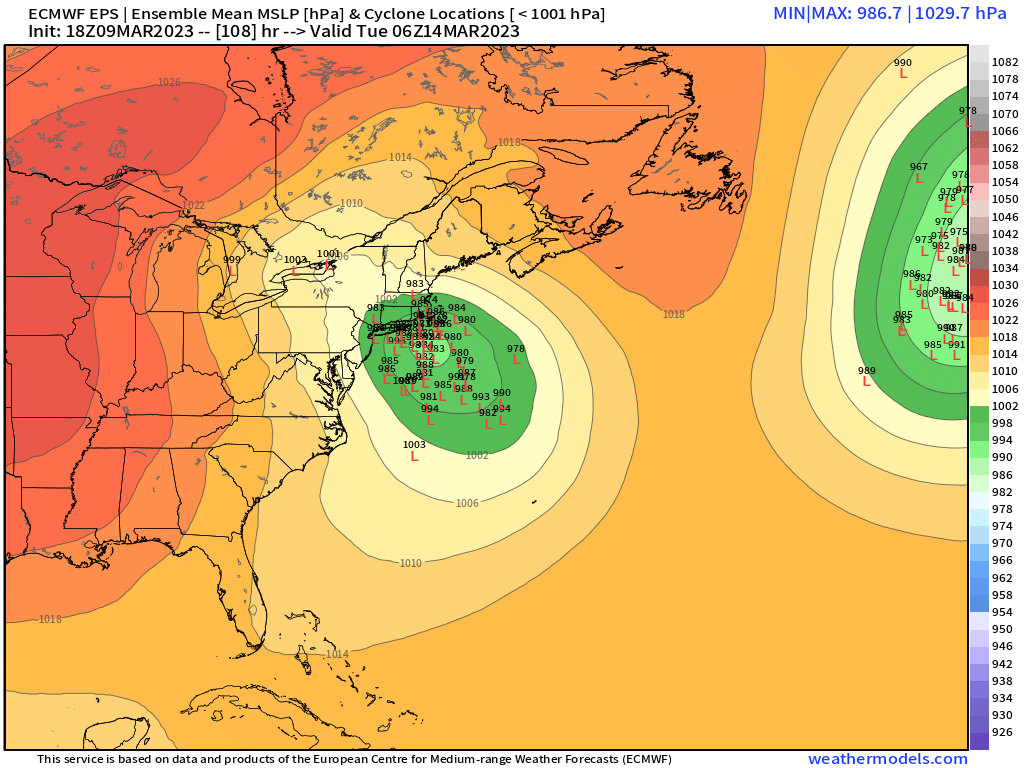
12z EPS was better than 00z. 00z took a tighter turn south of LI which made it a bit less snowy....it was 06z that was quite a bit east, but the 06z OP run only went to 90h so we never saw it's final solution. I think this is going to move around a bit though over the next few runs. -
The last hurrah? Putting all the eggs in the Tuesday 3/14 basket
ORH_wxman replied to Ginx snewx's topic in New England
Yeah I'm sure several of the ensemble members just absorb it into the northern stream early on....or don't ever really see it. I'd like to see a bit better continuity on the northern stream though...it's been jumping around a little too much for my liking on a typical D4-5 forecast. -
The last hurrah? Putting all the eggs in the Tuesday 3/14 basket
ORH_wxman replied to Ginx snewx's topic in New England
OP is probably right in the middle of the EPS....I think this makes a whiff a lot less likely now, but I never really bought the whiff idea. I've always been more concerned with ptype in this one. The key will be that lead southern streamer staying ahead of the northern stream long enough. -
The last hurrah? Putting all the eggs in the Tuesday 3/14 basket
ORH_wxman replied to Ginx snewx's topic in New England
EPS def a good bit west of 06z....a lot of inland members now which were almost completely gone at 06z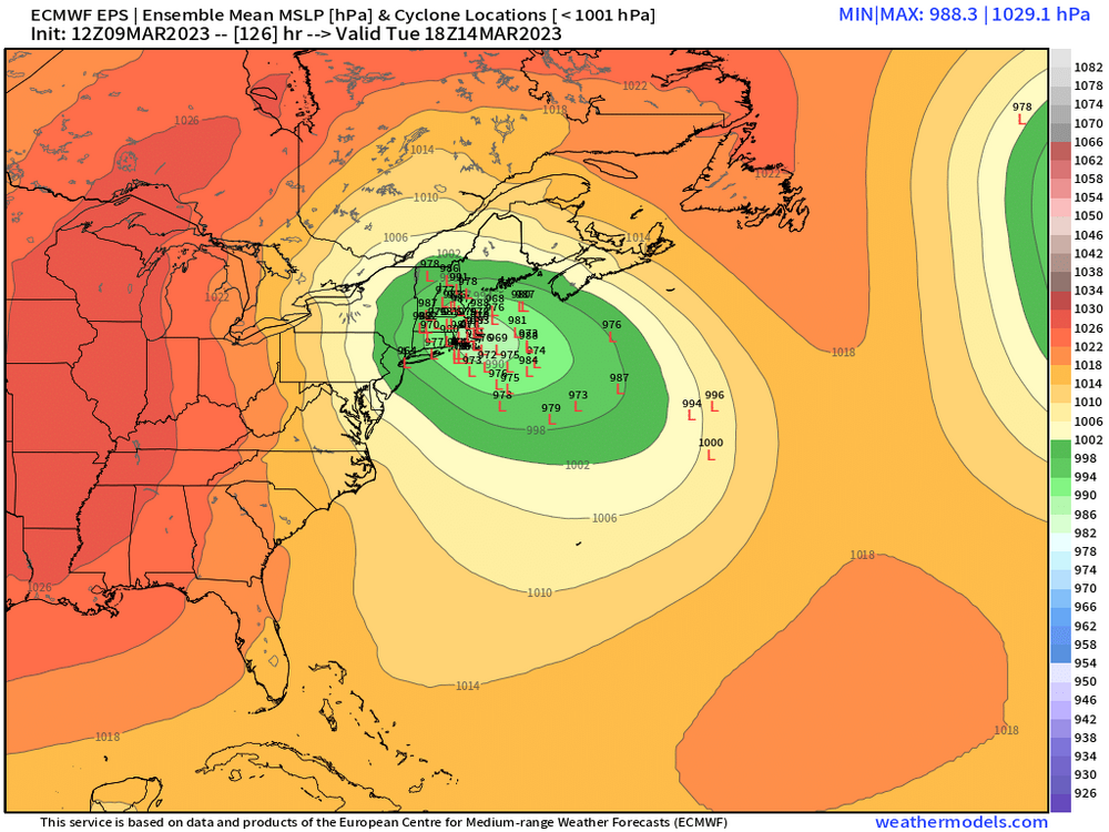
-
The last hurrah? Putting all the eggs in the Tuesday 3/14 basket
ORH_wxman replied to Ginx snewx's topic in New England
Yes it is similar to some extent, though the Jan 2015 blizzard had probably even a wider turn....another one is late Feb 1969, but again, a wider turn on that one too which is why it wasn't a big deal west of the CT river. This one is not quite going as far east initially. (or southeast in the case of Jan 2015) A little bit of 3/13/18 too. But again, this northern stream seems to be slicing in from a little more west angle which keeps better precip further west. -
The last hurrah? Putting all the eggs in the Tuesday 3/14 basket
ORH_wxman replied to Ginx snewx's topic in New England
Anytime you get legit heavy rates, it's going to latently cool the sfc to near freezing. With those rates and height falls shown on the Euro, it's going to be heavy snow under the CCB even in low elevations. If we end up with a system that produces only moderate rates, then the lower levels will definitely play a much larger role in preventing accumulations. -
The last hurrah? Putting all the eggs in the Tuesday 3/14 basket
ORH_wxman replied to Ginx snewx's topic in New England
The height falls on that run are pretty crazy....trying to tear a hole in the atmosphere near ACK/MVY. -
The last hurrah? Putting all the eggs in the Tuesday 3/14 basket
ORH_wxman replied to Ginx snewx's topic in New England
Once the CCB gets cranking, it's about -2C to -3C in the meat of it. -
The last hurrah? Putting all the eggs in the Tuesday 3/14 basket
ORH_wxman replied to Ginx snewx's topic in New England
Lower elevations would get crushed on the euro solution inside the meat of the CCB. -
The last hurrah? Putting all the eggs in the Tuesday 3/14 basket
ORH_wxman replied to Ginx snewx's topic in New England
Good animation Paul....look at that lead shortwave get pretty far east before it gets captured/phased back with the northern stream ULL...that is key to a big hit outside of the Berkshires/highest elevations.