ORH_wxman
-
Posts
93,095 -
Joined
-
Last visited
Content Type
Profiles
Blogs
Forums
American Weather
Media Demo
Store
Gallery
Everything posted by ORH_wxman
-
The last hurrah? Putting all the eggs in the Tuesday 3/14 basket
ORH_wxman replied to Ginx snewx's topic in New England
Yeah my guess is that would end up a little more subdued than 00z....we'll see what EPS says in a bit. -
The winter was pretty much a torch but did have a good arctic spell from around New Year’s Eve into the first couple days of jan ‘97 and then another short arctic punch mid month.
-
The last hurrah? Putting all the eggs in the Tuesday 3/14 basket
ORH_wxman replied to Ginx snewx's topic in New England
We’re still in the time range where OP runs are glorified ensemble members. But you can see the range of possibilities…Canadian shows what happens when it goes wrong. -
March 10-11 light snow threat for SW New England.
ORH_wxman replied to Sey-Mour Snow's topic in New England
Looks like the 18z euro was into something. You can see how much more impressive the upper air is too on some of these runs. -
The last hurrah? Putting all the eggs in the Tuesday 3/14 basket
ORH_wxman replied to Ginx snewx's topic in New England
Can we lock the icon even if it’s a weird solution?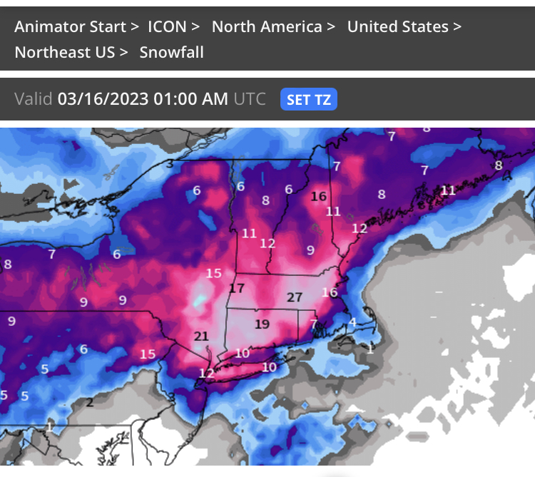
-
The last hurrah? Putting all the eggs in the Tuesday 3/14 basket
ORH_wxman replied to Ginx snewx's topic in New England
Yeah I was toggling the wrong panels. That was my bad. Sorry about that. -
Yeah if you count both Mar/Apr 1997 it was around 45”. It kind of had a similar end of the season feel to it. The pattern got a lot better in March and we got some snow events but you always felt like you should’ve had a bigger one. Then when it seemed we had wasted the chance for more (there was a blown Winter storm warning on 3/23 I think) and everyone is moving into spring, the 3/31-4/1 storm happens.
-
The last hurrah? Putting all the eggs in the Tuesday 3/14 basket
ORH_wxman replied to Ginx snewx's topic in New England
EPS looked a bit SE of 12z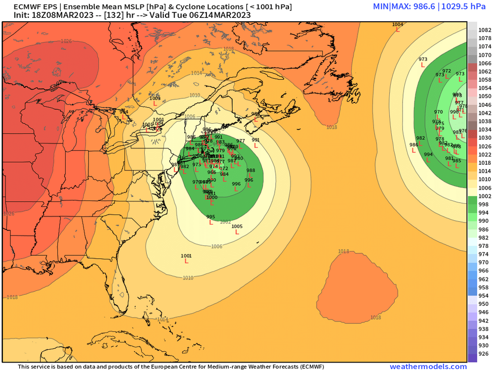
-
Lol…my secret hope has been to get like a 45” March just to screw with the seasonal numbers. But unlikely that happens now since we didn’t get hit hard enough on 3/4 and then whiffing on 3/11.
-
March 10-11 light snow threat for SW New England.
ORH_wxman replied to Sey-Mour Snow's topic in New England
That’s an interesting move by a model that typically doesn’t make big moves. We’ll see shortly if the NAM can come in with a big bump too…I’d be inclined to think it’s real if it does. -
The last hurrah? Putting all the eggs in the Tuesday 3/14 basket
ORH_wxman replied to Ginx snewx's topic in New England
Yeah that’s actually a great look there. -
The last hurrah? Putting all the eggs in the Tuesday 3/14 basket
ORH_wxman replied to Ginx snewx's topic in New England
Eh. That’s a sacred bar to jump over…it’s not impossible with this type of closed off low and stall…that makes a very high end storm plausible…but you obviously need everything to go right. If we’re seeing the stall/capture scenarios southeast of SNE in another 36 hours, then maybe it might be worth more seriously considering. -
The last hurrah? Putting all the eggs in the Tuesday 3/14 basket
ORH_wxman replied to Ginx snewx's topic in New England
It starts as rain for many. But then bombs out and flips to snow. -
The last hurrah? Putting all the eggs in the Tuesday 3/14 basket
ORH_wxman replied to Ginx snewx's topic in New England
Narcan prob a little too stingy over interior (except maybe N ORH county)....blend it with the 10 to 1. -
The last hurrah? Putting all the eggs in the Tuesday 3/14 basket
ORH_wxman replied to Ginx snewx's topic in New England
It starts at D5. -
Prob the worst I-95 NYC to DCA winter since 2001-02. BOS isn't doing much better, though they have already passed 2011-12...we'll see if they can muster up enough to get past 2019-20's putrid 15.9 inches.
-
The last hurrah? Putting all the eggs in the Tuesday 3/14 basket
ORH_wxman replied to Ginx snewx's topic in New England
So you're basically leaning MECS/HECS for a large chunk of the forum....bold call at D5, though it's certainly within the envelope of solutions. I wish there was some decent high pressure to the north though. -
Ensembles don't go out that far, but based on the end of the run, it still looks pretty blocky.
-
EPS says she's not gonna let us out.
-
The last hurrah? Putting all the eggs in the Tuesday 3/14 basket
ORH_wxman replied to Ginx snewx's topic in New England
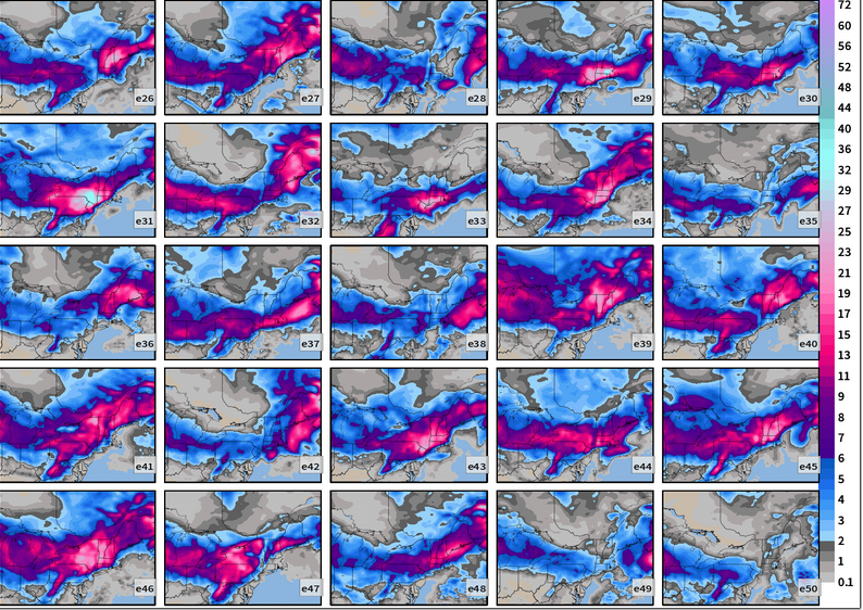
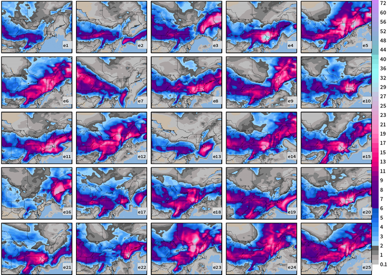
Here's a snapshot of 144h....this is when the storm on the OP was over Block Island. There seems to be a cluster near where the OP was...maybe just south of the OP....then another cluster near the outer Cape/ACK...then a lot of Buckshot outside of that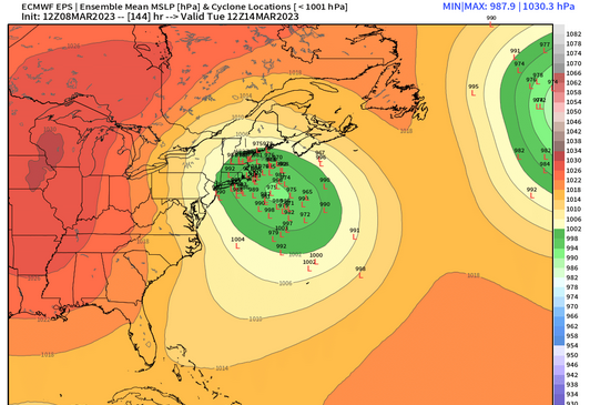
-
The last hurrah? Putting all the eggs in the Tuesday 3/14 basket
ORH_wxman replied to Ginx snewx's topic in New England
I actually forgot another one....GFS did defeat the Euro in the 2010 Boxing Day storm. That was the other major coastal it scored the coup in. Obviously different setup though. -
The last hurrah? Putting all the eggs in the Tuesday 3/14 basket
ORH_wxman replied to Ginx snewx's topic in New England
This has a northern stream diving in trying to capture a southern stream that is running out ahead of it....that's actually pretty similar to Feb 2013....only main difference is we don't have that nice area of confluence which turned that one into a monster both by locking in better cold and increasing the ML frontogenesis. But the Euro absolutely schooled most guidance on that one. Anytime you have complex interaction with two different streams, I feel like that is where the Euro shines....but I want to be careful because we're still on the edge of the Euro's wheelhouse for that sort of thing. I'd feel better if this was 24 hours closer. -
The last hurrah? Putting all the eggs in the Tuesday 3/14 basket
ORH_wxman replied to Ginx snewx's topic in New England
I think some conflate posting about a model solution with "Singing it's praise" -
The last hurrah? Putting all the eggs in the Tuesday 3/14 basket
ORH_wxman replied to Ginx snewx's topic in New England
Yes, there's def a significant (maybe 20%?) number of members that don't really produce much of a storm at all. -
The last hurrah? Putting all the eggs in the Tuesday 3/14 basket
ORH_wxman replied to Ginx snewx's topic in New England