ORH_wxman
-
Posts
93,095 -
Joined
-
Last visited
Content Type
Profiles
Blogs
Forums
American Weather
Media Demo
Store
Gallery
Everything posted by ORH_wxman
-
The last hurrah? Putting all the eggs in the Tuesday 3/14 basket
ORH_wxman replied to Ginx snewx's topic in New England
It’s gonna be another run or two to figure this out. It seems like the trend has been for guidance to try and do the IVT elongated low but then it eventually decides it wants the southern stream one to take over…I’m hoping we see a little earlier on that consolidation. -
The last hurrah? Putting all the eggs in the Tuesday 3/14 basket
ORH_wxman replied to Ginx snewx's topic in New England
Rgem was run from ginxy’s basement -
The last hurrah? Putting all the eggs in the Tuesday 3/14 basket
ORH_wxman replied to Ginx snewx's topic in New England
Wound be almost perfect if we could get that upper low about another 50-100 miles SE. -
The last hurrah? Putting all the eggs in the Tuesday 3/14 basket
ORH_wxman replied to Ginx snewx's topic in New England
Interior looks pretty good as long as we avoid the furthest west members. We’d prob get crushed on all those buzzards bay to cape cod bay members…your area def wants that cluster east of the elbow. -
The last hurrah? Putting all the eggs in the Tuesday 3/14 basket
ORH_wxman replied to Ginx snewx's topic in New England
Nice clusters
-
The last hurrah? Putting all the eggs in the Tuesday 3/14 basket
ORH_wxman replied to Ginx snewx's topic in New England
The 06z run gave ORH 20” in 9 hours. Lol -
The last hurrah? Putting all the eggs in the Tuesday 3/14 basket
ORH_wxman replied to Ginx snewx's topic in New England
The southern stream vort cluster comes onshore around 12z today in CA so we’ll see if there’s any notable shifts that start on this next run. -
The last hurrah? Putting all the eggs in the Tuesday 3/14 basket
ORH_wxman replied to Ginx snewx's topic in New England
Winter hill scorpion bowl party that run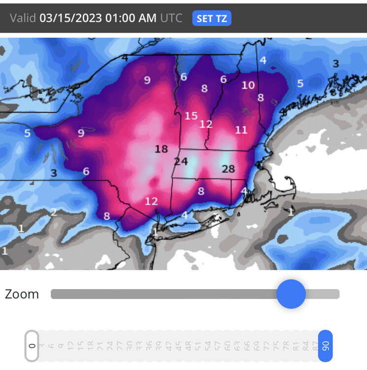
-
The last hurrah? Putting all the eggs in the Tuesday 3/14 basket
ORH_wxman replied to Ginx snewx's topic in New England
I’m loving seeing those midlevels close off and get going south of us. That’s a bullish sign tonight. -
The last hurrah? Putting all the eggs in the Tuesday 3/14 basket
ORH_wxman replied to Ginx snewx's topic in New England
Crushage. Details still TBD but that was a very good 00z suite. If we can repeat something similar at 12z, then I may start honking. -
The last hurrah? Putting all the eggs in the Tuesday 3/14 basket
ORH_wxman replied to Ginx snewx's topic in New England
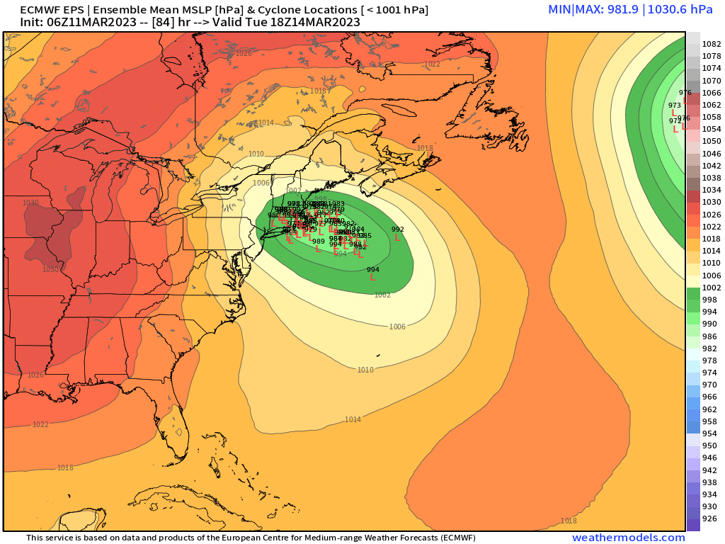
Correct. If the upper low wasn’t elongated when it goes south of us, it would tuck everything in closer and the flow in the MLs would be more SE and that’s going to be useless. The elongated low keeps that baroclinic zone further south (and east). -
The last hurrah? Putting all the eggs in the Tuesday 3/14 basket
ORH_wxman replied to Ginx snewx's topic in New England
Yeah maybe…certainly close. Something like the NAM just a little further south would be pretty epic too. Essentially what you’re going for if we’re trying for the unicorn is to get that midlevel flow out of the east before it warms above 0C and at the same time we’re turning the lower levels more NE with a stall somewhere south of the islands. You need an entirely closed upper level going underneath LI elongated east-west. -
March 10-11 light snow threat for SW New England.
ORH_wxman replied to Sey-Mour Snow's topic in New England
Still quite a bit of heavy precip streaming north. Hopefully some of you can flip and grab a few inches of paste
-
The last hurrah? Putting all the eggs in the Tuesday 3/14 basket
ORH_wxman replied to Ginx snewx's topic in New England
Ukie came east a good bit…but not a surprise after 12z’s adventures into Tolland. Ukie is dumping like 4” of QPF on WaWa and berks…lol. Prob mostly snow. -
The last hurrah? Putting all the eggs in the Tuesday 3/14 basket
ORH_wxman replied to Ginx snewx's topic in New England
You guys look at clown maps way too much. The GGEM was about as classic as it gets for a pretty widespread heavy snow impact. The H5 was awesome, the midlevels were awesome. I certainly wouldn’t trust the GGEM’s lowest level thermals…prob one of the worst models for that (long with Ukie) -
The last hurrah? Putting all the eggs in the Tuesday 3/14 basket
ORH_wxman replied to Ginx snewx's topic in New England
Yeah. Might be a little less in SE areas as BL is pretty marginal for a long time. But from a higher view, the GGEM has all the right stuff for a widespread hit…closes off everything south of us and rips back some great fronto in the CCB. -
The last hurrah? Putting all the eggs in the Tuesday 3/14 basket
ORH_wxman replied to Ginx snewx's topic in New England
That’s an epic GGEM solution. Closes off everything well south of SNE. -
The last hurrah? Putting all the eggs in the Tuesday 3/14 basket
ORH_wxman replied to Ginx snewx's topic in New England
Nice large area of 2 feet for CT that run -
The last hurrah? Putting all the eggs in the Tuesday 3/14 basket
ORH_wxman replied to Ginx snewx's topic in New England
Congrats buried bodies on the icon -
The last hurrah? Putting all the eggs in the Tuesday 3/14 basket
ORH_wxman replied to Ginx snewx's topic in New England
That’s the first run it’s keeping the low east of GON…pretty snowy for interior. -
The last hurrah? Putting all the eggs in the Tuesday 3/14 basket
ORH_wxman replied to Ginx snewx's topic in New England
Yeah not really buying it. More just entertaining fodder before the real models come out. It does highlight some of the model guidance uncertainty though. We keep getting different variations of this storm. -
The last hurrah? Putting all the eggs in the Tuesday 3/14 basket
ORH_wxman replied to Ginx snewx's topic in New England
Eventually it would but it’s prob going to redevelop somewhere out east when that intense vortmax down in VA keeps pressing eastward. Dec ‘92 did that too…initially captured near Delmarva but then redeveloped east and pinwheeled up to a position south of MVY where it rotted for a bit before finally drifting off E or ESE. -
The last hurrah? Putting all the eggs in the Tuesday 3/14 basket
ORH_wxman replied to Ginx snewx's topic in New England
It’s not snowing due east of the low…maybe northeast of the low but that is fairly normal as long as you are north of the midlevel warm front which is pretty clear in this run… -
The last hurrah? Putting all the eggs in the Tuesday 3/14 basket
ORH_wxman replied to Ginx snewx's topic in New England
I mean, if we start capturing this off the coast of SE NJ, then all of the sudden the parallels become a bit more striking. When we’re flinging the low way east before capture, it wasn’t all that similar…but if you start capturing down there and driving the ULL into MD or VA, then you quickly have a different beast. -
The last hurrah? Putting all the eggs in the Tuesday 3/14 basket
ORH_wxman replied to Ginx snewx's topic in New England
Lol NAM trying to pull a Dec ‘92 there…capturing the low way down south there.