ORH_wxman
-
Posts
93,095 -
Joined
-
Last visited
Content Type
Profiles
Blogs
Forums
American Weather
Media Demo
Store
Gallery
Everything posted by ORH_wxman
-
The last hurrah? Putting all the eggs in the Tuesday 3/14 basket
ORH_wxman replied to Ginx snewx's topic in New England
The cliff's note version on that storm was the GFS won in the medium range (like D3-5) and the Euro won inside of 48h. -
The last hurrah? Putting all the eggs in the Tuesday 3/14 basket
ORH_wxman replied to Ginx snewx's topic in New England
I haven't seen the GFS defeat the Euro yet on a significant coastal storm for us since it was the AVN model when it scored a coup in the 12/30/00 storm. Even when the Euro barfed in that run with giving NYC 30" in the Jan 2015 storm...it was like 50 miles too far west....but the GFS was still scraping ORH with like an inch of QPF....lol. GFS has really seemed to close the gap on the Euro in non-coastals. -
The last hurrah? Putting all the eggs in the Tuesday 3/14 basket
ORH_wxman replied to Ginx snewx's topic in New England
EPS hooks and stalls this east of ACK....that would make the AEMATT crowd very happy. -
The last hurrah? Putting all the eggs in the Tuesday 3/14 basket
ORH_wxman replied to Ginx snewx's topic in New England
Yeah my view is that those BL temps won't take away a truly great storm...they might take away a run-of-the-mill warning event though. But truly great storms nuke 2" per hour rates for hours on end....run-of-the-mill warning events often do not...or if they do, it's not for very long. So if we're sitting here putting 0.05" in the bucket every hour cursing at 34F white rain, my view is that we weren't missing out on anything epic to begin with. Yeah, I'd rather have 6-7" of paste than 2" of slop, but I won't lose a ton of sleep over it. At this point in a shitty season, I'm kind of on the big dog or bust train....give me 1.5-2 inches of QPF in 12 hours and I'd take my chances with -1C 925 temps. -
The last hurrah? Putting all the eggs in the Tuesday 3/14 basket
ORH_wxman replied to Ginx snewx's topic in New England
I view this as "if you are struggling at 33-34F light/mod snow, then it wasn't ever going to be great anyway"....maybe 6-7" paster becomes 2-3" slop storm, but the lowest 1,000 feet probably isn't going to be the difference between an 18" storm and a 4" storm. Maybe it's a 12-14" deck collapser instead of 18-20". This is assuming that the mid-levels down to 925mb are a snow profile. -
The last hurrah? Putting all the eggs in the Tuesday 3/14 basket
ORH_wxman replied to Ginx snewx's topic in New England
Or even 925mb like in the 12/16 event. I really like to look at 925mb...esp in late season events...that was a big failure in a lot of forecasts in the Feb 24, 2010 interior storm (just before the retrostorm that dumped rain) and in the March 2013 firehose storm. 2013 was more egregious because 925 temps were like -5C and everyone was forecasting mostly rain or non-accumulating snow. 2010 was a little trickier, but that one had like -1C 925 temps over the interior and ORH hills got crushed with like 1-2 feet when most outlets were forecasting 2-4 inches. -
The last hurrah? Putting all the eggs in the Tuesday 3/14 basket
ORH_wxman replied to Ginx snewx's topic in New England
Keep in mind, wherever you are putting 0.75-1.00 in the bucket on 6 hourly QPF, it's going to be rapidly accumulating snow wherever the profile supports snow. The marginal airmass will matter more when it's lighter. During that CCB that's dropping 2" of QPF over ORH in 12 hours, you aren't going to have many thermal issues....but in the parts where you get like 0.04 per hour stuff, that's when the relatively milder BL and elevation comes more into play. -
The last hurrah? Putting all the eggs in the Tuesday 3/14 basket
ORH_wxman replied to Ginx snewx's topic in New England
Yeah I'd think closer to like 8-10" here rather than the 15 on the 10 to 1 maps...and then 12-18 for ORH county to outside 495, though probably 20 burgers in the elevations above 800-1000 feet. They'd clean up big time....Winter Hill scorpion bowls. -
The last hurrah? Putting all the eggs in the Tuesday 3/14 basket
ORH_wxman replied to Ginx snewx's topic in New England
Looks like it's pretty damned good outside of 495. -
The last hurrah? Putting all the eggs in the Tuesday 3/14 basket
ORH_wxman replied to Ginx snewx's topic in New England
Northern stream is also solidly southeast of the 00z position by 96h. -
The last hurrah? Putting all the eggs in the Tuesday 3/14 basket
ORH_wxman replied to Ginx snewx's topic in New England
It's still early (84h), but the 12z run looks more progressive with the main shortwave....so my guess is this solution will likely be east of 00z....but lets see if there are other factors that counter that. -
The last hurrah? Putting all the eggs in the Tuesday 3/14 basket
ORH_wxman replied to Ginx snewx's topic in New England
Yeah we should prob stress that in a blocky flow, model guidance could easily change the look enough to matter a lot for sensible wx. -
The last hurrah? Putting all the eggs in the Tuesday 3/14 basket
ORH_wxman replied to Ginx snewx's topic in New England
Ironically, Saturday's system would have made a good infusion to the 50/50 vortex, but it's getting crushed so far ESE it never helps out. We're left with the naked trailing ridge behind it with less 50/50 now pressing the heights down in Quebec. In addition, the better Pacific with the big rockies ridge is actually making the northern stream dig a little too much for my liking on some of these solutions. We want it to dig, but not as early as it's doing, but it's responding to the big ridge building out west. All of that in combination is making this more of a needle-threader than you'd typically want to see. There's still pretty high potential in this system, but I don't see a lot of margin for error that we sometimes see in other big dogs. -
The last hurrah? Putting all the eggs in the Tuesday 3/14 basket
ORH_wxman replied to Ginx snewx's topic in New England
If that lead vortmax isn't the center of focus, then this will be mostly a rain event for a lot of New England...the northern stream diving in is pretty far west....further west than you'd typically want to see. If there was confluence out ahead of it like Feb 2013, then it wouldn't matter as much, but since we don't have that, this setup is a lot more precarious than I think most in here are currently acknowledging. -
The last hurrah? Putting all the eggs in the Tuesday 3/14 basket
ORH_wxman replied to Ginx snewx's topic in New England
Synoptics are bad on that run too...so even though Ukie often has a warm bias in the thermals, in this case, it would suck for most outside of interior hills of NNE. -
The last hurrah? Putting all the eggs in the Tuesday 3/14 basket
ORH_wxman replied to Ginx snewx's topic in New England
Ukie is too far north with the ULL while at the same time being pretty weak with that southern stream which floods a lot of warmer air into the region...not a very snowy look until you get into the interior of NNE. -
The last hurrah? Putting all the eggs in the Tuesday 3/14 basket
ORH_wxman replied to Ginx snewx's topic in New England
No good high to hold in the airmass....which is ok...I wouldn't call it all that cold., but good enough. On the GGEM, the 925 temps start off around -4C to -5C over SNE....during the CCB, they have warmed to -2C or so...and it's definitely not an inverted airmass where the low levels are much colder than aloft. -
The last hurrah? Putting all the eggs in the Tuesday 3/14 basket
ORH_wxman replied to Ginx snewx's topic in New England
I am much more concerned about ptype in this system than a whiff....GFS is classic SE on these partial phase scenarios. Notice how all other guidance continues to slowly amp up (sans the Euro which was so zonked yesterday, it has come a little SE) -
The last hurrah? Putting all the eggs in the Tuesday 3/14 basket
ORH_wxman replied to Ginx snewx's topic in New England
I ran that one form my basement -
March 10-11 light snow threat for SW New England.
ORH_wxman replied to Sey-Mour Snow's topic in New England
Amazing how much the GFS trended south in the past 36-48h....got it's ass totally whipped by the Euro in this one from D4ish unlike the last event. This is why we don't de-emphasize the Euro too much...esp when it's not totally on an island. -
The last hurrah? Putting all the eggs in the Tuesday 3/14 basket
ORH_wxman replied to Ginx snewx's topic in New England
Gonna need to see some larger changes IMHO to get a widespread hit like a Feb '13....the synoptics are pretty ugly for the CP, whereas in Feb '13 they weren't. That's why that storm had like 18" of paste east of the CF and 30" west. Anyone to the east of a hypothetical CF in this storm is raining. Best bet for a widespread hit is to get something that starts off as snow over interior and then as the storm bombs over or east of a place like ACK, it flips the CP to paste and they get croaked. -
The last hurrah? Putting all the eggs in the Tuesday 3/14 basket
ORH_wxman replied to Ginx snewx's topic in New England
I just checked it, seems ok to me? What issue were you having? -
March 10-11 light snow threat for SW New England.
ORH_wxman replied to Sey-Mour Snow's topic in New England
DXR special....those hills just north of the Merritt in SW CT might do ok. Hopefully the shortwave comes in a bit better today....though the 12z NAM didn't really give any confidence to that happening...looked worse than the 06z run. -
The last hurrah? Putting all the eggs in the Tuesday 3/14 basket
ORH_wxman replied to Ginx snewx's topic in New England
I’d like to see the ULL center further southeast. Sitting there in between Lake Erie and Huron isn’t ideal for coastal plain folks…caveat is that you have that leading vortmax become strong enough to really render the western ULL irrelevant…but in those scenarios I don’t think you’d get the classic capture until well later. -
The last hurrah? Putting all the eggs in the Tuesday 3/14 basket
ORH_wxman replied to Ginx snewx's topic in New England
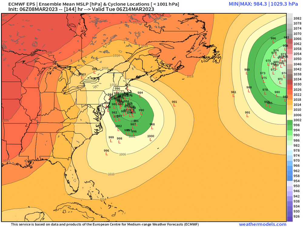
EPS has been pretty consistent considering the lead time.