ORH_wxman
-
Posts
93,095 -
Joined
-
Last visited
Content Type
Profiles
Blogs
Forums
American Weather
Media Demo
Store
Gallery
Everything posted by ORH_wxman
-
The last hurrah? Putting all the eggs in the Tuesday 3/14 basket
ORH_wxman replied to Ginx snewx's topic in New England
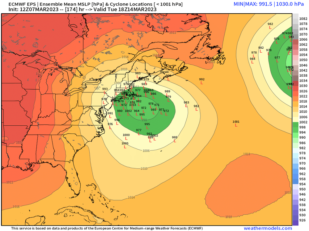
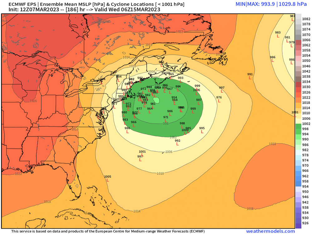
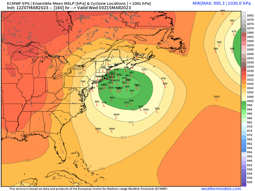
This could still track anywhere but I do like the interior zones at the moment. Not a good high pressure setup for the coast. Though once it nukes out the snow line would prob collapse SE to the coast on a favorable track…we’ll see what today brings. -
Funny thing is this thread could still deliver…even if it’s next week. The original threat was a large index scale signal, and it just happens the second shortwave in the flow is perhaps better aligned for the major storm than the first one (hence the 10-15th for a date range)
-
18z euro tickled south…that one is mostly dead imho. Type of threat that really can’t afford any setbacks. Maybe 00z is last gasp for the southern crew to see if it can inch north.
-
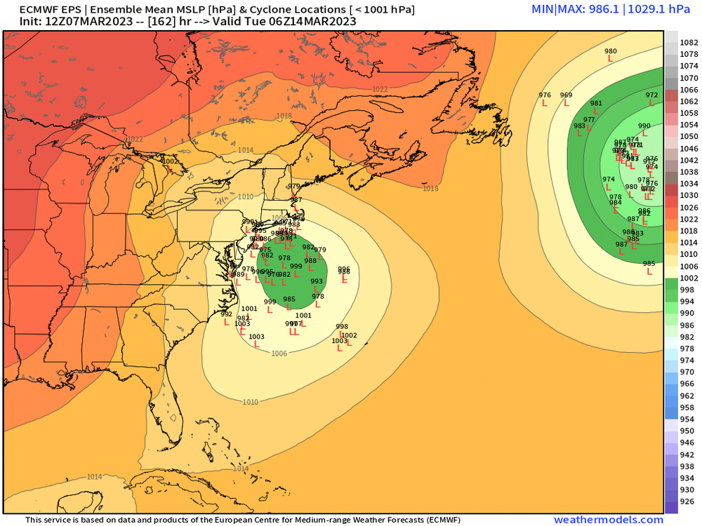
EPS individual lows….very slow moving too. Too bad it’s prob not the final solution but someone will prob get crushed on this whether it’s NNE/NY state or further south.

-
I also try and look at which models are leading the way. The Euro has been suppressed for several cycles now and the GFS has consistently trended south in the past 4-6 runs compared to when it was bringing the low into SNE. In the March 3-4 storm, it was the GFS which was holding mostly steady (until finally inching north inside of 48h) while the euro was consistently trending south from almost a cutter solution (or really late redeveloper). So it’s easy for me to put more weight on the euro solution for this Saturday’s storm than the previous one at d4 when it looked like it was playing catch-up. Doesn’t mean this one will definitely miss, but it feels like it has a better handle this time.
-
But you can’t toss the euro like you’ve said a few times. It still should get more weight than other guidance. Just not like 80/20 anymore. Id give it less weight if it was on an island (like it was in the D4 lead time to 3/4) but in the example of this Saturday, it is not on an island. It is suppressed like other guidance is. GFS is furthest north.
-
And I should caveat, there’s a long way to go on that system. ULL placement has been jumping quite a bit. At least there’s something to track…but I don’t think people should expect it to be snowy. There’s plenty of ways it doesn’t snow on that.
-
You don’t generally want a strong ULL over Lake Huron. It interferes with where you want any semblance of high pressure resistance to help put. You either want something well NW like over James bay or have it much further southeast like over PA. You can get a decent track with the ULL over Lake Huron, but those are the types of runs where it scours our all the cold. You have a southerly flow in Quebec in response to it so there’s basically no ageo drain until the main storm is really close…which by that time, your cold source has been exhausted and scoured out.
-
You prob wouldn’t be punting this so easily if you were in CT or equivalent latitude. Next week definitely has more pacific support but it could also end up running west of us too.
-
I dunno man…that block isn’t some weak entity. It wouldn’t take much weakening for the storm to be a solid hit, but I don’t see why we should expect it to weaken on future runs…it might weaken, but I think it is just as likely it could come in stronger.
-
Yeah it does. Confluence just crushes it. There’s probably a non-linear response to this though if confluence comes in a little weaker on future runs. You can see how close synoptically it is to a very good storm.
-
Don’t love the confluence. But the ULL is quite a bit more potent in the lakes
-
Saturday is def not looking great but non-GFS suite trends were north at 12z. So I wouldn’t write it off yet. But it’s the type of system you want to see another bump north at 00z. Can’t afford any negative trends. Also pending the euro. If that model doesn’t look any better at 12z, it makes it more of a long shot. Despite it not dominating like it used to, it’s still a top tier model.
-
Well I said we needed some positive trends at 12z and so far we’ve gotten that. We’ll see what the Ukie/euro do but so far it’s been a little better. I do like seeing the ULL pretty far north near CLE/ERI…even more toward BUF on the GFS. Usually it’s hard to whiff us south when you get the ULL that far north.
-
GGEM looks quite a bit north this run.
-
Yeah it was def south through about 72h but it’s made up ground
-
Yeah I may be wrong lol. Stronger shortwave May overcome it.
-
GFS is going to continue to go south this run for Saturday.
-
He knows it is disingenuous. He doesn’t care. Anyone with any modicum of meteorology knowledge knows the pattern has been quite different since about 2/23. There’s a reason CNE/NNE has gone gangbusters in that period and there’s actually been some snow events in SNE as well with potential for more.
-
Gonna need some positive trends at 12z imho for Saturday to be a legit threat.
-
2-3 days apart isn’t that weird at all. Esp for March with those blockier patterns and shorter wavelengths. Now if they were 24 hours apart it would be much harder.
-
Nice western ridge on that one.
-
Keep this thread clean and on topic. This is an actual storm thread....we have a banter thread
-
Lets get a 3/29/84 redux
-
I also think there's two issues that I wasn't clear on above....the trend out west got better on all the guidance. We saw more wave spacing than on the 00z runs. However, some of the guidance like the Euro and GGEM got blockier out east which shunted the system south of us so we weren't able to take advantage of the better trends out west for the 3/11 threat.