ORH_wxman
-
Posts
93,098 -
Joined
-
Last visited
Content Type
Profiles
Blogs
Forums
American Weather
Media Demo
Store
Gallery
Everything posted by ORH_wxman
-
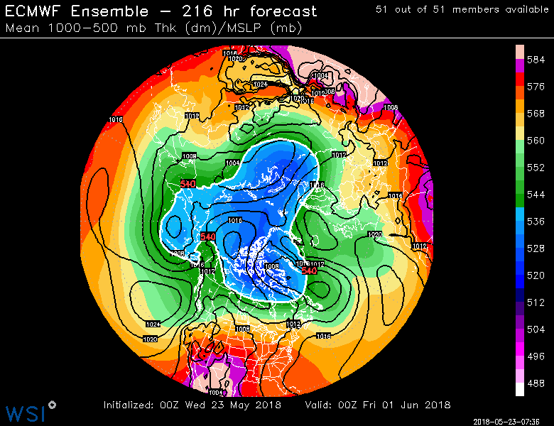
Yeah recently, it's been colder over the arctic versus the first week of the month. There looks to be a dipole still trying to set up as we head into June, but the sig is def weaker than it was a few days ago on the Euro ensembles....it shows more low pressure poking up from the CAA and also hanging back down from the Kara to try and go over the pole. It still has the general low pressure over the Kara area and the general high pressure over the Beaufort, but the high is covering less area than before. If we end up with some low pressure over the pole with a smaller high over the Beaufort, then the sensible wx impact of the pattern will be greatly diminished versus a true dipole blocking pattern. For bigger impact, I want to see that high sprawl to the east toward Greenland the low pressure over the Kara shift a little more toward the Barents....really start churning that fram export and also help the wind come more off Siberia.
-
We don't have good real time meltponding data unfortunately. We'll prob have to wait until early June when Schroeder gives an update (he's the guy who authored the original paper in 2014 on melt ponding). The month stated off warm in the arctic, but the melt ponds typically don't get going until later in the month in the peripheral areas....and the past 7-14 days have not been very warm in the peripheral areas like the Kara, Laptev or the Beaufort where it's been an ice box. The Chukchi has been the exception...so that might be where to watch. The Laptev may try and get a good shot of warmth this week over the next few days.
-
Euro ensembles are showing a classic dipole pattern setting up in early June...low pressure over Kara/Laptev region with high pressure over the Beaufort and CAA. If that verifies, we would have a good jump start to the melt season in June for the first time in years.
-
Yep...I'm def a bit more interested in what happens late this month and into early June...that's when the meltpond formation starts ramping up a lot. The total meltpond formation in May does have a good correlation, but a lot of that occurs in the final week to 10 days of the month. If we can sustain the warmer pattern into late May, then it will definitely help...even if we have a flip in June. 2016 saw a very warm May (warmer than 2011 and 2012) but it flipped in June back to just slightly above normal temps and it likely cost us a run at the record...but that May still helped with getting momentum into the season and we finished with a top 3 lowest min. It probably helped too that 2016 was the warmest refreeze season on record up there. It was nearly 2C warmer than 2015 (Oct-Apr area-weighted average)...and we've sustained the warmth into the next two winters, though this past winter wasn't quite as warm...it was about half a degree C cooler than 2016, but still warmer than all previous ones before 2016 and 2017.
-
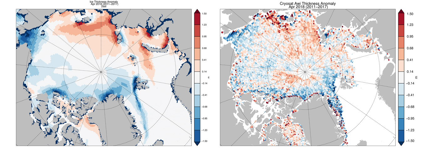
Got a long ways to go before anything becomes too exciting....it's going to come down to weather if you are looking for a record minimum. It's gonna take a massive warm dipole to probably get there given the distribution of ice thickness this winter. Gonna want something that looks kind of like the 2007 pattern....you can see how the thicker ice is all in the Laptev and East Siberian seas.

-
March 12/13/14 Blizzard/Winter Storm/WWA etc
ORH_wxman replied to Bostonseminole's topic in New England
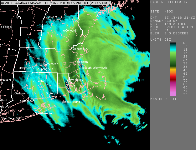
This was the radar when Ray cleared....he cleared at the 5pm mark, and this is probably about 3-4 inches per hour type snow over him at the time so it was definitely a perfect time to clear to optimize high totals....
-
March 12/13/14 Blizzard/Winter Storm/WWA etc
ORH_wxman replied to Bostonseminole's topic in New England
Hey for all the flak PeteB takes by some on here...he knows his snowfall measuring -
March 12/13/14 Blizzard/Winter Storm/WWA etc
ORH_wxman replied to Bostonseminole's topic in New England
Why does he think the melted core is accurate? That isn't credible. -
March 12/13/14 Blizzard/Winter Storm/WWA etc
ORH_wxman replied to Bostonseminole's topic in New England
Or he cut a biscuit into existing snowpack from that paste bomb last week....that might do it. -
March 12/13/14 Blizzard/Winter Storm/WWA etc
ORH_wxman replied to Bostonseminole's topic in New England
I mean, he prob didn't do it on purpose....but it's clearly an error. Maybe he cut a biscuit where a snow avalanche off the roof happened so he was slicing through packed snow or something. There is a zero percent chance he had like 7 to 1 ratios up there. -
March 12/13/14 Blizzard/Winter Storm/WWA etc
ORH_wxman replied to Bostonseminole's topic in New England
The 3+ qpf report is about 100x more egregious than a snowfall report that was about 6 inches higher. That 3+ qpf is so blatantly not credible. -
March 12/13/14 Blizzard/Winter Storm/WWA etc
ORH_wxman replied to Bostonseminole's topic in New England
Airports have 6 hour measurements going back to the 1940s even...though not all of them did. The 6 hour clearing method will probably be more accurate in the long run than a coop who only sticks a ruler in the ground at 7am every morning. You lose way too much snow in the latter. Most NWS people I have talked to don't enforce the changes because they are pretty subjective and sometimes impractical. Besides, there is the subjective element of "when instructed"...and the NWS people can just say they instruct them to continue measuring with 6 hour increments. What is the point now of having a homogeneous record broken if someone has been measuring snow for a decade using the clearing method? Only in storms that have a big fluff band will the differences be really obvious anyway. -
March 12/13/14 Blizzard/Winter Storm/WWA etc
ORH_wxman replied to Bostonseminole's topic in New England
Snow pack is extra impressive looking because we still had all that low ratio cement from the previous storm last week before yesterday happened....so while 2 feet of snow looks impressive no matter what, the piles and everything are starting to give me flashbacks to 2015. -
March 12/13/14 Blizzard/Winter Storm/WWA etc
ORH_wxman replied to Bostonseminole's topic in New England
You would think so....but the 2nd half of March can shut down quickly sometimes even when things look pretty good for more threats like they do now. Climo would get them there, that's for sure. -
March 12/13/14 Blizzard/Winter Storm/WWA etc
ORH_wxman replied to Bostonseminole's topic in New England
Anything under 15 to 1 up in that area that was also measured last night isn't credible IMHO. That band was blower powder. You need to be either outside the band with crappier snow growth or right on the beach where the snow stayed pretty wet to have ratios under 15 to 1. I can buy it maybe if you didn't measure until morning. Given the nature of the snow in that band...if you were swiping every 6 hours, your total is def going to contrast more with the "yardstick in the ground at the end" method more than normal. In a typical dry cement windblown blizzard, the difference might only be 3 inches. It could very well be double that in a storm like yesterday if you were being very diligent. -
March 12/13/14 Blizzard/Winter Storm/WWA etc
ORH_wxman replied to Bostonseminole's topic in New England
I'll add to the list for ORH.... 21.8" yesterday was a daily record, but it also put the monthly total at 40.0".....this is the 2nd snowiest March on record for ORH only behind March 1993 which saw 44.1". -
March 12/13/14 Blizzard/Winter Storm/WWA etc
ORH_wxman replied to Bostonseminole's topic in New England
Yeah every once in awhile Norfolk will get like a 6 inch blitz on upslope and you're like "WTF did that come from?" while its partly sunny 10-15 miles east. -
March 12/13/14 Blizzard/Winter Storm/WWA etc
ORH_wxman replied to Bostonseminole's topic in New England
Towns that have their own local power company seem to fair way better than the larger companies in avoiding outages or getting power back much faster when they do occur. -
March 12/13/14 Blizzard/Winter Storm/WWA etc
ORH_wxman replied to Bostonseminole's topic in New England
The type of snow in that death band was blower...like LES almost. 20 to 1 or 25 to 1 stuff. So the swipers and the "yardstick in the ground at the end" measurements are going to have more disparity than usual. If the snow had much crappier ratios, then the differences would be pretty minor. -
March 12/13/14 Blizzard/Winter Storm/WWA etc
ORH_wxman replied to Bostonseminole's topic in New England
I know Sam mentioned the squalls tomorrow afternoon, but don't sleep on a bit of snow too in the evening/night as well tomorrow night with the deepening of the ULL just as it passes our longitude, almost wants to throw an IVT back, so there could be some currier and ives stuff that blossoms. Doubt it will be a big deal, but if someone gets an inch or so it wouldn't be shocking. -
March 12/13/14 Blizzard/Winter Storm/WWA etc
ORH_wxman replied to Bostonseminole's topic in New England
You can update measurements however frequently you'd like, but you can't wipe the board clean more than once every 6 hours. When you wipe the board, you must take note of the depth on the board before you clean it. -
March 12/13/14 Blizzard/Winter Storm/WWA etc
ORH_wxman replied to Bostonseminole's topic in New England
Yeah that was the winter....2009-2010. It still gives a lot of people PTSD about a -NAO despite what happened the next winter with a strong -NAO....then 2013 and now this March. Ill say to wiz, confluence isn't a bad thing. It's only bad when it's so strong we get whiffed. But confluence helps with frontogenesis so you can wring out extra precip too...and on would-be rainers, it can force them underneath us for snow instead. -
March 12/13/14 Blizzard/Winter Storm/WWA etc
ORH_wxman replied to Bostonseminole's topic in New England
Yeah it was all about the midlevels. Same theme (different setup though) in march 2013 with the surface low way east but the midlevels were throwing forcing wayyy west into SNE. -
March 12/13/14 Blizzard/Winter Storm/WWA etc
ORH_wxman replied to Bostonseminole's topic in New England
About 2 feet in Holliston...finally cleared out deck and driveway and ready to go on a drive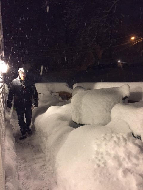
-
March 12/13/14 Blizzard/Winter Storm/WWA etc
ORH_wxman replied to Bostonseminole's topic in New England
Band is slowly moving east....but another slow moving band over ORH is migrating as well.