tiger_deF
-
Posts
615 -
Joined
-
Last visited
Content Type
Profiles
Blogs
Forums
American Weather
Media Demo
Store
Gallery
Everything posted by tiger_deF
-
What would be more satisfying to the board; to see solutions converge West and more intense after staying relatively weaker and more Eastern, or to see the same strong, intense storm modelled with only small wobbles up until the start time?
-
Friendship ended with 12z suite (outside of NAM), now 18z suite is my best friend
-
The ICON supercomputer? I was expecting the ICON room-sized vacuum tube computer
-
I think the upcoming 12z and 18z suites are going to be absolutely crucial to determining whether the storm will be a whiffer except for SNE, or a monster blockbuster storm. We need to stop the East trends, see full phasing continue to be supported, and see more capture for the upper end scenarios to have a shot at play out
-
Nothing members as in the storm is so far East that impacts are minimal except for SNE, or nothing members as in they literally show no storm at all?
-
As someone who turns 21 in April I thought I was the youngest member of the board for a long time... I've never felt so old Excited to track this (hopefully a) monster with you all!
-
Really hope we see more tuck coming up in tonight's model runs. Euro, ICON, and some earlier runs of other models have shown a the beginnings of of tuck with due N/NNW motion for portions of the approach. The storm tucking in or not is the difference between widespread 2'+ and sporadic areas of 12-18 IMO
-
NAM is notably West with with low at h72
-
Look, I couldn't agree more that he is a terrible met, I find his political positions reprehensible, and everything you said about Tucker Carlson was spot on. However, we humans are emotional creatures with finite lifespans, and therefore the deaths of anyone close to us, especially our parents, is devastating. There was no need to ruminate on the tragedy that befell him at all, and having it fresh in everyone's mind makes ripping him a new one seem tone-deaf at best, and callous at worst.
-
Since no one has actually posted the EPS ensemble mean, here's my artistic interpretation inspired by some of the takes I've heard EDIT: 2 posts late....
-
By this afternoon and evening NAM should finally be in range. We'll have to wait for tommorrow until they start producing full-event snowfall kuchies, but by this afternoon we'll be able to see the evolution of the storm regarding phasing
-
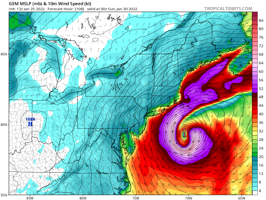
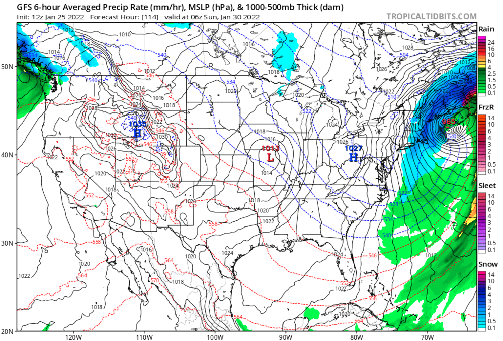
I doubt the CMC will verify, but look at the 10m winds on this sucker. Nearly looks like the wind profile of a bonafide Cat 2 hurricane

-
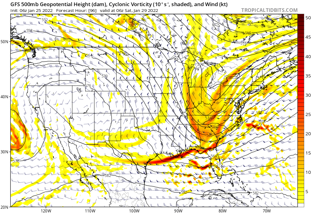
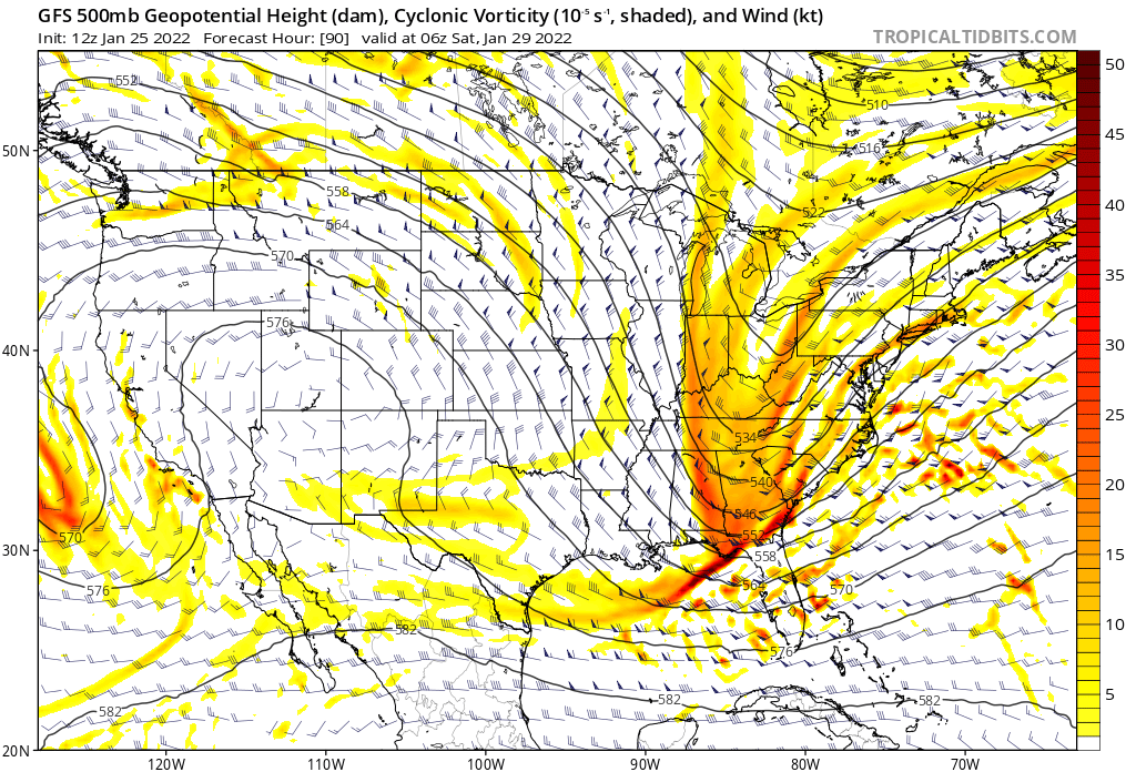
Come Sunday morning on the GFS and it's still snowing... if this was verbatim lots of eastern areas would see well over a day of accumulating snow... and look at that vort!
-
I've whipped up the entire immunology lab I work in with talk of a big storm on Friday/Saturday and now they are all independently hyped, if this busts then I'll be the cringey one
-
Is the NAM 84h generally considered to be more or less accurate than the 84h GFS?
-
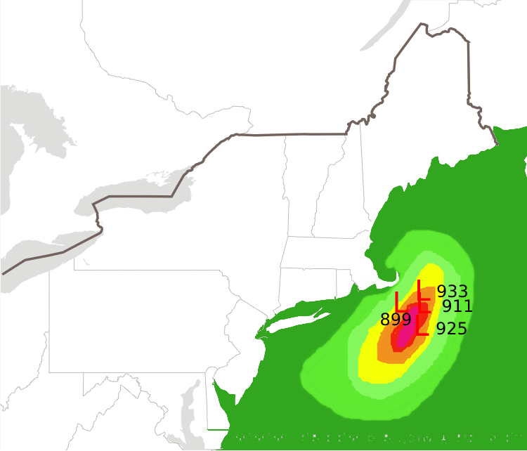
Some of these EPS members get in the 940's, when's the last time we've had a winter system that deep?
-
Looks like the cards are setting up for another model battle, should be exciting to resolve this week!
-
Compared to the EPS members this would be a middle of the pack-lower end solution, but I'd take the GFS verbatim. Hopefully it holds this look, if the southern stream is just a little more cooperative then boom
-
If the central pressure of this system ends up near the lower floor of modelled pressures (let's say ~960's mb), what could we expect for maximum winds? Given the current track Cape Cod would probably get the worst of it, but I could see a storm of this magnitude having a fairly large fetch of winds.
-
Just a general meteorological question; I understand that closed low pressure systems tend to form from shortwaves that elongate troughs to the point of separating them from a synoptic ridge/trough pattern and "closes" them off, but how come these low pressure systems tend to intensify so much more, and appear more symmetrical, over water?
-
We just need to stop the bleeding right now
-
My worst fear is that we'll see every subsequent model run back off slightly until by Friday we have a middling event
-
The Falcons just can't catch a break...